
A white label application is a branded digital product or service you can use as an in-house user solution or a product targeted for end-clients. There are many different benefits to adding a custom branded GIS application to your core business.
Some of the benefits of custom white label GIS apps are enormous opportunities to grow your brand reputation in the market, scale your offerings and focus more on the brand’s core values!
GIS Cloud can provide you with your personalized, custom tailored white label GIS application!
This is an out of the box solution, fully customizable and scaled to your business needs. GIS Cloud offers different white label applications within the platform.
What does this mean?
You can choose to white label any application within the GIS Cloud Platform mobile or web. This includes custom solutions that will focus solely on your business requirements without investing in hardware, software, configuration, coding, patching etc.
Here are some of the main things you will get:
- GIS Cloud Apps and features under your Brand
- Custom logo, style, layout, color and modules
- Custom domain or subdomain (e.g. www.mygisbrand.com)
- Localization and multi-language support
- Separate user space for your clients
- Fully managed hardware, software, maintenance, updates and upgrades (Cloud infrastructure)
- API support
- Premium Support
White label GIS applications can be applied to any industry and workflow such as:
- Electric Industries
- Water Utilities
- Road and Maintenance
- NGOs and Non-profit organisations
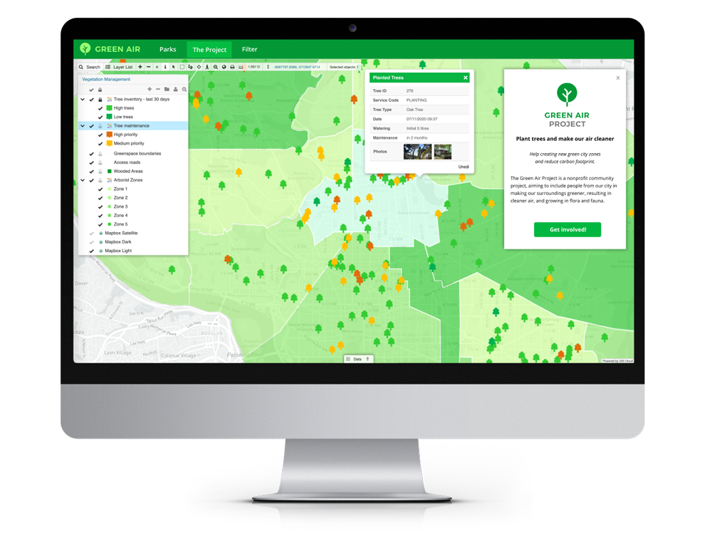
- Vegetation Management
- Agriculture
- Public Services
- and more…
Additionally, we can implement on-premises Enterprise Deployment within your private network behind a firewall. You can run the GIS Cloud platform and custom applications on your private servers!
It’s a quick and painless integration with your current desktop and client/server software that helps you follow your own control and security policies.
Build your GIS brand with the help of the GIS Cloud platform and developers!
Table of Contents:
- White Labeled GIS Map Portal – Customized And Branded
- Lewis County – Small Community Map Portal Solution
- CooperAcción Geoportal – Peruvian Geoportal For Sustainable Management
- CartoCrítica – White Label Environmental Conservation Map Portal
- Hydrological Map Portal – A Public Access To Water Resources
- Mobility For Everyone – Mapping City Handicap Parking
- Suhozid – Branded NGO Map Portal
- GIS Cloud Demo Map Portal
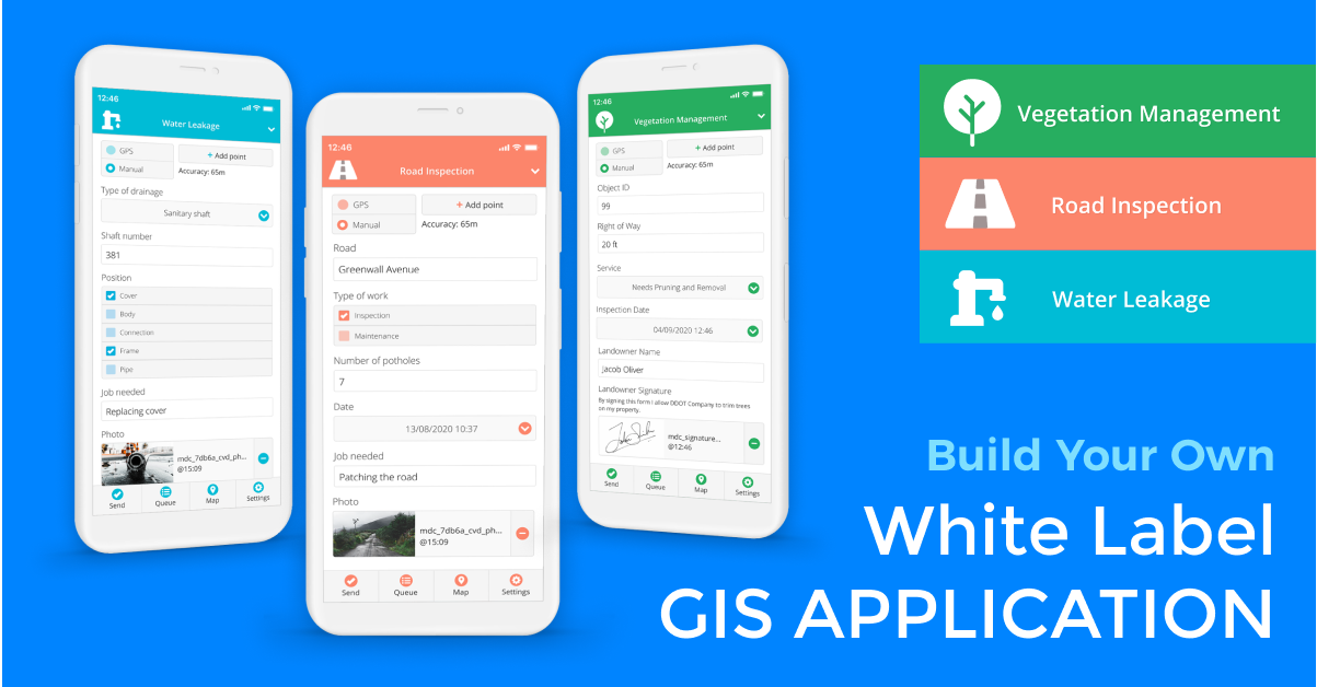
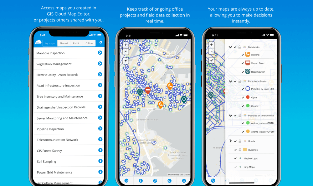
MDC – Flagship White Label Mobile Data Collection App
Having a website presence in business nowadays is just not enough. Mobile applications are a necessity for any online activities and also provide massive brand awareness.
More than 90% of mobile phone time is devoted to using apps!
With a white label Mobile Data Collection app, you get a complete solution, both Android and IOS, for field data collection and visualisation. It is a great value-offer for the in-app mobile store because it is building high-quality brand exposure.
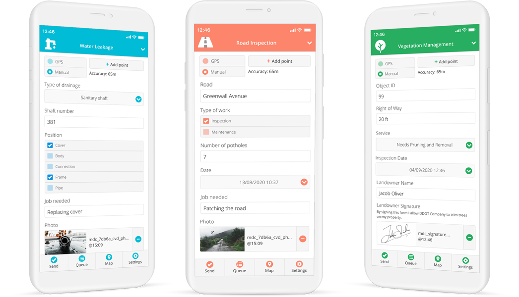
You get a branded mobile application with all available GIS Cloud MDC features for your users and clients to utilize in their everyday workflow. They will collect and inspect points, lines, and polygons under your brand the same as they would with our MDC.
All of the app functionalities are precisely the same. Users can build their custom survey forms, collect, visualise and monitor data in real-time, under your logo and brand appearance.
The following apps are real life examples, demonstrating how our partners and clients branded their applications on GIS Cloud technology.
SmartAqua – Mobile And Web App for Maintaining Water Supply Systems
Croatian water management and consulting company called Smart Aqua wanted us to build a white label mobile data collection solution for public water management and field data collection and visualisation. Numerous public companies still use paper form data, taking notes and partially transmitting them to digital content (excel, database, shapefile..) for reporting and statistical analysis.
Creating the Smart Aqua application enabled the company to provide to their clients a fully operating mobile data collection and visualisation system for all water management, water supply and sewerage infrastructure companies.
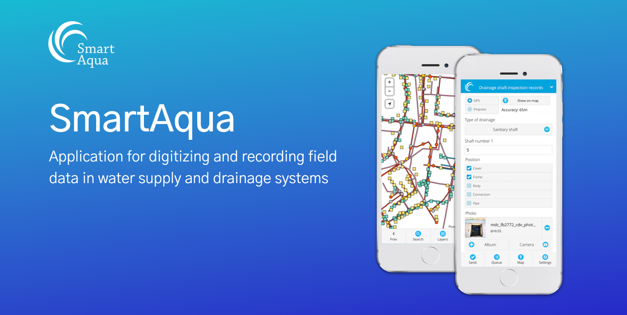
They gained notable brand recognition as one of the leading SaaS companies for innovative spatial data management solutions and public water supply system management.
With SmartAqua solution, their clients can instantly collect and record data in the field, digitize and visualise all of the information in real time, significantly improving all work processes, efficiency and transparency in public institutions. Clients can now use data for thorough and fast analysis. This helps improve collaboration between stakeholders and the public.
U-Collect – Data Collection Solution powered by Satellite-Based Infrastructure Technology
Asterra is a company that revolutionized the water industry with water leakage detection technologies that were previously used to detect water on planet Mars!
They use satellite-based infrastructure intelligence and provide data-driven solutions for utilities, government agencies, and infrastructure industries.
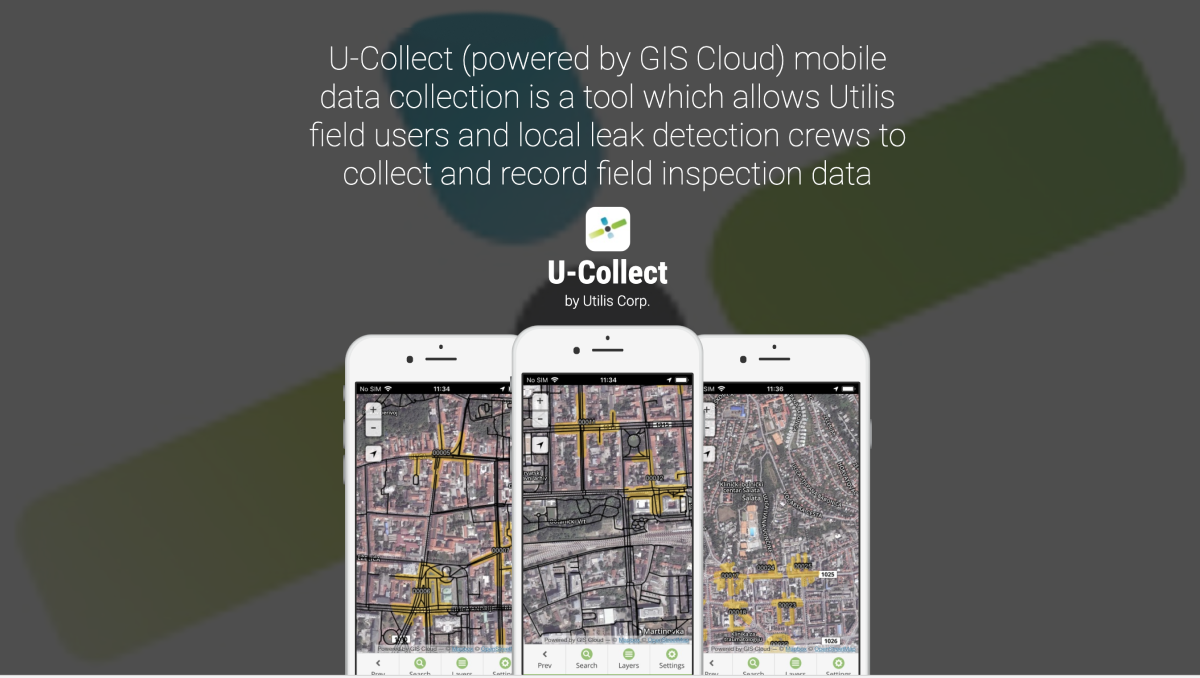
They wanted us to help them build a white label mobile application for client field data collection and management purposes. The main idea was to encourage Asterra users to stop using pen and paper in the field and access all of their data digitally from the palm of their hands.
We developed a mobile application called U-Collect that Asterra enabled for their users via Google Play and App Store. Users can now collect, report and visualize all water utility leaks within their branded custom solution.
The mobile application helped them provide the highest level of service and business standards, making them one of the solution leaders in satellite-based leak detection in the world!
White Label GIS Map Portal – Customized And Branded
Map Portal is GIS Cloud’s customizable online-based solution for visualizing, exporting and publishing geospatial data.
It gives you an overview of your mapping efforts and helps you display all of your data publicly. Map Portal is an affordable solution that publishes interactive maps to the next level without a single line of code!
If you need to share your maps and data adequately in real time with your stakeholders or the public, White Label Map Portal app is the way to go.
On a custom domain or subdomain (e.g. www.mygisbrand.com), you can enable public access to your maps with a personalized and branded map portal recognizable to your audience. Custom user interface and tools, with custom coloring, search, switch maps, and many more features available within the GIS Cloud App Builder.
Create reports, share or embed maps with required data and media included with just a couple of clicks.
You will find some interesting branded Map Portal examples from practice below.
Lewis County – Small Community Map Portal Solution
With their branded Map Portal Solution, Lewis County wanted to provide a simple solution for data-driven and real-time decision making. They needed to enable data to businesses and the public on a map to improve city management and collaboration across city departments.
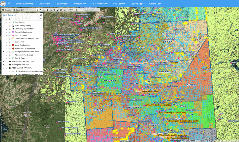
All of the spatial data is available to businesses and the public sector transparently on a map in real time. It helps engage companies and citizens to make faster and better decisions.
Find out more about Lewis County’s case study.
CooperAcción Geoportal – Peruvian Geoportal For Sustainable Management
CooperAcción is a Peruvian non-profit association that promotes the knowledge and exercise of social, environmental, political, cultural and economic rights. They try to find solutions for sustainable management of the territory with gender and intercultural approaches.
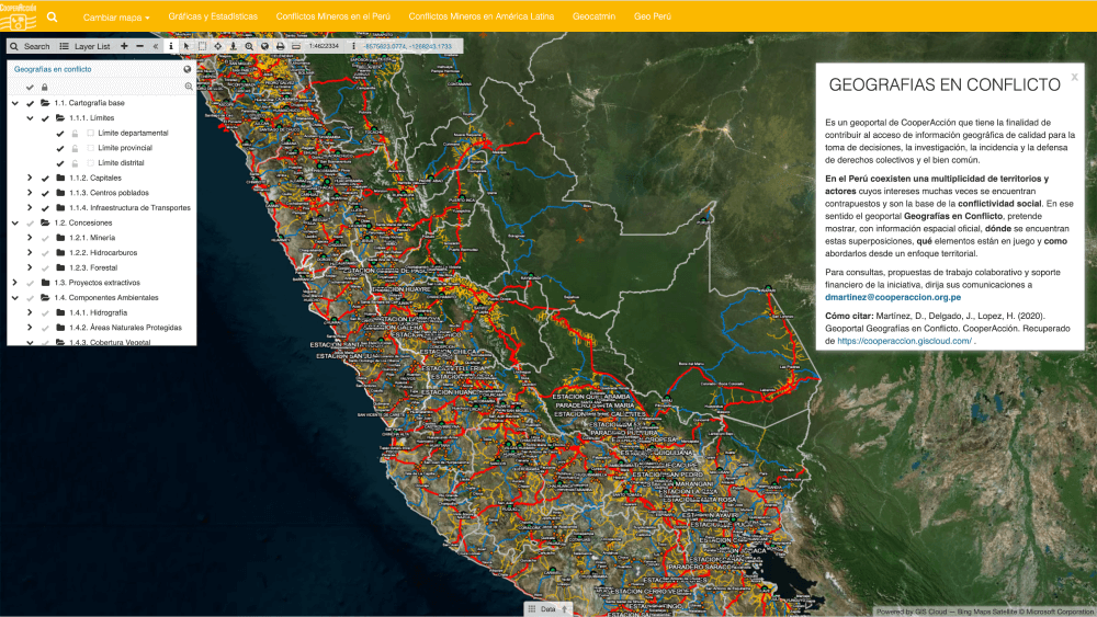
Their white label Map Portal aims to contribute to quality geographic information for decision-making, research, advocacy and defence of collective rights and the common good. In Peru, a diversity of territories coexist whose interests are often opposed and are the basis of social conflict. This Map Portal contains official spatial information that helps them see what spatial elements are at stake and how to approach them.
CartoCrítica – White Label Environmental Conservation Map Portal
CartoCrítica is a Mexican non-profit environmental organisation that promotes transparency and public access to georeferenced socio-environmental information.
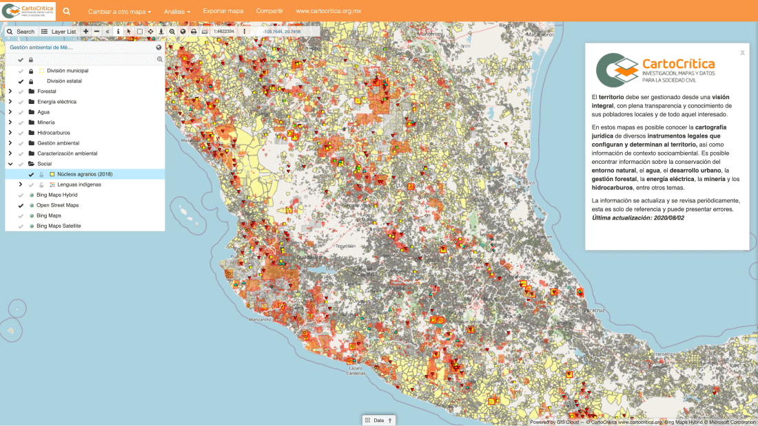
With their extensive Map Portal, they wanted to create a transparent and open network of data on a map, in open formats, to understand the Mexican territory’s comprehensive management, human rights, and conservation of biological and cultural diversity.
In simpler words, “extraction of water, oil, gas, minerals, on whose land?”
Hydrological Map Portal – A Public Access To Water Resources
Monitoring and modelling the comprehensive hydrological data is essential in creating a sustainable system for managing the public water supply.
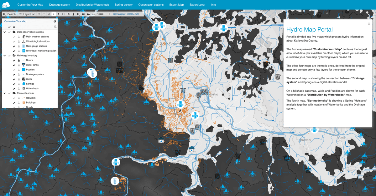
Having to find and track down needed information manually is inefficient and unreliable. This project brought the hydrology data to the broader audience, civil engineers, geo-technicians, scientists and hydrogeologists.
Since the Hydro Map Portal is publicly available all third parties can freely download the layers and data.
Mobility For Everyone – Mapping City Handicap Parking
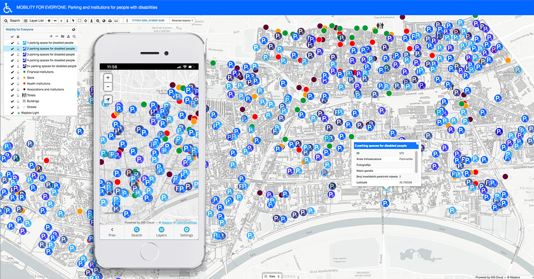
The soul goal of this project was to help people with disabilities in their everyday activities within the city limits. Team of students focused on mapping the city infrastructure that helps people with disabilities and presenting it on a publicly accessible branded Map Portal.
The significant advantage of the Map Portal is that the data can be filtered, which simplifies the work with a map.
Suhozid – Branded NGO Map Portal
Mapping and data visualisation for any NGO or nonprofit organisation needs to be cost-efficient and straightforward! Additional development maintenance, upgrades or administration complicate things and require volunteers skills and time.
Dragodid’s project – “Suhozid” on restoring and preserving dry stone heritage in Croatia almost came to an end because their previous mapping solution was too complicated to develop and maintain.
Helping them continue and overcome their challenges and building a unique white label custom Map Portal was a privilege. Building dry stone walls is of great historical importance in Croatia. Within their Map Portal, you will find all locations of historic dry stone sights with media attachments and information.
GIS Cloud Demo Map Portal
We have fantastic team buildings. During our last GIS Cloud Mapathon Challenge, sponsored by beers and pizzas, we created a Demo Map Portal with switchable maps, displaying different industries with relevant data. The goal was to show potential users the capabilities of our Map Portal application like custom interface, branded colors, the organisation’s logo, and many other possibilities that our App Builder provides.
GIS Cloud Map Portal Solution is also highly susceptible to spatial visualization with animated graphs!
With GIS Cloud API and D3.js integration, you can enrich your Map Portal with interactive graphs and help your users understand the data better.
GIS Cloud’s Complete Branded Crowdsourcing Solution
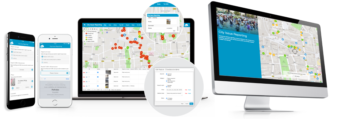
Crowdsourcing solutions are web or mobile applications that collect different types of data from a large number of users.
Do you want to engage in Smart cities, innovation, problem-solving and effective online communities, Crowdsourcing is the best practice for common goals. If your community has important things to say, a Crowdsourcing solution will unquestionably drive the conversation in the right direction.
Social media and apps brought organizations even closer to the stakeholders and communities by creating a much easier platform and value for collaboration and cooperation.
With Branded GIS Cloud Crowdsourcing Solution for:
- Organizations
- Cities
- Public
- NGO’s
- Government
- Healthcare
- Environmental protection
- Unemployment issues
- Resource management
- Crime rates
- Urban sprawls
- and much more…
clients can make a collaborative crowd-centric approach that will make a profound community impact!
GIS Cloud Crowdsourcing solution provides configurable applications, customized and branded for each client or user individually.
Once the Crowdsourcing Mobile App is built and branded, citizens and organization members can download it directly from App Store or Google Play and fill the custom forms. Simultaneously, public Crowdsourcing Web App is instantly accessible, and it allows citizens to report issues online from their desktop computers anonymously.
Crowdsourcing is a strategic model and a perfect solution for engaging organizations, stakeholders and citizens to report and evaluate issues that will make them more involved in the decision making process. Organisations can track progress and have an overview of the data with the ability to approve submissions that will be publicly visible. This just might be the perfect solution to your challenges.
How does this work in reality?
Let’s find out.
STOP Corona! – Crowdsourcing White Label Healthcare App
STOP Corona! Crowdsourcing project was a joint effort of a great team of experts, organisations and volunteers worldwide who felt the need to help in the Covid-19 crisis.
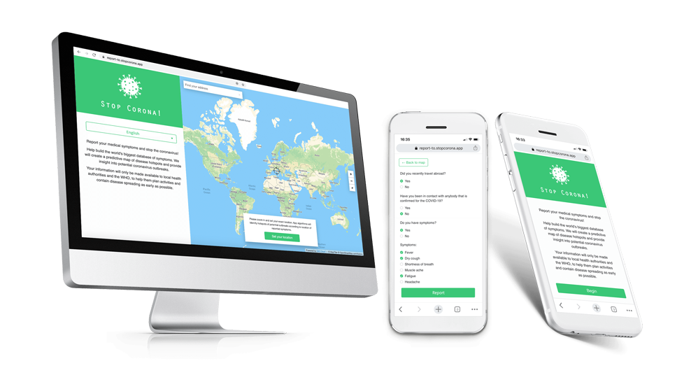
They united their knowledge and resources to help communities and the world. Using real-time location intelligence and machine learning, the STOP Corona! App can predict patterns and locate hotspots of potential new virus outbreaks.
The goal was to detect potential hotspots of the virus spreading and enable public and health authorities to gain insight into the symptoms in real time on the map! Most crucial element of this project was to enable the heatmaps health officials for free, to help them gain insight and optimize their efforts in containing the virus spread.
The information was not available to the public due to privacy and security concerns and was collected securely through an online form with SSL encryption.
Mapping World Kindness – Non-profit White Label Crowdsourcing Solution
Sending data on a map in real time across the world was never more important than in this project!
LifeVest Inside, a non-profit organization that inspires, empowers and educates people of all backgrounds to lead a life of kindness, used GIS Cloud’s white label crowdsourcing solution to increase their projects’ visibility and impact. They made kindness go viral and utilized crowdsourcing solution for small acts of kindness spreading throughout the world on an interactive map.
Restoring The Historical City Center Of Mantova – White Label Public Crowdsourcing Solution
Having a valuable cultural heritage recognized by UNESCO, but not being properly maintained and publicly abandoned is a big issue for the Municipality of Mantova in Italy.
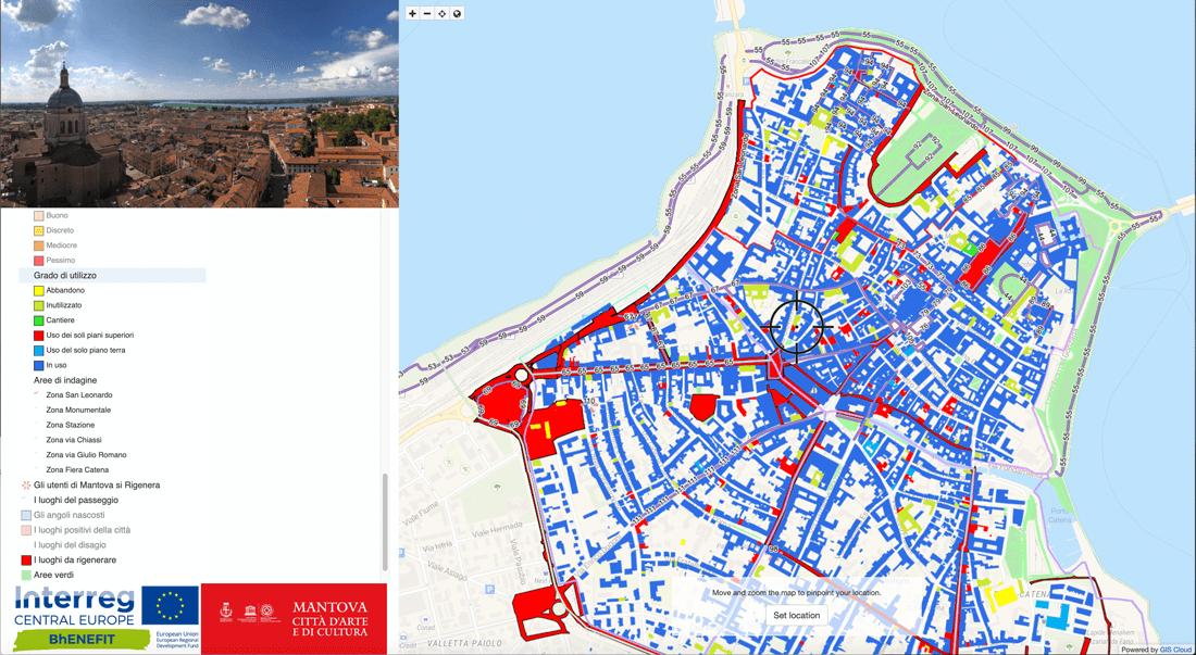
They needed to find a way to engage citizens and various organizations to work together. The goal was to identify and monitor the areas in need of restoration. White label crowdsourcing application was, in this case, a smart city solution for Mantova.
Citizens used the app to select locations of damaged historic buildings and sites, fill out a questionnaire (form) and upload photos to help the officials perceive the issue and respond accordingly. Mantova citizens utilized the application and GIS platform to help create an urban regeneration strategy from a different perspective, helping personnel and officials analyze and consider various issues.
Map Viewer – White Label App For Real-Time Data Viewing and Decision Making
Map Viewer mobile and web application is a quick and easy way to browse private maps, shared with you in real time! It is optimized and accessible on any device, both for Android and iOS. This is ideal for stakeholders and management to quickly view the project’s state and make informed and fast decisions.
Map Viewer is a collaborative solution, fully customizable and scalable for your branding purposes. You can white label the app and make it recognizable for your users and clients to view the data and make decisions in real time.
It is essential to mention that Map Viewer enables viewing large maps rich with features quickly, with unmatched rendering speed. A whole new experience. Intuitive, straightforward and synced real-time solution suited even for non-GIS professionals!
U-View – White Label GIS Map Viewer
We mentioned earlier that Asterra company revolutionized the water industry and is one of the leaders in satellite-based leak detection of the world! Asterra found a crucial partner in GIS Cloud and successfully integrated their technology with our platform into one complete solution. U-View is part of their joint solution along with U-Collect and serves as a fully operational real-time overview of field data for their users and clients.
It is a perfect branded collaborative solution for managers and stakeholders to retrieve all of the needed information and make critical decisions in real time.
As presented so far, you can see that GIS Cloud is a versatile and modern platform for real-time collaborative data collection and visualization that helps you make faster and stronger business decisions.
One of the fastest and robust Map Engines in the world enables you to render maps at a fantastic speed, creating a powerful platform for rapid White Label App Development!
Build your own custom, branded GIS applications on top of our robust platform with a rich and powerful API that will help you develop entirely custom and suitable solutions for your business!
You get your own secured and private cloud servers at Amazon Web Services, renowned for their reliability and security. If you prefer private cloud solutions, we also offer customized on-premises installations.
We encourage you to Sign Up to explore our platform and try all our premium features completely free for 14 days!
If you are interested in any of our products and services, please contact GIS Cloud Consultants!