Many governmental departments just recently started to discover how to benefit fully from geospatial technologies.
This particularly affects the planning, public works, and services departments that need to have adequate tools for data visualization.
Having all of that on a custom map in real time might be a game-changer in terms of creating an effective future workflow. This regards sharing the data on current projects such as infrastructure maintenance and development between the departments, sub-departments, ministries, and other smaller and larger organizational units.
In conducting the project on a larger scale, it is also important to have good infrastructure for making the information publicly available, completing a data flow circle with the best possible outcome.
An example coming from the Secretariat of Public Works, a department of the Argentine Ministry of Federal Planning, Public Investment and Services shows how the needs in the public sector can easily be met with a simple government mapping solution.
Delivering Online Access For 45.000 Federal Public Works
The imperative coming from the department was to have a reliable, fast, and cost-efficient data sharing and publishing solution. What the Secretariat of Public Works had in mind was to unlock access to information to their citizens on more than 45 000 federal public works. The projects which were to be shown on the map were the result of GIS local government programs conducted in the last 12 years, as a collaboration from different departments throughout Argentina.
All that information, concerning various works in the healthcare, education, transportation, residential and other parts of infrastructure should be easily accessed and managed by both administrative staff and the citizens of Argentina.
In the process of finding the perfect solution for sharing and publishing the data, the biggest challenge was to find a way to escape from the ‘inertia’ of having the GIS data limited to desktop solutions.
The centralization of the data storage on individual computers had its faults. It was difficult to share the vast amount of collected data in various formats and on different devices with other people, and there were even more challenges in the distribution of data to the broader public. A unique methodology and a platform for data sharing and management was the essential requirement for this project.
Using The Custom Online GIS App Portal To Process The Data
The answer was simple. What the Department of Public Works needed was a cloud solution. They needed a platform for which the only requirement was to have a browser and Internet access. The department was recommended to use the GIS Cloud applications, which met all the requirements for the Argentine government data publishing project.
In the first phase of the project, the expected platform needed to have the possibility to and share the data in collaboration with different users. Also, information about the particular education, health, or transportation facility had to be stored online. GIS Cloud Map Editor helped them execute the first phase of the project smoothly. Data was uploaded directly in the cloud and stored safely. Map Editor is rich in GIS symbology and it has built-in collaboration capabilities which allows real-time editing and sharing.
This made the second phase of the project accomplishment even easier. With Map Viewer, information on the map was clearly shared with particular users coming from different departments. Map Viewer is optimized for non-professionals and enables you to access shared or public maps on any device in real time.
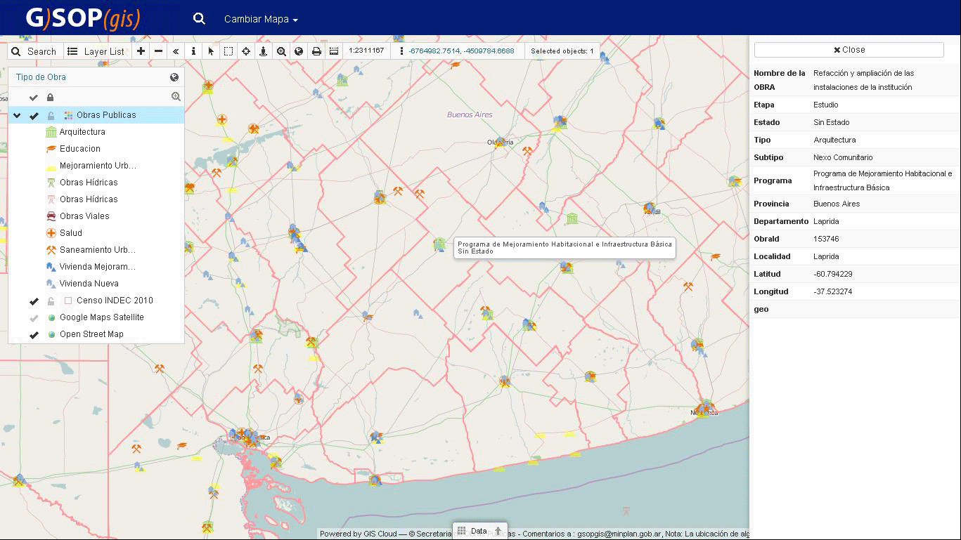
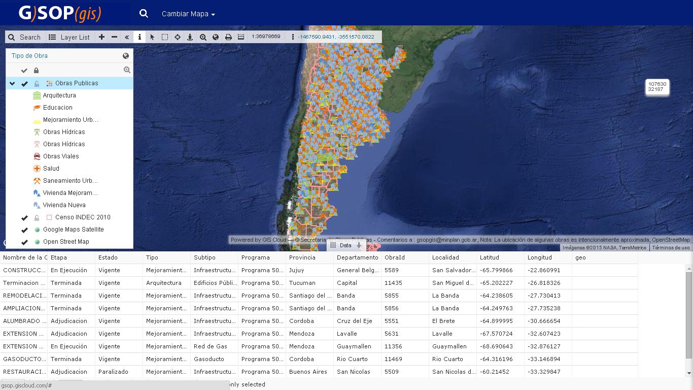
The Online Public Map Portal
Finally, when data was prepared and ready for public access, the GIS Cloud Map Portal was a perfect publishing solution. It is a simple and easy custom GIS application that gives you an overview of your mapping effort. It is fully branded for the department’s needs.
You can see the results in this video presentation.
The Final Result
Marcelo Alejandro Portela, a consulting specialist, sums up the main benefits of the successful integration of the GIS Cloud solution in three points:
- the excellent performance gained by html5
- easy navigation through various map layers using the “search” feature
- the simplicity of use.
The main advantages of using the GIS in government, attested by Mr. Alejandro Portela are:
the fact that the user interface is easy to use even for the non-GIS experts (commonly represented in the administrative staff), at the same time, offering the fast and high-quality data visualization solution, easily accessible anytime, from any device.
If you want to know more about the GIS Cloud solution for Government, Contact our Solution Consultants.