
Each year the number of cars in the city grows, causing traffic jams and lengthening the time spent looking for a parking place. That leads to dissatisfaction and stress among drivers.
Marija Milanović, geodesy student at the University of Zagreb, created an interactive Map Portal of parking zones and no fees parking spaces in the city of Zagreb.
The idea was to make a map that shows parking lots and garages, both private and public. The user would have all the essential information in one place. It would make it easier for them to find a parking space, saving time and money.
Measures like high prices, limited parking spaces, and restricted parking hours aim to reduce the use of on-street parking (permitted parking spots on the street) and replace it with off-street parking (spaces for cars located on private property rather than on a public street).
With that, more space opens up for pedestrians and cyclists, and it has a positive effect on the entire ecosystem, including less air pollution, less noise and vibration.
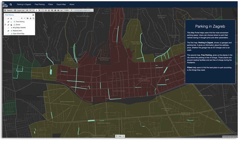
With all available garages and parking spaces in mind, drivers can choose parking that suits their interests. Additionally, due to the Covid 19 crisis, there are no parking expenses around health facilities. These areas are also presented in the map portal.
Preparing and Gathering the Data
To model this kind of map, one that integrates information about parking zones, parking lots, and garages, relevant information from different sources needed gathering and vectorization.
On the Zagreb Parking website, there is a list of streets grouped by the parking zones.
The list was used to manually mark parking zones in Map Editor and later distinguish them with different colors. Zagreb parking also provides information about areas near health facilities with free parking during the Covid 19 pandemic.
For mapping garages and parking lots along with relevant information like price, address, the existence of a car wash, and a charging station for electric cars, the ideal solution was to use Mobile Data Collection.
The application is user friendly and very intuitive to use. It provides fast collection and inspection of gathered data.
When gathering the data about garages and parking lots, the first step was creating a collecting project with an appropriate survey (form) in GIS Cloud web application. The form can be easily modified and edited at any moment in the application.
The next step was collecting the data in the field using the created mobile survey.
While some of the mapped garages are stand-alone, others are accompanying facilities like plazas and parking lots. As for the parking lots, Marija mapped only those with pricing different from the one determined by the parking zone, thus excluding parking lots that are just street extensions.
After mapping the zones and gathering the data about garages and parking lots, Map Editor contained three layers:
- one polygon layer
- two-point layers
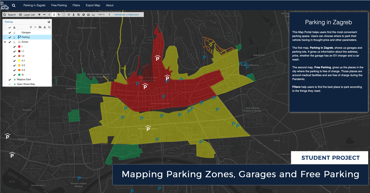
Parking zones in the polygon layer are marked in different colors, a color for each zone. Garages and parking lots, which are in the point layer, are each marked with appropriate signs.
The sign for garages is the white letter P with a symbol that indicates the roof. For parking lots, a simple blue letter P was used.
By clicking on any feature on the map, a window pops up with all the relevant information. All of the needed changes are quickly done in Layer properties in the Map Editor.
Creating A Custom Map Portal For The Public
All of the collected data was published in Map Portal, a custom GIS app branded with logo and colors.
Using the GIS Cloud App Builder, the layout of the Map Portal was edited and organized. Users can switch between two maps, Parking in Zagreb, with garages and parking lots, and Free Parking, with areas free from parking charges.
Users can apply various filters, depending on their needs. Filters make it possible to explore the garages to see whether they have chargers for electric cars or a car wash.
Users can also filter parking lots and garages depending on the hourly price of parking during the working week.
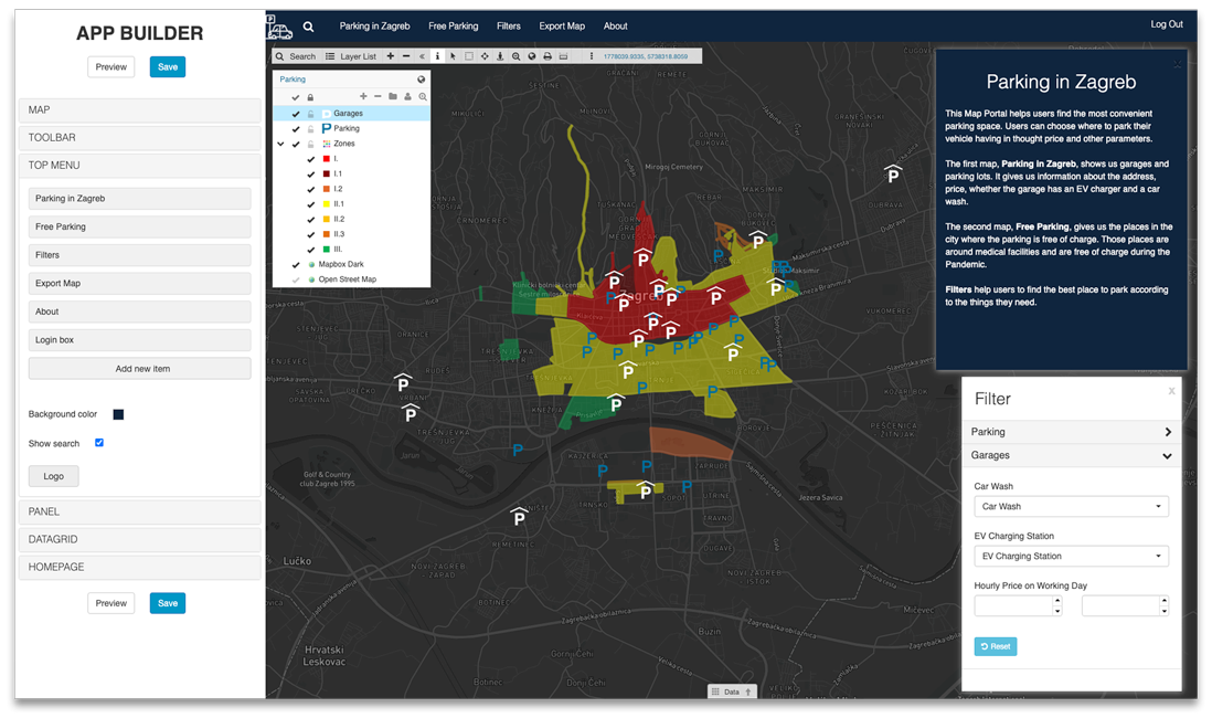
The App Builder enables us to create a Map Portal with different options which then help us present the data and content on the map more neatly. You are able to customize the Map Portal by:
- setting a default map
- managing toolbar buttons
- choosing the custom logo
- changing the ribbon colour
- managing different panels
- and much more
By adding filters, users can search for a place to park their car depending on their preferences, whether they need a car wash, electric car charger, or can choose by the preferred range of price!
Browse the Parking Zagreb map portal → here.
The Map Portal displays two distinguished maps you can switch between easily in the ribbon section. One map displays garages and parking lots in the city of Zagreb, and the other map shows us areas free from parking charges due to the situation with Covid 19.
If you want to learn how to build your own Map Portal, take a look at this webinar.
Results And Conclusion
The whole project lasted for four months. The most challenging part was creating the polygon layer.
There is no updated graphic display of parking zones in the City of Zagreb on a map, only a list of streets by zones. This list was combed through until getting contours of zones, which were eventually used for drawing polygons in the layer with zones.
Thanks to Mobile Data Collection, data on garages and parking lots were easy to collect in the field, although some are not well-known, and detailed research was required to collect all the data.
Working in App Builder to clearly visualize the data in the Map Portal was intuitive and allowed playing with design.
We believe that this Map Portal will benefit all users who wish to plan the most affordable parking visit in Zagreb.
If you want to build your own Map Portal app and learn more about GIS Cloud apps and services, Sign Up for the free 14-day trial.