Teramaps is a GIS Cloud partner that offers technical solutions for their clients’ geography needs. They integrate QGIS’s desktop applications with GIS Cloud’s online solutions to deliver valuable tools throughout Chile and across South America.
Their clients range from a variety of industries, including municipalities, power and gas companies, the Chilean military, universities, shipping companies, and many others from across the continent.
We are going to explore the services they offer and how they helped modernize a nationwide police force.
GIS Cloud Partner
As a GIS Cloud Partner, Teramaps has been a long-time user of the platform. They have used GIS Cloud since 2015 and continue to do so. As a GIS Cloud Partner, they are experts in geospatial solutions and GIS Cloud.
GIS Cloud Training
As experts on the GIS Cloud platform, they are a highly qualified organization. They have maximized the capabilities of using open-source GIS solutions like QGIS.
Teramaps offers training on integrating QGIS with GIS Cloud. The training will include data processing, analysis, and presentation.
Geocoding
Geocoding takes a list or table of addresses and locates them on a map. The process is automated with a geocoding tool. Teramaps offers this as one of their services.
Teramaps has invested in accurate address positioning throughout Chile. They have worked on cadaster data throughout the country as part of projects for their private and public sector clients.
Map Viewer
The Map Viewer is an application developed for presenting data to non-GIS users. The deliverable is an easy-to-use map and data viewer.
There are tools for identifying layers and features within the dataset.
The Map Viewer can be customized with your organization’s logo and branding. As the administrator, you can set the access permissions on the maps and data within your viewer.
Mobile Data Collection
Collecting field data is an important part of a GIS. Data is the backbone of powerful analysis and leads to better decision-making. The Mobile Data Collection (MDC) application is a powerful mobile application available on IOS and Android.
With the MDC, Teramaps’ clients collect data in custom forms. The forms can be set up for point, line, and polygon data. The data captured can include photos of the asset.
As soon as the data is collected and synced in the field, it is made available to all the users on the GIS Cloud platform. Users can collect items like water meters, pipelines, and property boundaries.
If accuracy is important, the MDC application can connect via Bluetooth to an external GNSS receiver and capture high-accuracy data.
Map Portal
The GIS Cloud map portal is a hosted application that presents your maps, data, and assets to the public. The interactive maps allow users to search and query your data.
This is a great example of how to develop a hydrological map portal
Teramaps creates such map portals for their clients. They are able to customize them with their clients’ logos. These have served as excellent tools for clients presenting to the public.
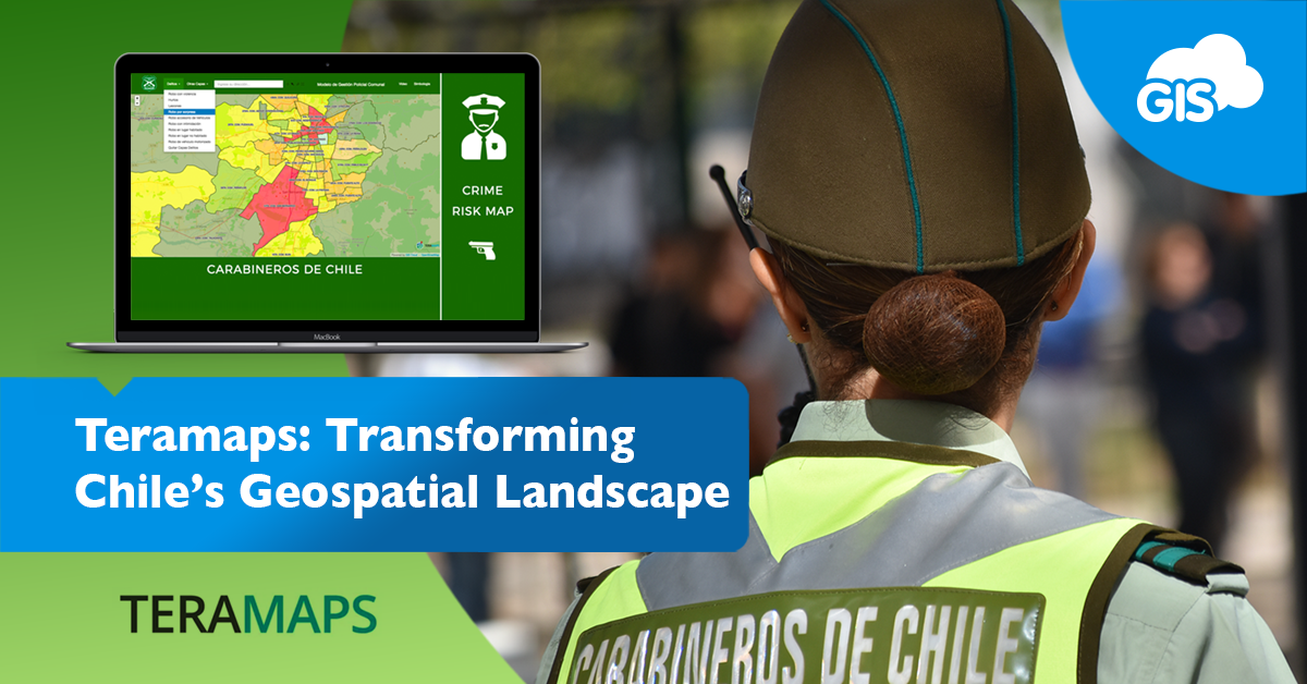
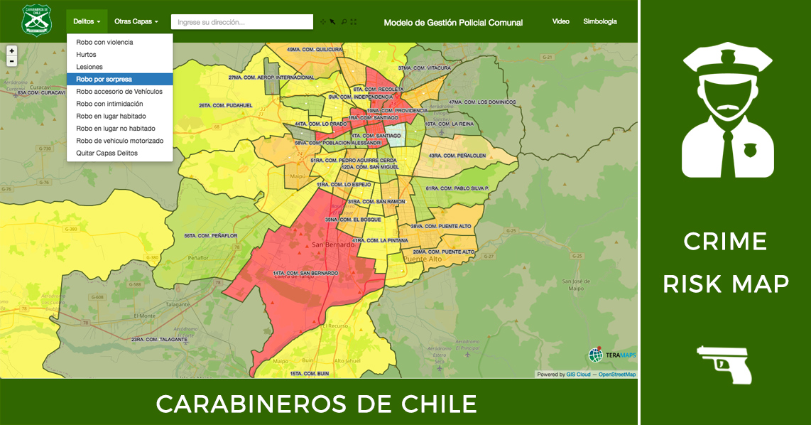
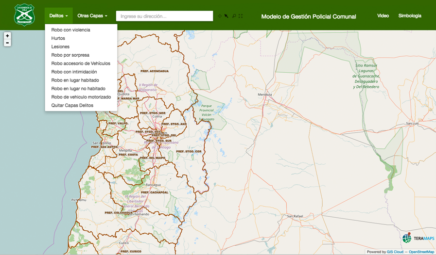
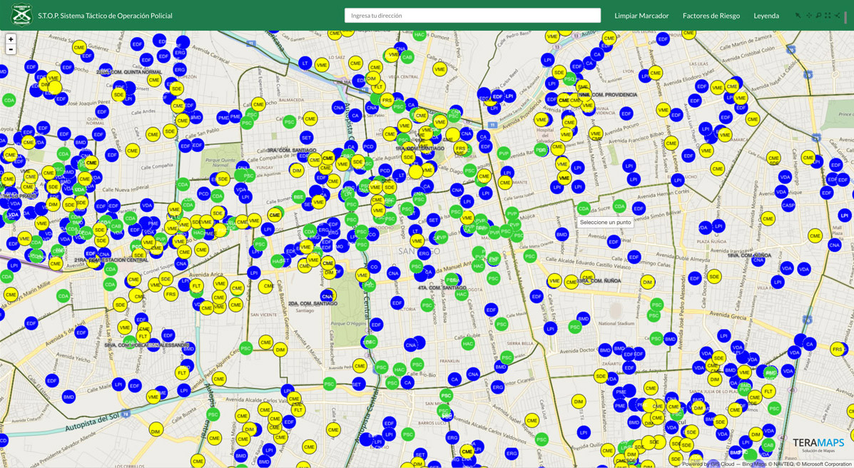
Modernizing a Nation’s Crime Data
The Carabineros of Chile are the national law enforcement military group of Chile. They maintain order and security throughout the country for citizens.
During times of peace, they serve as a police force to communities. When war situations arise, they mobilize as a branch of the Chilean military.
Due to their nationwide jurisdiction, they needed to rely on geospatial experts like Teramaps for their data and analysis solutions.
Teramaps developed a GIS Cloud Map Viewer for the agency. The Map Viewer shows crime data as and areas of concern for fires, road conditions, and protests.
The map data provides the unit and detachment for the selected area.
A feature that receives high praise from the Carabineros is the query and reporting function. The reports provide data by week, zone, unit, detachment, and quadrant. Built into this report are fields that track the changes in the data. The fields identify increases and decreases in crimes weekly and month-by-monthly.
Teramaps has created a powerful tool that organizes the agency’s data in a centralized location. The different Zones report their data, and it is immediately available to everyone in the organization.
Their crime fighting efforts can also be analyzed, and their impacts can be measured and backed by accurate data.
The Teramaps Crime Risk Map was featured on our blog a few years ago and provided an in-depth look at the process and methods used to provide the final product.
Conclusion
Their resume demonstrates their expertise in GIS and cloud solutions. Teramaps has served many clients around Chile and throughout South America.
Their services have helped modernize agencies throughout the continent and empowered the public to be in the know. Their training has supported QGIS open-source software in providing an affordable option for GIS tools.
If you need a geospatial solution, sign up for GIS Cloud’s free 14 day trial and experience all the premium features.