Being a cloud based GIS solution doesn’t stop with a mobile application. GIS Cloud has other tools that can be used to improve your team’s fire hydrant inspection routine.
We will show you how GIS Cloud’s online solutions can solve your fire hydrant inspection frustrations. Many of these solutions will solve these headaches with one action.
>You can address these challenges right away by simply signing up for our free 14 day trial.
What are the Challenges of Fire Hydrant Inspections?
Data collection in the field can be challenging, but it doesn’t need to be. In our 10 years as an online GIS solutions company, we have addressed many of these concerns.
Our tools have been designed and refined to alleviate these challenges and make GIS a tool for everyone to use.
These are the common concerns and roadblocks we frequently hear. We are going to demonstrate how these can be overcome with our solutions.
- Digitized GIS Data: Don’t our paper maps need to be digitized to get started
- Affordability: GIS is expensive
- Data storage: We don’t have the storage space on our network
- Thorough Inspection Forms: Our paper forms can’t be replicated to a mobile application
- Planning for the future: Our asset management system isn’t forward looking
- Public Outreach: We can’t afford to give the public access
Digitizing your Water Assets for GIS
By digitizing your assets into a GIS environment, you are unlocking the many tools of GIS Cloud. The process of digitizing your assets and utility network from as-built plans and old paper maps is time consuming.
The steps required to digitize from these old maps are ridiculous. You will need to:
- Locate the physical record
- Scan the map
- Organize it on your network
- Name it properly
- Upload it into a GIS solution
- Georeference is as best as possible
- And finally, map the assets
We have a different option for you.
Using one of our many industry focused templates, you can begin mapping using the Mobile Data Collection (MDC) app immediately, or you can collect the field data through the inspection process.
Here is an example of an inspected fire hydrant and now collected data point:
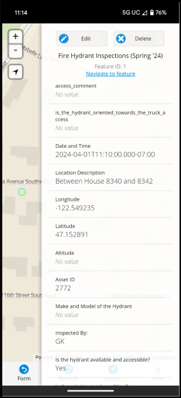
Just create the inspection form you would typically use in the field and perform the inspection using the MDC app. The application will collect all the information you need for the inspection as well as the coordinates of the fire hydrant.
If you come across a water valve, you can change maps on the app and capture the water valve in seconds.
Back in the office, you can confirm details like water line sizes and inverted elevations.
Let’s bring intelligence to your hard working assets!
Is GIS expensive for collecting field data?
We believe GIS should be an affordable option for everyone. Try all of our GIS tools during our free 14 day trial.
If you are still hesitant, we understand. Many companies bury their pricing structures in hundred page documents.
You can find our’s here: GIS Cloud Pricing
We allow you to choose the tools you need. Only pay for the options your team uses.
Where can I store my GIS data?
GIS is built on data. That data comes in many different types and sizes. You might have a layer of points taking up a few megabytes all the way to 1000s of acres of raster imagery.
If you try storing that locally on your PC, you create a silo. The other option is storing your data on the network. Let’s see how long it takes before you need to ask IT for some storage.
GIS Cloud has affordable options for all your GIS storage needs.
With GIS Cloud, your data will be stored in the cloud. You and your team can access it from anywhere, anytime. Our global partners and clients are proof of that, from Adelaide, Australia to Switzerland and beyond to Uganda.
Create Versatile Forms in the MDC Portal
One challenge of a fire hydrant inspection is having a comprehensive form. Replicating a spreadsheet inspection form can be challenging.
There is a lot of freedom in how you use the space and specific boxes may need to be filled under different occasions.
Our flexible forms can do all that.
In the MDC Portal, you can create a smart form. This form can mimic your printed inspection form and be available on the go through the MDC application.
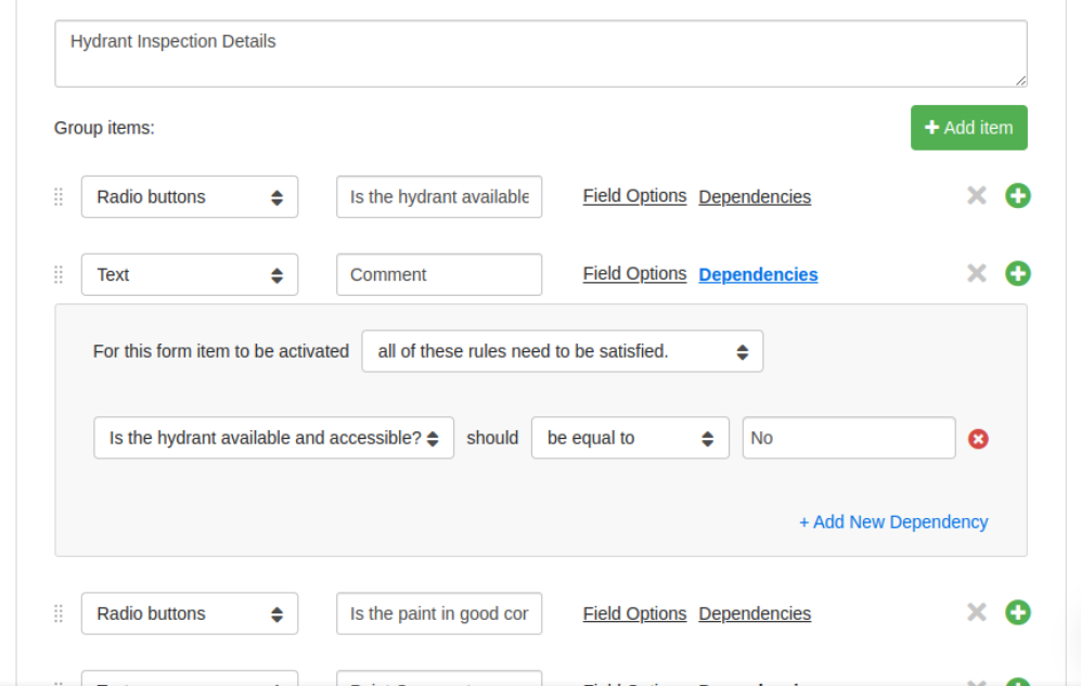
The example above shows how a comment field can become available if the question, “Is the hydrant available and accessible?” is answered “No”. This allows your crew to add comments tied to the specific observation from the field.
Here is the list of form items you can collect in a Mobile Data Collection app:
- Text
- Number
- Date and Time
- Select List
- Check boxes
- Radio buttons
- Signature
- Hidden Field
- Photos, Videos and Audio Recordings
- QR and Barcode
- Username
- Device ID
- Device model
- Device version
- Device platform
- Latitude and Longitude
- Altitude
- Speed
- GPS Heading
- Compass Heading
- Accuracy
- Altitude Accuracy
- Time
Some of these fields are collected in the background and won’t clog up your inspection form.
Other options include rules that you can set for your fields. You can make fields required or dependent on other data entries, like in the example above, or even repeat the previous entry.
Default values and unique values can be set with a click of a single check box.
In minutes, you can recreate your field inspection form and save your inspectors a lot of hassle during the data collection process.
If you have any questions about these items, our Knowledge Library explains what each one is capable of and covers everything there is to know about the MDC form capabilities.
Being Prepared for the Future and Emergencies
Your update to date GIS will have all the answers to your questions. It can be the sole source for anything you or the decision makers may want to know.
An online GIS record keeping solution will make your maintenance and inspection dates readily available. The last inspection dates can be shared internally in a dashboard or Map Portal.
By capturing all the information available on an asset, you can plan for the future. Asset replacements can be forecasted years in advance. Budgets can be adjusted to meet the upcoming costs required.
In the case of emergencies, staff will know how the system is connected and have a clear understanding of what residents or businesses will be impacted during shut offs.
An analysis can even tell you which specific addresses will be impacted during a water shutoff and the number of customers who need to be informed.
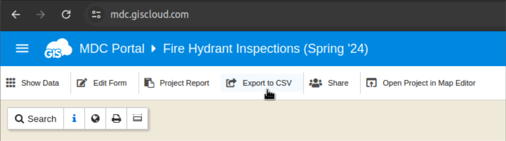
If you need to analyze data further, the GIS data can be exported as a CSV from GIS Cloud.
Data is powerful, and data in an online GIS solution shares that ability throughout your organization, enabling everyone to make smart decisions in critical times.
Educate the Public about Your Inspection Efforts
Your customized Map Portal can be a great information tool for the public. This Map Portal can be customized with your logo and organizational style temples.
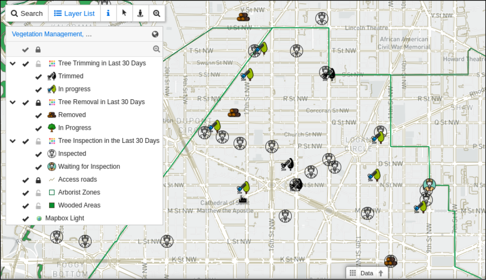
This demo Map Portal shows a Tree Inspections and Work Order map portal. You can see what trees have been inspected and the Arborist Zones, along with their contact information.
Being an open book gives the public peace of mind to the efforts addressing their concerns.
During a Fire Inspection, should a shut off need to take place that impacts nearby residents, they can be involved in multiple ways. You can also analyze your new GIS data to see which residents will be impacted.
Conclusion
Asset inspections like on fire hydrants may need to be performed semi-annually. Let our GIS Cloud solutions speed up the process, save you time and time, and ease the workload on your field crews.
Our affordable pricing and flexible inspection forms can be customized to fit your organization.
If you want to create your asset inspection form or build your map portal, sign up for our free 14 day trial. All of our tools will be readily available to you.
Our Solution Consultants can help you and your organization as you continue your GIS journey.