The crew from Global Code Technology successfully finished the field data collection of infrastructure, land use and property in less than two months. It was a project for the Zarcero Canton that needed to get their housing census database in order. The housing census enabled the canton to plan infrastructure projects more efficiently, like bringing electric utilities to each resident or fixing the damaged public property.
Learn about the field workflow and the GIS tools they used to finish the data collection before the deadline.
Table of contents:
• Census Data Mapping – field workflow
• Deploy licenses to the field crew
• Create project in Mobile Data Collection Portal (MDCP)
• Overseeing the progress of the survey
• Creating cartographic products with QGIS and Map Editor
• Global Code Technology explains why they used the GIS Cloud platform
About the Zarcero Canton
The Zarcero Canton is situated in a lush region in continental Costa Rica some 44 km North-West of San José, the country’s capital. The canton rests on an altitude of 1740 meters with hills rising from and streams cutting through the green landscape. The settlements stretch across the hills as you can see on the picture.
 Flickr.com
The landscapes aren’t the only thing in Zarcero worth mentioning. There is also a dinosaurs bush in the center of the city. The best kind of bush if you ask us.
 Flickr.com
Seeing all of this, It’s no wonder the surveying team from Global Code Technology (GIS Cloud partner for Costa Rica and Panama) had a great time while mapping the Zarcero Canton. Now let’s take a look at their field workflow and the GIS Cloud apps they used.
Census Data Mapping – field workflow
The Zarcero municipality wanted to know what kind of access do citizens have to public services like electricity, lighting and drinking water among others. They decided to create an agile and reliable database that could help them respond to the needs of their citizens with adequate public policies.
Essentially, they needed to carry out a new housing census and update the municipality database. This type of project entails collecting all of the information about population, property, public services, infrastructure and land use.
The team from Global Code Technologies had two months to complete the project with a field crew of only seven people. Not an easy project if you also account for the hilly terrain. Nonetheless, the crew managed to finish the field data collection before the deadline.
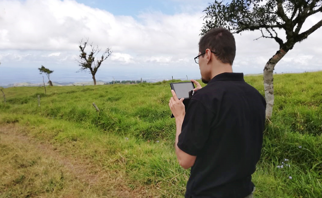
Finishing the work this fast was a result of an amazing field crew equipped with the Mobile Data Collection app. The app allowed the field crew to collect data with custom mobile forms even when offline. Here are a few pictures of the field crew using the app.

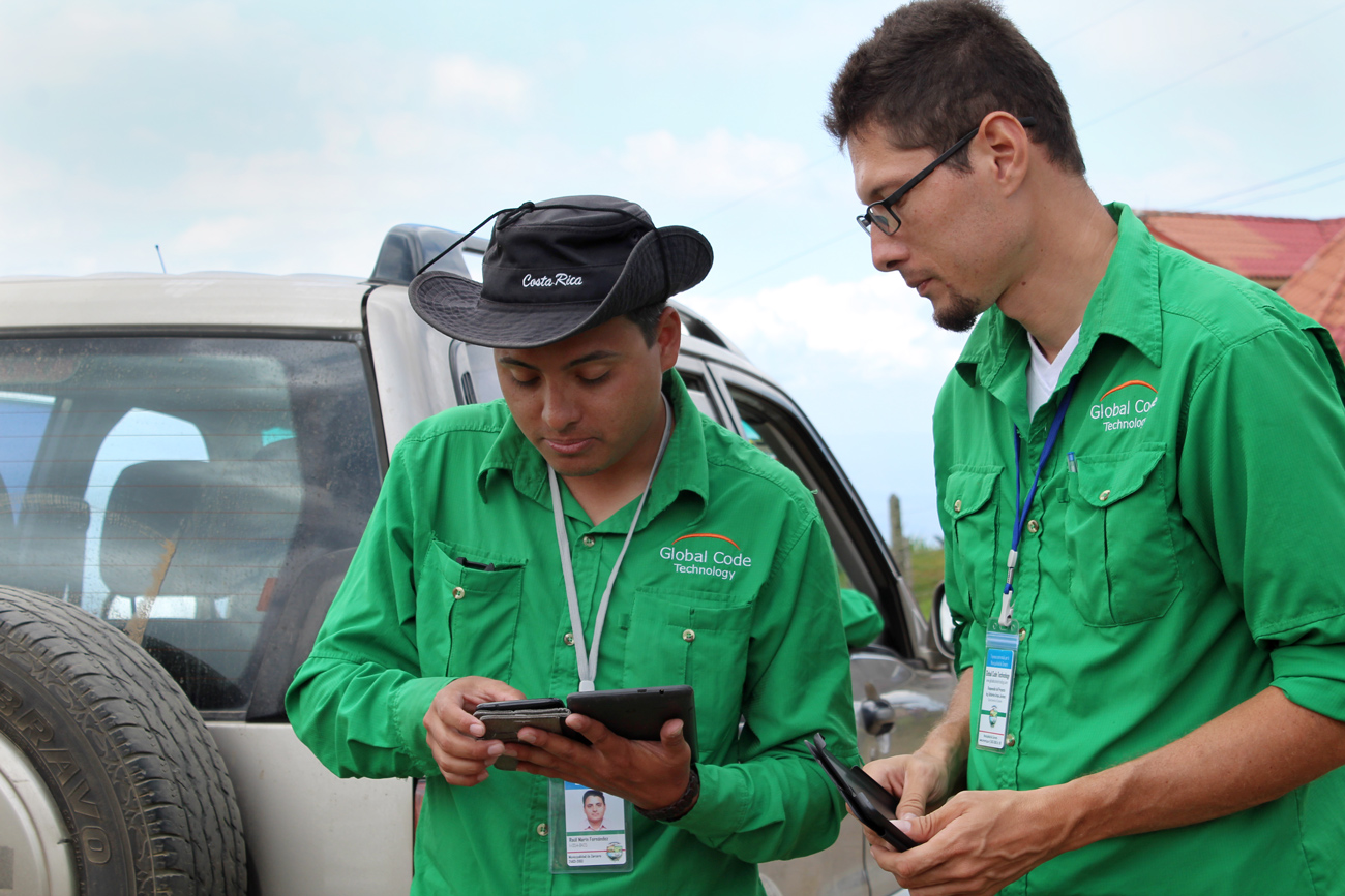
The app is really simple to use and a lot more user-friendly than a field GPS controller. It’s also easy to deploy to a large number of field surveyors. The user can quickly download the app, choose the project and immediately start collecting field data.
Now let’s get to the exact field workflow:
1. Deploy licenses to the field crew
The project manager assigns the MDC licenses to all surveyors. They download the app and login with their username and password.
2. Create project in Mobile Data Collection Portal (MDCP)
The project manager uses the MDCP web app to create the collection form. There are many field types to choose from when building forms, like read-only fields, lists, dependency fields, photos, voice recordings and many more. Get more details about collection forms here.
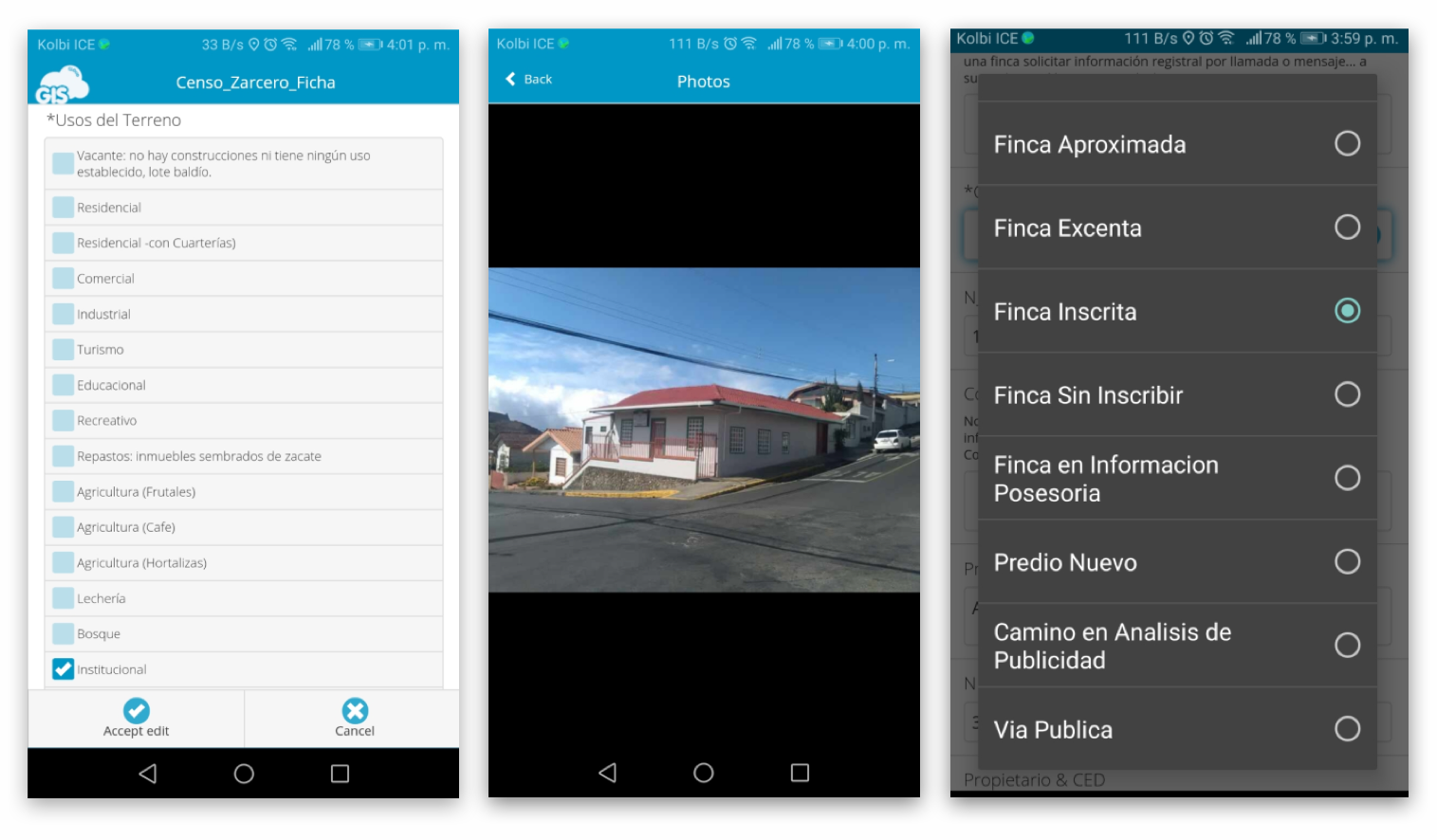 Mobile Data Collection form
3. Field data collection
When the form is completed the field crew can start to collect data. Note that the MDC app works online, offline and in bad GPS reception areas, where you can tag the location with the pinpoint tool. For projects that require higher precision there’s always an option to combine the MDC app with a GPS receiver.
4. Overseeing the progress of the survey
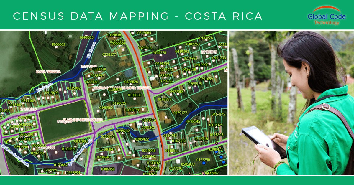
As soon as the GCT team collect the field data, it populates a map in the Map Editor. This way a supervisor can track how the survey is progressing.
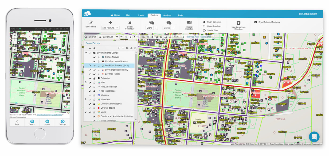 Map view in MDC app and Map Editor
The MDC form that GCT designed had more than 35 fields. The form allowed the field crew to have preloaded information, so they just had to check the answers given by the landowner. The form was designed to be as user friendly as possible to minimize potential mistakes.
One example of the data the Global Code Technology team gathered was legal and physical information about the status of the buildings, construction materials, and the existence of various amenities like pools, soccer fields, playgrounds, etc.
A complete list of the data the Zacero municipality needed:
- the states of the properties,
- road access,
- topography,
- the ground level,
- use of the land:
- commercial use,
- recreational use,
- agricultural use or
- private use
After two months of fieldwork, it was time for the next part of the project. They needed to create several cartographic products and reports that the Zacero municipality requested.
Creating cartographic products with QGIS and Map Editor
To create cartographic products like map reports and housing census files, the GCT team used QGIS, an open source desktop GIS software.
First, they needed to export the field data collected with the MDC app using the Map Editor web app. It allowed them to export maps with no effort and upload them to QGIS. The further data editing and analysis were all done with QGIS. Note that it’s possible to edit maps with the GIS Cloud Map Editor.
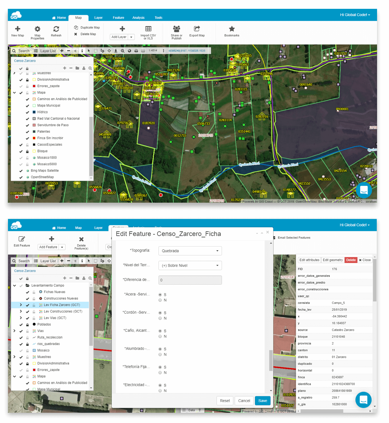 The housing census map in Map Editor
They also could have uploaded the data to an interactive and customizable online Map Portal. It would allow them to present the housing census data to the municipality without the need to create multiple maps and products. Uploading maps from QGIS to Map Portal is easy if you use GIS Cloud Publisher for QGIS plugin. Currently in beta, the plugin will be released soon for general use, allowing QGIS users to publish their maps online. The plugin basically syncs your QGIS map with the map published on the Map Portal or Map Editor. There’s also a Publisher for ArcMap you can download for free.
Global Code Technology explains why they used the GIS Cloud platform
The complete GIS Cloud solution that GCT used for collaborative mapping covered all the needs and requirements of the municipality.
The GIS Cloud platform is agile, dynamic, secure and intuitive. The apps have all the tools anyone can need to explore maps in the field like Search, Layer list, Zoom in, Zoom out, Area selection, Zoom to current, Google Street View, Measuring tools, Jump to Coordinates, etc.
– Global Code Technology team
Also, the pricing and the convenience of the Map Editor, Map Viewer and Map Portal enabled the Municipality to significantly lower the cost of the whole project.
All in all, the data collected will help the decision makers to understand the needs of the Zarcero Canton citizens. They’ll use the information gathered to distinguish the relevant priorities and distribute resources in a much more efficient way and obtain a better and more proactive municipal management.
Having trouble with your mapping project? Try out the GIS Cloud Free Trial. You’ll have 30 days to test the apps and see if they fit your field workflow. If you want someone to show you around and propose a possible GIS solution contact our sales consultants.