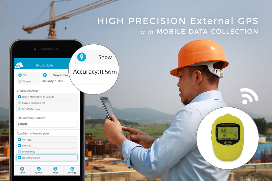
In industries like utilities and insurance, the project workflow demands both a solution with high precision capabilities as well as a solution for attribute data collection. To get rid of paper forms and keep the high-precision you can combine the Mobile Data Collection app with your high-precision GPS device.
When performing field data collection, accuracy is the number one requirement when it comes to assuring the quality and reliability of the location data. Most specialized industries are using expensive technical solutions for mapping, which require further investment of time and money for educating the field workers. Due to high costs, many companies are turning to new technologies for cost-efficient yet accurate solutions.
Doing it the old way
When collecting data in the field using only a high-precision GPS, it’s necessary to post-process the data in the office for further analysis. The data needs to be set in the right GIS format (SHP, KML.. ), the coordinates may need to be translated, and the data needs to be stored in a GIS database to perform the analysis. It is a lot of work that you can automate with the right combination of tools.
The new project workflow
Combining the Mobile Data Collection App with high-accuracy GPS receivers you can improve fieldwork efficiency while maintaining high precision. There is no need for paper forms or post-processing, the workflow is entirely automated.
Learn how to set up the workflow and connect the MDC app to your GPS receiver.
1. Create custom forms
The MDC app administrator creates a custom form, which is a structured GIS database where alphanumeric and numeric data is stored. When you’re collecting data using only GPS receiver, the data may need to be transformed, translated and then stored in the database. With MDC, you can create a form in a matter of minutes, without having to format the data manually.
2. Define attribute settings
When you create a form, you can define different settings for form fields. You can set up the dependent fields that only show if a specific rule is satisfied. Defining default and persistent values can significantly increase the efficiency of field workers. For example, if a user is approaching an electric pole, using the Autofill option allows the field collector to fetch whichever attribute details are appropriate without reentering the same values again.
3. Set up the GPS receiver?
Here is a step by step guide and a list of GPS receivers compatible with Mobile Data Collection app (supported on Android and iOS devices).
Procedure for device setup:
- Download and install Bluetooth GPS app on your device.
- Enable Developer settings in General settings. Enabling developer settings is described here.
- Enter Developer settings and turn on the Allow mock locations option.
- In the Bluetooth GPS app enable the Allow mock locations option and connect to the external GPS device. It might take a few moments.
- When connected you are ready to start collecting field data with the MDC app.
List of compatible GPS devices with MDC
- Juniper systems Geode Submeter Receiver
- GNSS Systems from Trimble
- Eos Positioning Systems
- Bad Elf GNSS Surveyor
- Trimble Catalyst
- Stonex
If you want to try out this setup, download the Mobile Data Collection for free and connect your GPS receiver.