Lack of affordable housing is a growing problem in California. Combined with the severe droughts that have afflicted the state in the last few years, this problem only grows worse for the residents in areas such as Tulare County. To alleviate this problem, organizations such as Self-Help Enterprises (SHE) are continually working together with low-income families to build and sustain healthy homes and communities. Read a case study on how GIS Cloud helped Self-Help Enterprises in constructing a new water distribution system in East Porterville.

We talked to Jessi Snyder, a Community Development Manager at Self-Help Enterprises, who told us more about the projects they are currently doing. Jessi is the project manager for the East Porterville project. She supervises the people who are in the field, collecting data, interacting with homeowners, and helping with the work of installing water lines and destroying wells. She manages the contractors and the data that is collected in the field.
In California’s recent four-year drought, thousands of rural residents lost their residential water wells to falling water tables, leaving families without drinking water and sanitation. One area that was severely hit was the unincorporated area known as East Porterville, adjacent to the City of Porterville in southern Tulare County. SHE was a project partner in the enormous effort, led by the State of California, to construct a brand-new water distribution system to serve this area that was previously entirely dependent on individual private water wells. Other project partners included the City of Porterville, who would own and operate the system; CA Department of Water Resources, CA State Water Resources Control Board, County of Tulare, and several other non-governmental organizations.
SHE’s primary role in the project was to make the final connection between the newly installed water mains to the homes, and to have the old wells destroyed following the agreements made between the City of Porterville and its new customers.
The tools they needed
With over 750 new connections between water mains and homes to be made, there was a lot of data to handle. In the first (and smaller) phase of the project, SHE crews marked the future location of water service connections with wooden stakes and flagging. This was not a strategy that held up well over the long term, as stakes would disappear or be relocated by homeowners, and the team would be left without a record of where they had been.
So, they decided that a more effective way of tracking the stakes was needed. SHE crews required a tool that would allow them to digitally record the exact position of the stakes along with additional information such as photographs or comments. This data should be available in real-time and easily shared between the field crews, office personnel, and the contractors.
In a later phase of the project, SHE was tasked with handling the destruction of all the wells that had formerly served the newly connected homes. Every possible variation of well exists in East Porterville: they are hidden in sheds, under boxes, behind houses, and beneath all manner of backyard junk. Knowing this, Self-Help Enterprises wanted to improve the coordination with their contractors and reduce the time their contractors spent on finding and destroying the wells, therefore helping to keep the overall costs reasonable.
The GIS Cloud Solution
In the words of Jessi Snyder:
GIS Cloud was brought to our attention when we were looking for a digital way to document the location of the stakes. It was a perfect fit. Our crews were able to use their existing smartphones to digitally record the precise location of the designated service connection location, then further document with photographs. We still placed wooden stakes, but no longer had to worry about them disappearing. The latitude-longitude readings were then transferred to the engineering design team, who were, therefore, able to include the locations of the new service connections in the design plans. This reduced error and problem-solving in the field during construction.

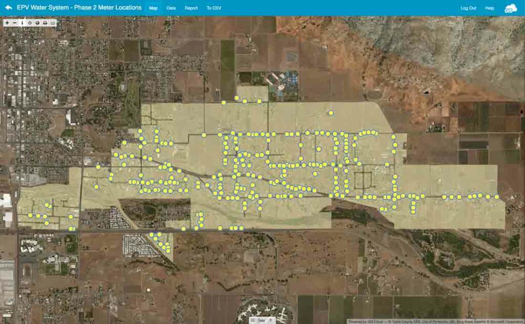
The data was collected with GIS Cloud Mobile Data Collection. It was easily visualized in the Map Editor application, where all locations of the stakes were easily shown and could be analyzed further.
When it came to the next phase of the projects where SHE needed to organize the well destruction, they returned to the field.
To keep costs reasonable and avoid wasted time on the part of the well destruction contractor, SHE crews again went out armed with their smartphones equipped with GIS Cloud Mobile Data Collection. Over the course of a few weeks, they made their way through the community again, talking with homeowners and documenting the location, condition, and accessibility of wells on every property. This data, including GPS location data, photographs, and other details, is being shared with the well destruction contractor so they can more efficiently locate and destroy over 750 private wells that are no longer needed, and which present an environmental hazard if left in place.
– Jessi Snyder.
After the success in East Porterville, Self-Help Enterprises moved on to using GIS Cloud to stake proposed water service locations for smaller drought projects in the communities of Okieville and Monson, and a replacement project for the water distribution system in Seville.
With GIS Cloud, Self-Help Enterprises got a perfect solution for managing a large scale project and having precise location information on the water distribution system, which helped them in streamlining their processes, increased efficiency, and provided the better coordination between all stakeholders in the project.
Three key GIS Cloud features which they highlighted as the most important for them were:
- Portability and the ease of use
- Simple customization
- Easy exporting and using the data
For more information about Self-Help Enterprises, please visit SHE’s website at www.selfhelpenterprises.org.
Interested in using GIS Cloud apps for your project? Sign up and try it for free.


