We bring you a 5-step workflow that can help you improve your tree inventory and increase tree inspection efficiency.

Tree Inventory and Inspection is one of the most important tasks in the workflows of Arboriculture and Urban Forestry workers. While Arborists are more focused on the care of individual trees, those who work in Urban Forestry perceive forests as a system, frequently working on large scale projects that involve a lot of planning and different policies. Both of these fields rely on having good management systems, especially when it comes to tree inventory and inspection workflows.
Data collection, visualization, analysis and publishing solutions can significantly increase efficiency in tree inventory and inspection. In forestry and arboriculture, a good overview of trees with pertaining data on a map is necessary for coordinating daily activities as well as for planning activities and maintenance on a broader scale. Most of the larger organizations that take care of trees and forests already have a GIS system set in place. It doesn’t necessarily mean that the existing processes can’t be improved further by software specially designed to provide real-time insight into the situation in the field.
GIS in the cloud enables not just real-time insight into the situation on the field, but also provides a next step for the desktop-based workflows. Let’s see how cloud-based GIS can help in making tree Inventory and inspection process more straightforward and efficient.
1. Collecting field data with mobile forms
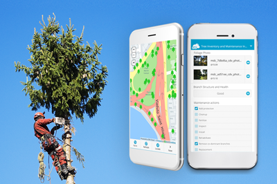
Instead of using paper reports for collecting data, the Mobile Data Collection app allows you to collect data such as tree height, diameter, trimming status, diseases and other variables. Using smartphones and tablets, you can collect different types of data including photos and audio recordings. The location of the inspected tree is instantly visible on a map. Mobile Data Collection also allows you to navigate to a particular point of interest directly from the app by using Google Maps.
The mobile system saves you a lot of time as you don’t have to input data from paper maps and forms manually back in the office while allowing you to control the data quality by selecting required fields and options for data collection.
My workflow is much more efficient when using the GIS Cloud as a basis for my quotes and work orders and collection of all field data. I can easily find the geographic data I need regardless of when it was collected and allows me to focus more on care for the trees themselves and less on keeping track of all of the data. – Sean Grant, Vivaldi Arborists (Sweden)
2. Editing and analysing field data
After the data is collected, it is instantly visible on a map and can be accessed on any device both in the field and the office. Managers and coordinators, as well as other staff, can view the data and edit it in a way that suits the existing workflows. For example, trees from a particular area, diseased trees, or those that haven’t been trimmed can be marked with different colors and filtered on a map. You can choose different basemaps (Open Street Map, HERE maps, Satellite or Hybrid Maps), create polygons and use various GIS tools that can help you to visualize data in the best possible manner.
Data visualization in Map Editor, as well as basic analysis such as heat maps or buffers, can be achieved in a short amount of time even by users who don’t have previous experience with GIS software.
3. Coordinating teams and sharing maps

To make your tree inventory workflow more efficient use GIS Cloud for data sharing and coordination between the team members, both in the office and in the field. GIS Cloud allows you to share data and maps with your staff, adjusting the level of access depending on a member’s role (user can be allowed only to view, or edit data, make reports, etc.). It can be a very useful feature when you want to share data with the external stakeholders such as other organizations, local government bodies or simply having an overview of the work done by your contractors.
When leaving quotes to customers, I find that a picture or map, in this case, speaks louder than words and with GIS Cloud I can produce maps quickly to be attached to a written quote, so there is no question about what is to be carried out. This map is also used as a base to work orders, so the correct work is carried out on the right trees (import when felling trees for obvious reasons.) – Sean Grant, Vivaldi Arborists (Sweden)
4. Publishing your map
In case you are doing a community project, as it was the case in the Maple Grove Tree Inventory project, and want to open your data to the public, it’s best to use the Map Portal.
Map Portal allows you to create an interactive GIS portal, customized and branded, and published on a separate domain. If you are already using GIS Cloud and all of your tree data is already uploaded, setting up an interactive portal takes only a few minutes.
5. Reporting
One of the most important aspects of Tree Management, especially when it comes to tree inventory and inspection projects is creating reports from the field data. Instead of manually creating reports you can export a custom report with GIS Cloud and use it as a base for future maintenance plans.
Interested in learning more about GIS Cloud tools for Tree Inventory And Inspection? Contact our sales consultants or sign up to the GIS Cloud free trial.