Digitizing the process of field data collection and infrastructure data management utilizing the GIS Cloud platform, Liburnian waters achieved a multilevel collaboration with local governments, increased their data accuracy, and reduced job timeframe by eliminating paper forms.
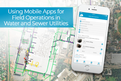
The implementation of field inspection via surveys on mobile phones had the biggest impact on their workflow, the solution which in time became SmartAqua application, specialized in water utility data management.
Water utility companies face challenges on several frontiers, from excruciating regulatory demands to water loss problems, as well as issues with outdated infrastructure data. The problems also emerge in the organizations themselves, most commonly because they lack strategic planning, have inefficient field operations with a lot of paperwork, or use a cumbersome system for asset management. To have a chance to tackle these problems, companies can turn to digitalization and implement sound management practices.
CASE STUDY HIGHLIGHTS
- Transforming a paper-based field workflow into a digital one
- Using GIS Cloud for data backup to meet regulatory demands
- Improving fieldwork efficiency and collaboration across the board
- Easier data management for water utility assets
- Creating a data overview accessible online and facilitating decision making
This article presents an elaborate case study from south-eastern Europe which demonstrates how to digitize field operations and implement company-wide collaboration in a water utility company. The study shows in what way the Liburnian Waters (Liburnijske Vode), a water utility company in Croatia, improved the process of collecting and managing water infrastructure data using the GIS Cloud platform. They also managed to increase their efficiency and save time on maintaining water utility infrastructure, hydrants, manholes, water meters, etc. (We already wrote about them a couple of years ago here.)
SOLUTION ENABLED:
- Digitalization of field operations using the Mobile Data Collection app
- Bridging the gap between field and office workflows
- Water utility asset management in the cloud
- Effortless compliance with government regulations
- Project monitoring in real time
- Accessibility of data to the public
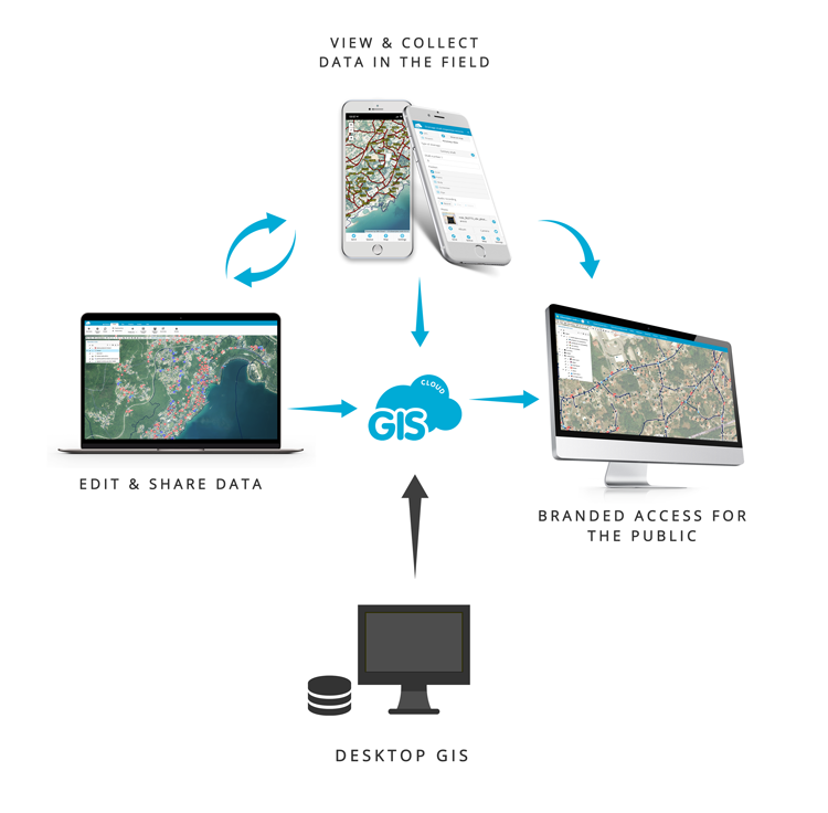
The digitalization of infrastructure data allowed them to have maps and inspection data available to anyone in the organization at any time, and accessible with mobile apps. Data was also published online through a Map Portal, which made the data public and open for collaboration with local governments and citizens. This article will demonstrate the impact digitalization can have for a water utility company from a field operations point of view, and other benefits resulting from GIS Cloud system implementation.
Liburnian Waters Company and Their Challenges
Liburnian Waters are a water utility company in Istria, the western part of Croatia. The company is in charge of the water supply system maintenance, sewage system, water quality control, and water purification for four municipalities, including the City of Opatija. They also provide easy access to water and sewer infrastructure data to local government units. The company brings drinking water to approximately 29,000 citizens with current water coverage of 99%.
There were three segments the company wanted to improve with digitalization:
- Field operations and collaboration
- Data and team management
- Regulatory compliance
The primary challenge was to improve communication and collaboration in the company while reducing the paperwork involved in field inspections. At the same time, to facilitate collaboration with external stakeholders such as local governments and citizens. Extensive paperwork and paper maps often included outdated information, leading to a slow data collection processes and a slow flow of information between their employees or third parties.
On top of that, Liburnian Waters had a priority to comply with regulations by storing their data to a secure location and creating a backup of infrastructure data. That is why they needed a solution for a secure backup of their spatial data, as well as the system allowing to easily update information linked to spatial data, which is changing on a daily basis. What played the most essential part in solving the issues mentioned before, was extending from the desktop environment to the cloud, and the digitalization of the field operations workflow and data management.
The Old Paper-based Data Collection and Data Management
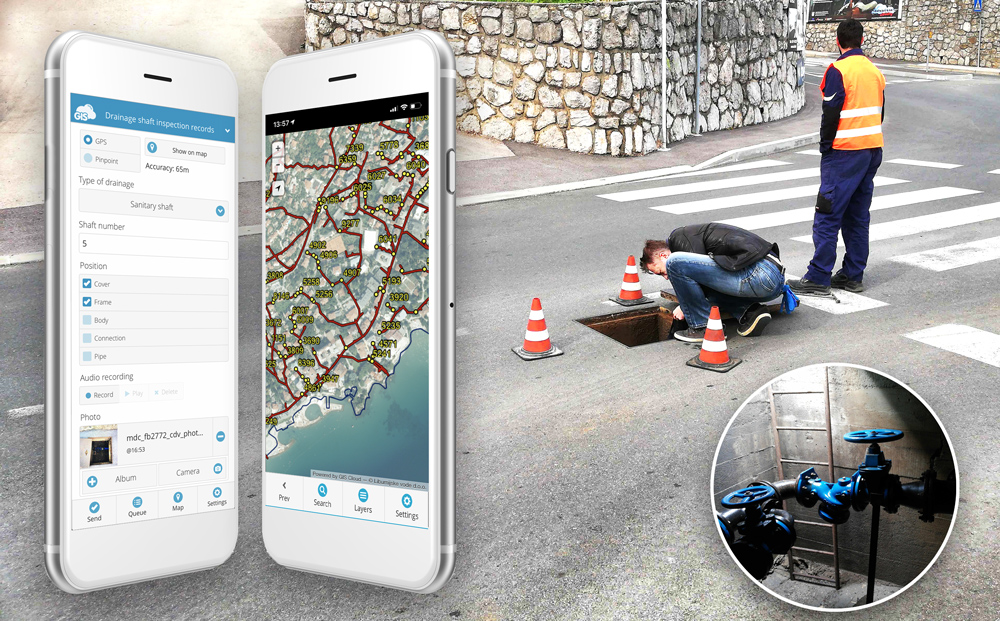
Liburnian Waters were using paper in every segment of their field workflow as well as in the office. The daily workflow started with printing inspection forms and maps of the survey area. The field crews would then go on to record the locations of assets with handheld GPS devices and perform inspections. Later they would return to the office and transcribe the data to ArcMap software. This was a typical paper-based workflow with many drawbacks like illegible inspection forms, inaccurate data, uncredited asset photos, lost paper forms, and so on.
Although the company was using ArcMap, some of the infrastructure data was still stored as paper maps and paper inspection forms. It made data management extremely inefficient, and data sharing slow. If a municipality or some other company would request data, it took a lot of effort and time to get it. Also, making a backup of data for regulatory compliance was hard to address with the data situation at that time. To solve this problem, Liburnian Waters decided to store their data not only on their desktop, but to also transfer data to an online solution, and run their field operations and data management in the cloud.
Designing the New Digital Field Workflow
To make improvements for field operations, data management, achieve collaboration and meet regulatory requirements, the company needed to implement a new field workflow and data management system.
The first step was to have all data in digital form and to bring it to the cloud to meet regulatory demands. This meant transcribing the part of data that was still in paper form as well as assembling the geospatial data. The Liburnian Waters were already using ArcGIS desktop solution, and this meant that the existing data needed to be transferred to the cloud in some way. That was easily done with the Publisher for ArcMap, a plugin that enables a user to transfer data to GIS Cloud. This provided the company with a reliable backup system accessible from anywhere.
After they made sure that everything complied with the regulations, Liburnian Waters started working on improving their internal processes and collaboration.
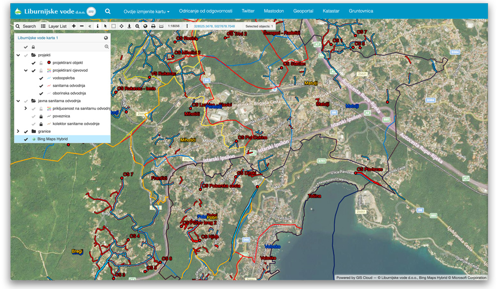
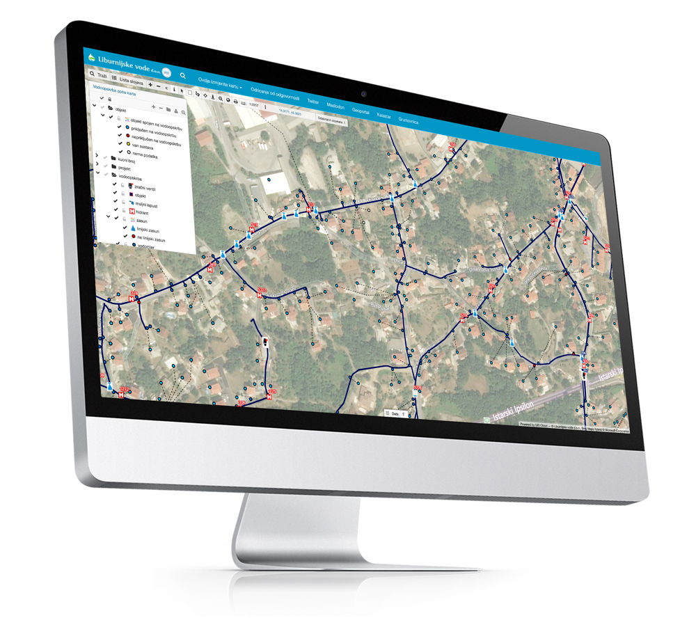
Field Data Collection and Data Publishing for Public Access
The data was now situated in the GIS Cloud, and it was time to prepare the system for the new field data that would start coming in from mobile forms. They used the GIS Cloud web app to set up data collection surveys and link them to corresponding map layers. For example, the hydrant inspection survey was linked to a map layer that contains hydrant locations and inspection data. The custom survey was then shared with collectors in the field, assigning them permissions to collect new data or update existing data from the field. The GIS Cloud web and mobile apps also provide a real-time overview of the entire water utility infrastructure.
The field workers would take their smartphones and install the GIS Cloud Mobile Data Collection app, find the survey on hydrants shared with them, and start filling in the data entry forms regarding a specific asset (eg. a hydrant). This allowed them to quickly and accurately collect field data and perform inspections (even when offline), at the same time saving a ton of paperwork.
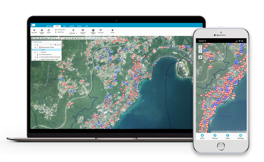
The data instantly appears in the GIS Cloud web and mobile apps as soon as it is collected, allowing the managers to edit and review the data in real time. More importantly, the application was easy to use and didn’t require any specialized training for their field crew.
GIS Cloud enabled our employees to add different types of data such as sanitary network cleanups, inspections, and water shortages directly from the field.
Siniša Čulić, GIS Officer in Liburnian Waters
The mobile apps also allowed easy access to spatial data using smartphones and tablets with different levels of permissions (view, edit, and collect). That was especially useful to management as it allowed them to monitor the situation at any time regardless of the location or the device.
To make data accessible to the citizens, it was published online through a branded map interface, which allowed citizens to determine whether their homes can be connected to the sewerage system.
To sum it up, the Liburnian Waters implemented GIS Cloud to introduce collaboration with coworkers, local government units and citizens, digital data collection and field inspections, an infrastructure overview, fast maintenance, and planning.
In words of Siniša Čulić, GIS officer in the Water Supply and Drainage department:
GIS Cloud enables collaboration between our company and local government units. Our management now has an overview of existing water infrastructure and drainage data on their smartphones while in the field. Moreover, our employees are using digital forms to enter information about sanitary network cleanups, field inspections, and water supply shortages. All data can be monitored from any location – with GIS Cloud Map Viewer; those who need accurate information now have a way to access it quickly and efficiently.
The Results After Digitizing the Company Workflow
The new field data collection process improved the company’s productivity and reduced the time needed to collect the data (field inspection and maintenance, adding a new sanitary network, facilities, drainage, and water shortages data).
All data is now available online to the office crews and management enabling them to plan their operations and prioritize tasks with more efficiency than ever. It also helped them to collaborate with local government units and citizens giving them access to different segments of spatial data.
With the expertise and services of Smart Cloud staff, the regional GIS Cloud partner, Liburnian waters quickly implemented the entire system allowing them to transform their workflow in no time. The GIS Cloud mobile apps are user-friendly and didn’t require any specialized training for the field crew. The new solution significantly improved their coordination and communication.
![]()
Encouraged by the excellent results achieved with GIS Cloud, Liburnian Waters are continuing to improve their business processes by ensuring the accuracy of collected infrastructure data.
Siniša Čulić listed the main reasons to use cloud software in water utilities:
- Intuitive platform for collaboration with people within an organization, as well as with stakeholders from local government and citizens
- Reasonable cloud service pricing in comparison to alternatives
- Easy-to-use and doesn’t require additional training or IT resources.
SmartAqua: Solution for digitalization and fast recording of field data in water supply and drainage
After extensive experience working with water supply companies and following the trends in water utility industry, which began to acknowledge the benefits of digitalization versus the paper-based workflow, GIS Cloud partners Smart Cloud joined forces with Jurica Kovač (Aqua Libera), an independent consultant with 27 years of experience with the management of public water supply systems, to surpass industry challenges.
Together they launched SmartAqua, a solution built upon the GIS Cloud platform, specialized for the needs of water supply and drainage systems. This system of web and mobile apps provides a structured and efficient way to digitally record water losses, making data instantly available to managers, which results in efficient workflow organization and fast leak repairs.
SmartAqua is equipped with digital survey forms for recording and managing data on registered or unregistered leaks, different water system assets (hydrants, manholes, valves, etc.), water meter replacement and leak repair works. Surveys can be customized according to the company’s data collection needs. Gathered data is accessible online through a map interface, and it is also represented on a SmartAqua dashboard with graphs and statistics.
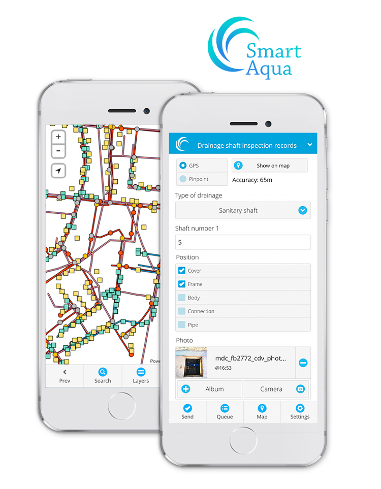
Implementing SmartAqua, water supply systems that have previously stored their data on paper or desktop solutions can finally have all their data gathered and managed in one place, accessible to anyone. Water infrastructure data is visually represented on a map, overlapped with all necessary information for the system, as well as images of assets from the field, as the proof of asset status.
This transformation of data sharing, accessibility, and collaboration across departments or other organizations makes an enormous difference in the water utility industry, creating a modern digital workflow that will benefit the community as a whole.
Want to find the right solution for your company? Contact us.