Many projects still run on PDFs, spreadsheets, emails, and chat photos. Maps arrive as exports, not as a living source of truth. This slows approvals and drives rework. GIS Cloud fixes the gap with a real-time live map, zero install, and predictable pricing so anyone on the team can collect, see, and report from one place.
Why this gap matters now
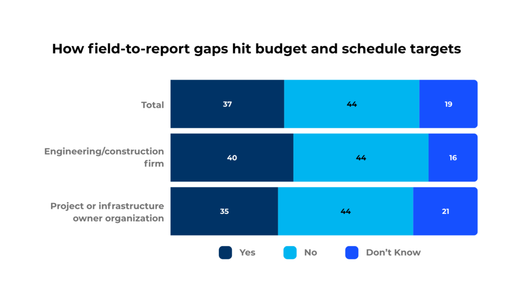
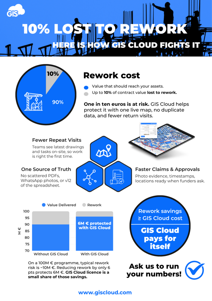
Rework costs real money. Peer-reviewed research links rework to a large share of cost growth and schedule overruns up to 22%. Even a small reduction protects budget and time. Clean, time-stamped field evidence is the fastest way to catch issues early.
Public programs face high scrutiny. A Northern Ireland Audit Office sample reported £1.94 billion in overruns across 11 capital projects, with an average delay of six years. When budgets and timelines are under pressure, one trusted system that ties photos, forms, and status to location reduces audit queries.
Teams want quick, practical wins. Industry surveys show owners and E&C firms adopting digital tools that boost productivity and go live fast. Cloud, no-install systems fit this need and scale across portfolios.
What a modern field-to-report loop looks like with GIS Cloud
Capture on site, once. Field crews use guided mobile forms and photos. Every entry is geotagged, time-stamped, and linked to the right asset or location. Barcode and QR scanning speed up asset lookup. Data quality improves because information is captured where work happens.
See everything on one real-time live map. Managers view status by site, unit, contractor, and date. Comments sit on the map feature, not in email threads. Quantity surveyors, inspectors, and PMs read the same current picture, which removes version chaos and shortens decisions.
Prove milestones, not just progress. Photos and forms create an audit-ready trail. Exports for funders and authorities include dates, users, and coordinates. Clear before-and-after history reduces disputes, repeat visits, and claim friction.
Keep delivery moving across many sites. Tasks roll up automatically. Portfolio dashboards show blockers early and highlight overdue checks or missing photos. Teams can drill from programme view to an individual asset in a click, so action is fast and aligned.
Fit your stack with zero install. Users log in and start. No desktop installs. Open APIs connect GIS Cloud to planning, ERP, and document systems. Single sign-on and role-based access keep control simple for IT and project leads.
Scale with predictable pricing. Start with one workflow, then add teams and sites. Program-wide plans remove per-site uncertainty and make budgeting clear for the year. You know the cost before rollout, which helps approvals and adoption.
See the savings story
Learn more and get started
Keep desktop GIS for deep analysis. Use GIS Cloud to run the daily field-to-report loop. One real-time live map, clean evidence, faster approvals, and less rework. With zero install, open APIs, and predictable pricing, adoption is fast and scaling is simple.
If you have a project you want to test on GIS Cloud, our Solution Consultants would be happy to talk and help you set it up.