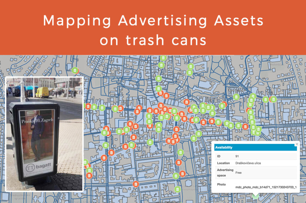
Every organization, no matter public or private, should aim to build a precise inventory of all its assets, which includes location, condition, and a photo. Information is all around us and collecting that information is a big challenge, which can be easily overcome by using the right tools. Read a use case about the mapping project envisioned and created by geography student, Martin Sinković, who also wrote this text.

Martin had a great idea on how to use mapping tools for managing assets in advertising. He created this project, mapped the Zagreb City center area, and styled the data to make analysis.
Urban space, with all its segments, serves as a fertile ground for many types of outdoor advertising. One way, which is relatively new, is placing an advertising space on trash cans. Trash cans on their own will not lure potential customers and generate revenues and profits that are essential for the business. That is the reason why asset management is the key to maintaining a high business operation level and to have an overview of all your assets in one place.
The goal of this use case was to collect information about trash cans with advertising space, including spatial data and some additional specifications. The area included in my survey was the “Lower Town” district in the City of Zagreb. The first step was to collect and map assets, for which I used Mobile Data Collection application. It enables you to easily create custom made unique forms, with as many fields as your survey needs.
Immediately after the form was created, fieldwork has begun. Using only my mobile phone with preinstalled MDC application and GPS turned on, I was able to map locations of all trash cans with advertising space in a particular city center area.
Click here to explore the map.
Besides the precise location (longitude and latitude), I filled in before determined form fields:
- street name
- availability of advertising space
- trash can condition
- date of placement and removal of an eventual advert
- name and business activity of the company advertised on that trash can
The collected data was instantly available in the Map Editor application and was visible on the map as soon as the form was submitted. Further corrections and analysis could be done using this application. You can use Map Editor for data visualization, classification, changing symbology, customizing colors and styles of icons, adding labels, designer basemaps, etc.
How to analyze data and make business decisions based on results
For a productive business environment, every organization which has some public assets should have all of those well-organized in one place. Field crews entrusted with data collection just need to have a mobile phone with installed Mobile Data Collection app to start their fieldwork. Having all your assets collected is the first step towards an efficient and organized working environment. Analysis and presentations are now within hand reach.
Using Map Editor, you can clearly present the status of your assets, for example, the availability of advertising space on a particular trash can, its condition, the date of removal, etc. Moreover, you can easily delegate your crew, assign them tasks and monitor changes in real time.
More importantly, you can control status of every trash can and act quickly if some issue appears. The main goal is to present your gathered information in the form of a visibly attractive map to the public. By doing so, the goal is to attract potential customers who will have all needed information about their future advert in one place, using your Map Portal.
This application enables you to customize interface in terms of putting your company’s logo and changing colors to brand your application. Also, you can adjust ribbon and only put items which are suitable for your certain clientele. Map Portal provides you the possibility to add more maps to your Portal, for example, together with the map of advertising assets on trash cans I can also have a map of advertising assets on tram stations and billboards. After your Portal is edited and ready, you can easily embed the map to your website and present the work that you have done.
All of this could just be an initial phase of a more complex process called geomarketing. In short, geomarketing describes any form of marketing that incorporates location intelligence to improve the odds of a particular message reaching the right consumer at the right time. This type of workflow can be used in managing various assets. Using GIS Cloud applications, you can get your business to operate smoothly, transparently, efficiently and maybe most importantly – with higher profits.
Interested in utilizing GIS Cloud technologies for asset management? Contact us or sign up here.


