If you are a company in charge of maintaining traffic signalization, taking care of utility management or simply leading a field data collection project, online GIS solution can be of great help for your workflow.
Learn how to assign your fieldworkers permissions to collect and update data about asset condition, to efficiently maintain road crossings using Mobile Data Collection App. During data collection all assets and their attributes are accessible in Map Viewer and Map Editor in real time. Now you can easily optimize maintenance process without losing extra time or money.
This use case is written by a geography student Josip Cmrečnjak who also envisioned this project, created the form and collected the data necessary to perform asset maintenance.
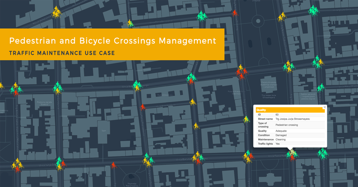
Traffic system in urban areas is often quite complex, and it is hard to keep track of entire infrastructure and maintain high quality of all roads, traffic signs etc. Josip decided to showcase a use case focusing on horizontal traffic signs, that is pedestrian and bicycle crossings, in the Zagreb City center. The project includes the area between streets Savska, Ilica and Draškovićeva, where many pedestrians and cyclist pass every day.
When lacking in spatial data, fieldworkers have difficulties organizing asset maintenance
Maintenance of pedestrian crossings is important for the safety of traffic participants, but it also does a lot for the city image. For example, faded crossings, vandalized vertical signs, and damaged bicycle paths send a bad message about the city management and city itself to tourists, but also to local people. The central problem of a complex city traffic management is the lack of current infrastructure data for minor streets. Without complete and updated information it is challenging to assign tasks to fieldworkers and optimize repair process of all important damages. In terms of space and time management, when lacking in spatial data, companies could struggle with “black spots” in traffic, issues that exist, but are not addressed. Read further to find out how to simplify traffic asset management and overcome this difficulties using GIS Cloud applications.
Make traffic maintenance more efficient with collaborative mapping
There is a simple and effective way of overcoming traffic management challenges using GIS Cloud applications. As an example, Josip used pedestrian and bicycle crossings maintenance project for this use case. His first step was to create a collecting survey form with different form fields. The best thing during this process was the possibility to choose and customize your own survey fields adjusted to the needs of your business or project. This allowed collection of the most relevant data, at the same time ensuring the data is collected correctly, without missing information. After quick and simple form making, project was ready for data collection. With Mobile Data Collection application and GPS turned on, Josip walked through the streets of the City centre collecting data about the quality of pedestrian and bicycle crossings.
For this purpose, he used his own survey with the following form fields to gain information linked to spatial data:
- type of crossing
- street name
- quality
- condition
- maintenance needed
- photo.
Of course, it was also important to mark the correct time of data collection to have accurate information on the last inspection of each crossing. Using the app, Josip photographed every crossing to have real insight into the current condition of assets, which can also be helpful to project managers aiming to improve road infrastructure. Furthermore, some crossings should have priority for maintaining, such as those without traffic lights, posing a danger for traffic participants. That is why Josip also included this information his my project. He wanted to show how we can include different attributes to easily classify the data and then decide on repair priority according to certain conditions.
This use case is only one example of how Mobile Data Collection can be used in various projects, as a crucial tool to gather data, make inspections and manage field crews to optimize their daily workflow.
Click here to open and explore the map.
In a very short time Josip succeeded to map more than 200 crossings in the project area, including relevant information about their status. With more fieldworkers, a large amount of field data can be collected without losing precious time or funds, which can be challenging to achieve in traffic management.
After data was collected Josip opened the project in Map Editor to visualize attributes of each crossing, using different icon colors for point data, depending on crossing condition. This is a great way to track and monitor the data collection process in real time, also allowing project managers to edit data if necessary. Thanks to benefits of collaborative mapping they can act quickly and decide to send teams to solve field problems, or in this example, repaint, repair, clean or adjust pedestrian and bicycle crossings. Data is accessible to managers with editing permissions in Map Editor, but it can also be made available for private viewing to stakeholders, or any other interested parties in the easy-to-use interface of Map Viewer.
As mentioned above, cities generate a lot of potential issues which are often demanding to supervise and detect at the right time. Quality of pedestrian and bicycle crossings is just one example of traffic infrastructure challenges. Organizations or cities that monitor a significant area with different types of problems to solve, can also benefit from the GIS Cloud Crowdsourcing solution. Collecting large amount of data from a public, using anonymous reports, can be fast and convenient way to do it. If you are interested in this kind of collecting solution, you can try GIS Cloud Crowdsourcing to overcome difficulties with city infrastructure management.
To learn more about GIS Cloud for Roadworks watch this webinar recording on solutions for roadworks infrastructure and maintenance.
Start your free trial today to improve your traffic asset maintenance and management process.