For the last 8 years, Greece has been experiencing a deep recession that has brought immeasurable consequences to the country’s economy. Searching for ways to cope with the pressures local communities were facing, experts from the National Technical University of Athenns, Dr. Labropoulos and Ms. Andrianesi, worked on the GeoAid project, one of the winning projects of the GIS Day Contest 2016.
The aim of this project was to map and manage the solidarity network that has been developed during the financial as well as the European migrant crisis.
The crisis in the country has had a severe impact on per capita income and has contributed to a high unemployment rate and a lower quality of life. Since the beginning of the crisis, more than 250 000 small and medium enterprises have closed, more than 25% of the population is unemployed and more than 20% of people live under the poverty line. In addition to financial problems, as a result of the civil war in Syria, more than 800 000 refugees and migrants have come to Greece.
All of these devastating facts decreased the standard of living in Greece and created an unsustainable ex-middle-class group of people that can’t support themselves and their families anymore. The situation caused a general blackout of the State’s operations and of the welfare provisions.
The state had their hands tied and couldn’t provide help, so all of the humanitarian operations were taken over by local communities, religious groups, NGOs or even groups of individuals. They have developed an extended a solidarity network acting as a safety net for people in need, providing them with help, services, and supplies.
The GeoAid Project: mapping and managing service facilities
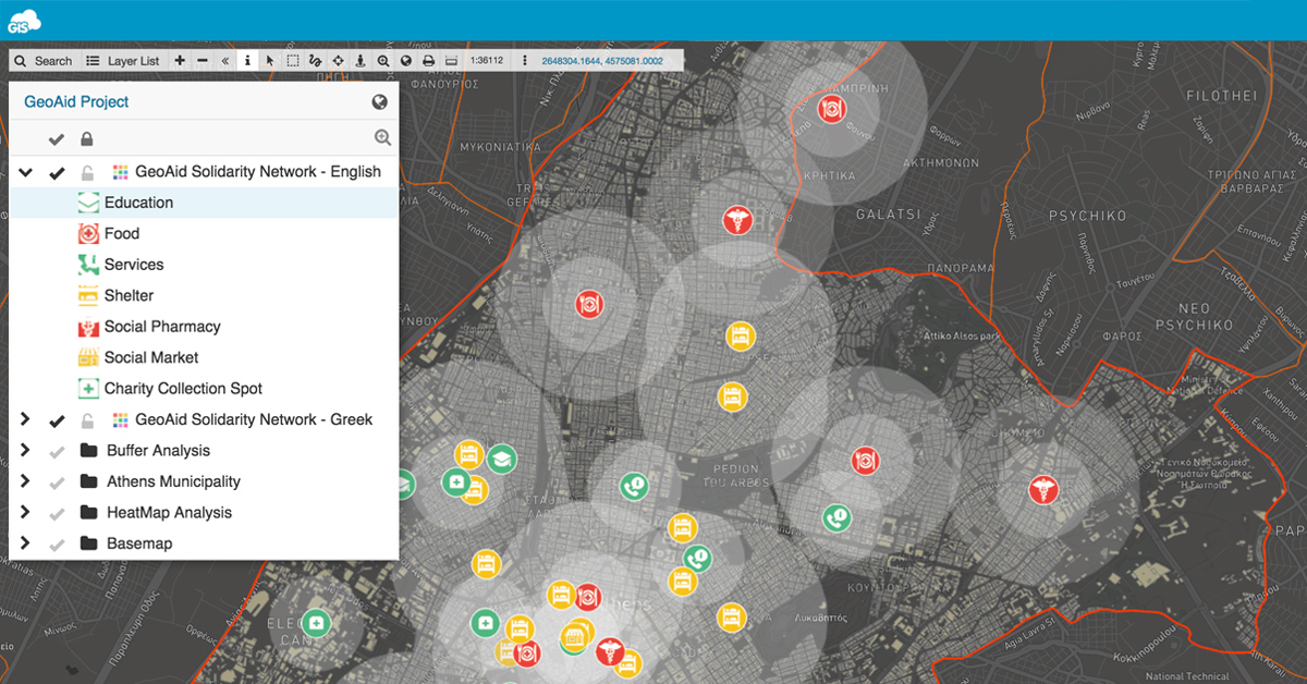
For people and families that are living on the financial and material edge, it’s essential to know the locations, particularities and the capacity of service facilities in their area. By mapping and categorizing main service locations, the GeoAid team found a way to provide a better management system of services and save precious time and effort for people that need help momentarily.
Athens Municipality was selected for the project since it’s home to 664 000 people and is hosting the majority of businesses in Greece, therefore having the greatest need for a good overview of the solidarity network. The aim of the project was to expand the solidarity network in terms of mapping the locations of shelters and showers, ‘soup kitchens’, institutions of social grocery stores, pharmacies & clinics, education centers, social markets, collection points of donations in clothing, food & medicine etc.
The project’s main objective is to facilitate the provision of services to people in need and to locate and navigate to the nearest facilities, based on their location and their special needs. The second main objective is to inform and encourage the general public of the importance and existence of such a network in order to engage them to contribute with the supplies, personal time and help.
Challenges in creating a real-time database of facilities
All solidarity network activities and operations run on a volunteer basis. The interested parties were getting informed by ‘word of mouth’, newspaper and magazine articles, and by individual organizations announcements. The solidarity network was missing basic technical infrastructure such as an official data repository and contact directory with all location information. They needed a solution that could enable the volunteers to build the database fast and to be able to add and update information about the facilities.
In addition to that, the challenge was to enable citizens in need to quickly locate the closest facility or service as well as to enable volunteers to find the locations with scarce resources in order to supply them with goods and equipment. They needed a solution that would secure access to the facilities database and a filter option to find information as quickly as possible.
The final challenge was to find a way to inform the general public of the importance of the solidarity network in order to urge them to contribute to the existing locations or expand to more locations in town. They needed a good platform to share and publish an interactive map that could be accessible to the public.
Geocoding data, using buffer & heatmap analysis to make informed decisions
In the first phase of the project, it was necessary to build an official database with all of the relevant information and contact details from the existing solidarity network. The GeoAid team found that the Geocoder app was an ideal solution to achieve this goal. It is a fast and simple tool that enables you to easily translate the addresses into coordinates and represent them on a map.
After the data was collected and formatted in an Excel spreadsheet according to Geocoder specifications, it took minutes to create an official solidarity network database that will serve as a basis for the following phases of the project.
The data had to be analyzed and visualized on the map so all the relevant and helpful information could be accessed in a matter of seconds. Part of the solution was to build spatial queries that help people navigate to the closest facility they need.
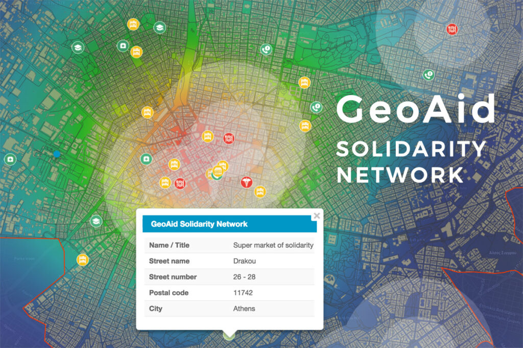
The team used Map Editor to conduct spatial analyses such as Heatmap and Buffer analysis to calculate the coverage zone of every individual entity in the solidarity network.
Buffer analysis was conducted in order to get the spatial representation of 400-meters and 800-meters radius, corresponding to a 5 minute and 10 minute walk distance, considering the average walking speed is 5 km/h. Using buffer zones as spatial queries to target the closest facility enables citizens in need to easily identify the areas with low or no coverage of facilities and to locate the closest establishments or service from their location.
Heatmap analysis was used to identify the spatial density of every individual group of facilities in the solidarity network. The visual representation shows the zones with low density or absence of facilities and zones with the highest density. This was useful for the volunteers so they can find the zones where it’s necessary to expand the solidarity network.
A Public Map Portal as a final result
Finally, in the last phase of the project, the goal was to inform the general public of the importance and existence of such a solidarity network and to enable the citizens in need the access to such information.
Explore the details of the GeoAid solidarity network viaGeoAid Map Portal.
The GeoAid team found the easiest way to share the information with the public through Mobile Map Viewer and Map Portal applications. With the Mobile Map Viewer, you can view and access shared or public maps on any device in real-time. The app is optimized for non-professionals and users can easily navigate to their real-time location to target the closest entity in their zone. To reduce the noise of irrelevant data, the user can filter the data and select only the entity categories of interest.
The project operates on a web-GIS platform such as Map Portal. You can build a custom interface and have a public overview of the data. You can access the map portal through smartphones, tablets, PCs & laptops and even stations with touch-screens in central locations. This should help increase the visibility of the project and possibly inspire people to expand the solidarity network.
Importance of GIS solutions in humanitarian actions and operations
Over the past years, the importance of GIS solutions within the community has been recognized as a key component in humanitarian actions and operations. The primary mission of those actions is to target and help the right people at the right time. Using GIS solutions can help NGOs and other stakeholders in planning and directing operations and respective logistics. The use of GIS technologies increases the effectiveness and efficiency of volunteers in the field. The GeoAid project is the perfect example to show how GIS Cloud mapping technologies can be used as a powerful tool for humanitarian aid operations.
Interested in trying GIS Cloud solutions in humanitarian aid projects?