
Online GIS is becoming an essential platform for pest control and management worldwide.
Collecting data, creating maps, and conducting geospatial analysis on a large scale helps prevent the spread of pest disease. It is used to interpret and analyze patterns to understand spatial interaction between pests, soil, and vegetation affected by the disease.
GIS is also used to track monitoring actions, such as spraying programs, trapping solutions, treatment, etc., by providing accurate location information that helps with pest management decisions.
Based on the acquired data, GIS can help you predict risk assessment models for pest control and management. Identify critical intervention areas to combat the disease spread with appropriate solutions.
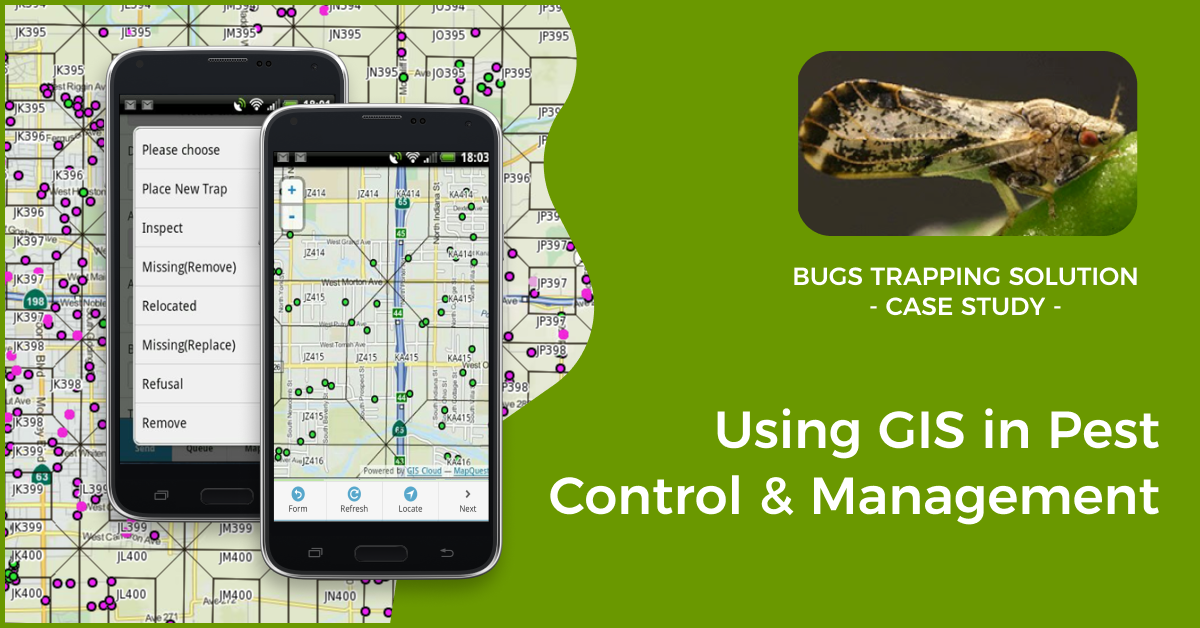
In California, USA, Tulare County had immense problems with Asian Citrus Psyllid (ACP), an invasive species of grave concern to the agriculture community. It can carry the disease named Huanglongbing (HLB), also known as Citrus Greening. All citrus and closely related species are susceptible hosts for both the insect and the disease.
There is no cure once a tree becomes infected. The diseased tree will decline in health until it dies.
Find out how our old clients Tulare County fought this invasive species with the help of online GIS.
Table of contents:
- Data Collection and GPS Challenges
- Custom Map For Monitoring Pest And Insect Traps
- Benefits Of Online GIS In Pest Control
Data Collection and GPS Challenges
Methodology and data collection that Tulare County used for the ACP survey was paper-based. This was overwhelming for field data collectors because visits to potential host trees required continuous document data entry for monitoring activities.
As GPS location in this project is a requirement, any inaccurate GPS collected data requires several trips back to the site for overview and correction. The biggest challenge was slow and inefficient editing and updating of the collected data. Tulare County needed a fast and accurate software solution that would enable them to gather data quickly and reliably.
The solution needed to have:
- Option to use statewide trapping grid (STG) for coordinating trapping projects
- Easy to use data collection solution for non – GIS users
- A tool that enables collecting and reviewing of the data on each potential host (trap type, activity action, address, tree species, multiple photos, latitude, longitude, etc.)
- A mapping tool that has the possibility of editing, labeling, and classifying the collected data
- A mapping tool that gives an overview of locations of the potential hosts with the associated information on a map
Custom Map For Monitoring Pest And Insect Traps
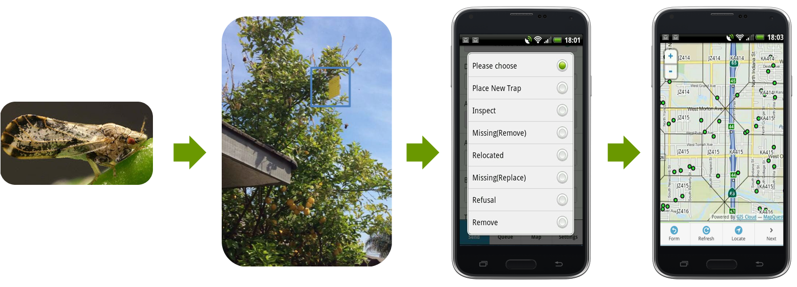
Survey methods and inspections for ACP include the placement of yellow panels, commonly known as “sticky traps“, to catch and monitor pests and insects.
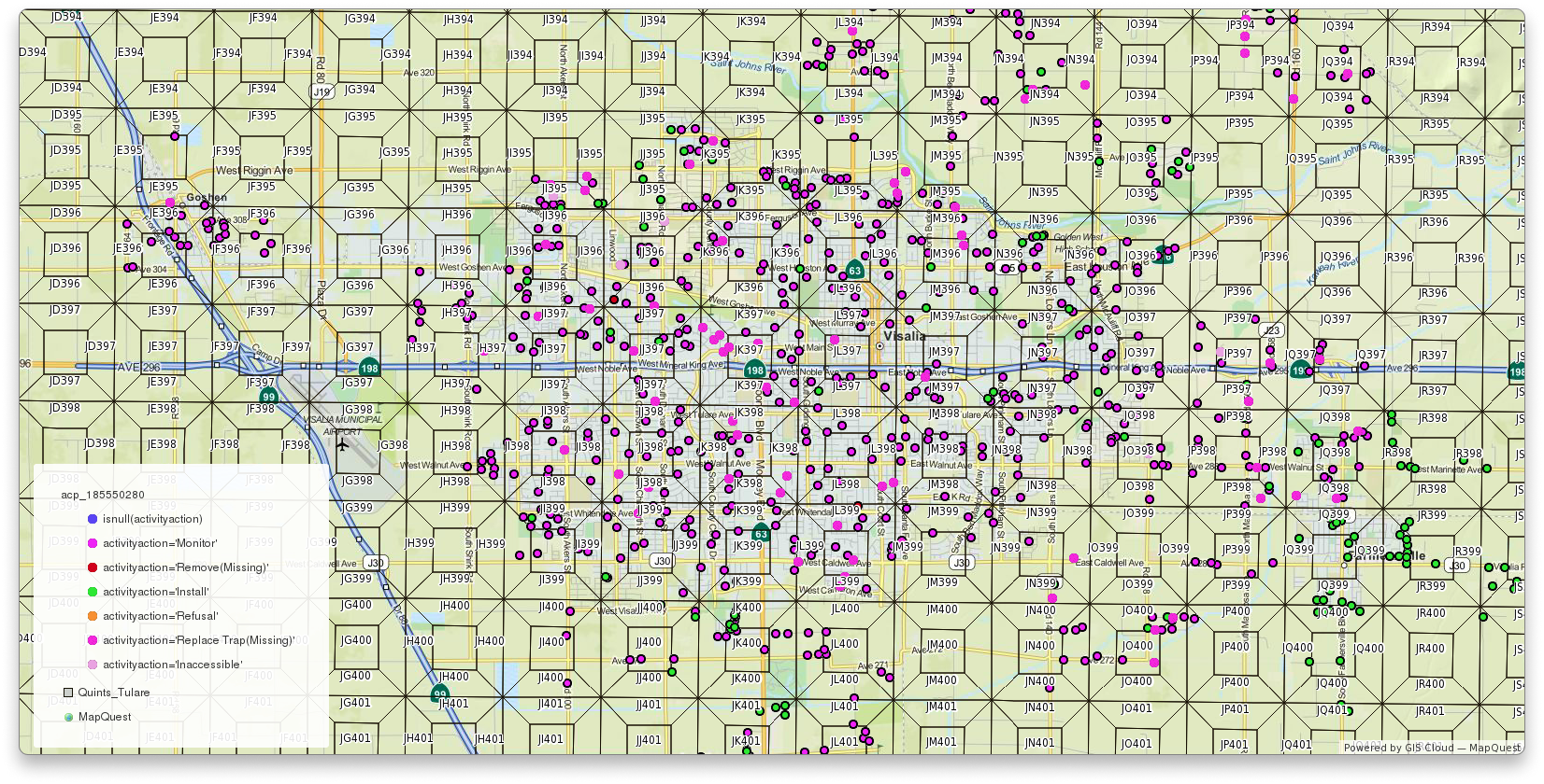
Instead of using old and outdated paper surveys, the team that collected and inspected the citrus trees by state and county could now do this with the Mobile Data Collection app. With the statewide trapping grid system created in Map Editor and divided into quints, subgrids of areas were distinctly labeled and color-coded to find the field locations quickly.
With the help of Forms Manager in Map Editor, a custom survey (form) was created for ACP trapping methodology. The custom survey helped them set up an accurate and relevant arrangement for each potential host’s data collection with the associated “sticky trap.”
There is also a neat photo database to follow up the location on hosts. If there was a weak GPS signal in the area, they used the mobile app’s pinpoint tool. Pinpoint allows you to retain great accuracy by pinpointing the location on the map.
The Mobile Data Collection app works offline in case you lose internet connection. The collected data waits in the queue for the mobile phone to connect to the internet and then pulls the data back online.
The project was shared with different field collectors, who could then simultaneously collect data in one map. Once the users were in the field, they accessed the map with the connected form on their mobile phones or tablets.
Collected data was sent in real time to the lead account in the office. The lead project officer could keep track of the users and the data and make informed decisions on the spot. This interactive collaboration and communication helps with accessible control interventions and prevents pests from happening in the future.
Additionally, Tulare County customized their map in Map Editor, where they classified the collected data based on the project’s activity action.
Each point on the map was presented with a different color, indicating that the action was completed or needed further activity action or surveillance.
Benefits Of Online GIS In Pest Control
Using Online GIS as pest control and management platform provides descriptive and accurate, easy-to-use data for any given operations. It is a comprehensive solution. You can create custom surveys, share them with different permissions to the team and collect field data online and offline.
Options to analyze, review and update the collected data in-office and share the results with your team or stakeholders privately or publicly in your map will help you make better financial decisions.
GIS Cloud is a powerful mapping platform that supports different data formats (statewide trapping grid), enables classification, labeling, and editing in real time!
Be more effective, optimize your pest control response and management.
Contact our Solution Consultants to help you set up a desirable, customized GIS Cloud solution for your specific needs and workflow!
Also, Sign up for the 14-day Free Premium Trial!