
Ensuring safe and clean water for the people across Africa is one of the greatest problems on the continent. Water sources are often miles from towns and villages, so people are forced to spend hours each day simply finding and transporting potable water back to their homes.
In the city of Kumba (Cameroon), displaced people settled in their farms lack safe water access, and most of them and their hosts are also facing an increased risk of WASH-related diseases.
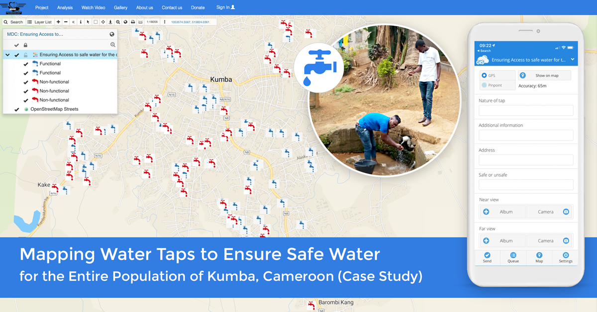
This nonprofit project is designed to map water resources using online GIS and a data collection app, to improve existing water points in Kumba (Cameroon) by making provisions of many outlets and rehabilitating the water points which are not functional, with the goal to increase access to safe potable water and improve health conditions of the local population.
Table of contents:
- Water Sanitation and Hygiene (WASH) Related Diseases, Challenges and Goals
- Collaboration between the Nonprofit Organisation and the Local Community
- Strategy and Planning to Ensure Successful Mapping of Water Taps using Online GIS
- Field Data Collection and Financial Liability of Water Consumption
- Militant Lockdown and COVID 19 Pandemic Slow Down the Project and NG4C Films a Documentary on Water Situation in Kumba
- Providing Water Access Info to the Public with online Map Portal and Pursuing Further Funding
Since late 2017, long-running tensions in Cameroon’s NorthWest and South-West regions have escalated, leading into armed conflict. Around 351,000 IDPs (Internally Displaced Persons) and 372,000 people in the host community need water, sanitation, and hygiene services.
Household water treatment is not conventional, and typically many people lack the means and knowledge to ensure safe environmental health practices. Available water and sanitation infrastructure and support distribution are therefore significantly limited.
Tabong Phillip Nucha Junior, project manager at the New Generation For Christ (NG4C) – NGO from Kumba, Cameroon, decided to apply for ourGIS Day Contest in 2019 to help his community.
Their main goal was to map existing water points and water access in the city of Kumba, Cameroon and deal with dislocated water sources and nonfunctional taps, to ensure access to safe water resources.
We have noticed the immense need for sustainable projects in the clean water and sanitation sector around the world and decided to do our part to help, so we awarded those projects with free GIS Cloud subscriptions and our support. We chose his project, amongst others, because NG4C had a clearly developed mapping strategy on how to provide access to clean potable water, which will have a great impact on the local community.
Water Sanitation and Hygiene (WASH) Related Diseases, Project Challenges and Goals
The scarce water resources and inadequate WASH infrastructure in Kumba increase financial strains on affected households in urban areas and enhances the use of unsafe water sources. Consequently, most displaced populations and their hosts are also facing an increased risk of WASH-related diseases. According to the World Health Organisation (WHO), water, sanitation, and hygiene-related conditions (WASH) are killing more people each year in developing countries of Africa.
WASH responses have primarily been through the distribution of items to enable safe health and hygiene practices among the affected populations. Water supply service repairs have been undertaken in the past. However, some of them are still in the planning process for the future, considering the small local capacity to support the distribution of water supply and its technical assistance.
The biggest challenge N4GC faced in executing this project was a lack of financial resources. They were forced to use their own monthly income to set the project in motion and provide payment for additional data collectors.
The ultimate goal of this project, to secure clean drinking water for the entire community, will be achieved by mapping existing water resources to find non-functional water taps and rehabilitate them, but also make provisions of outlets, and therefore:
- Increase access to potable drinking water
- Promote water and sanitation hygiene, thereby reducing diseases related to inadequate water and sanitation hygiene such as Cholera, Malaria, Diarrhoea, etc.
- Enable proper sewage disposal (wastewater) in households and decrease WASH-related diseases.
The NG4C nonprofit plans to achieve many valuable and sustainable objectives through this project, that will have a significant impact, not only on the entire Kumba population but also on the society in general:
- Improve the health conditions of the local population
- Reduce the risk of an epidemic caused by poor hygiene and sanitation
- Increase the availability of potable drinking water
- Water utility charge collected from the beneficiaries will help in the sustainability of these water points and the creation of other water outlets in the nearest future
- Increase experience by involving the community in the Design, Implementation, monitoring, and evaluation of the project
- Improve girls’ academic performance in schools. The time they spend in fetching water will now be directed to studies.
This kind of approach is going to empower the local community on sustainability to ensure effective usage of the water points through training.
It is also going to reduce long distances people have to walk to get potable drinking water and reduce the inequalities in access to water and sanitation.
An essential objective of this project is also to bestow a sense of ownership of public water projects, especially in terms of project sustainability.
When you increase the availability of clean drinking water to the local population, you also teach the local community how to use the water points effectively and more sustainably.
Tabong Phillip
Collaboration between the Nonprofit Organisation and the Local Community
New Generation for Christ (NG4C) is an NGO of youths from diverse backgrounds. They are young professionals who share a common vision and desire to effect change. They are an operational NGO, that is, they plan and carry out boots-on-the-ground projects to accomplish their objectives and tasks such as this one with a great deal of careful planning, communication, and local involvement.
Volunteers already carried out numerous community development projects that brought a change in the community and are continuing enabling rapid development such as road construction, coverts, blowing off drainage, schools. Bringing clean and potable water to the people of Cameroon is yet another honourable mission that they wish to accomplish beginning with the town of Kumba.
By involving volunteers and local people in the project essentials; the design, implementation, monitoring, and evaluation will increase community experience in executing development projects.
Strategy and Planning to Ensure Successful Mapping of Water Taps using Online GIS
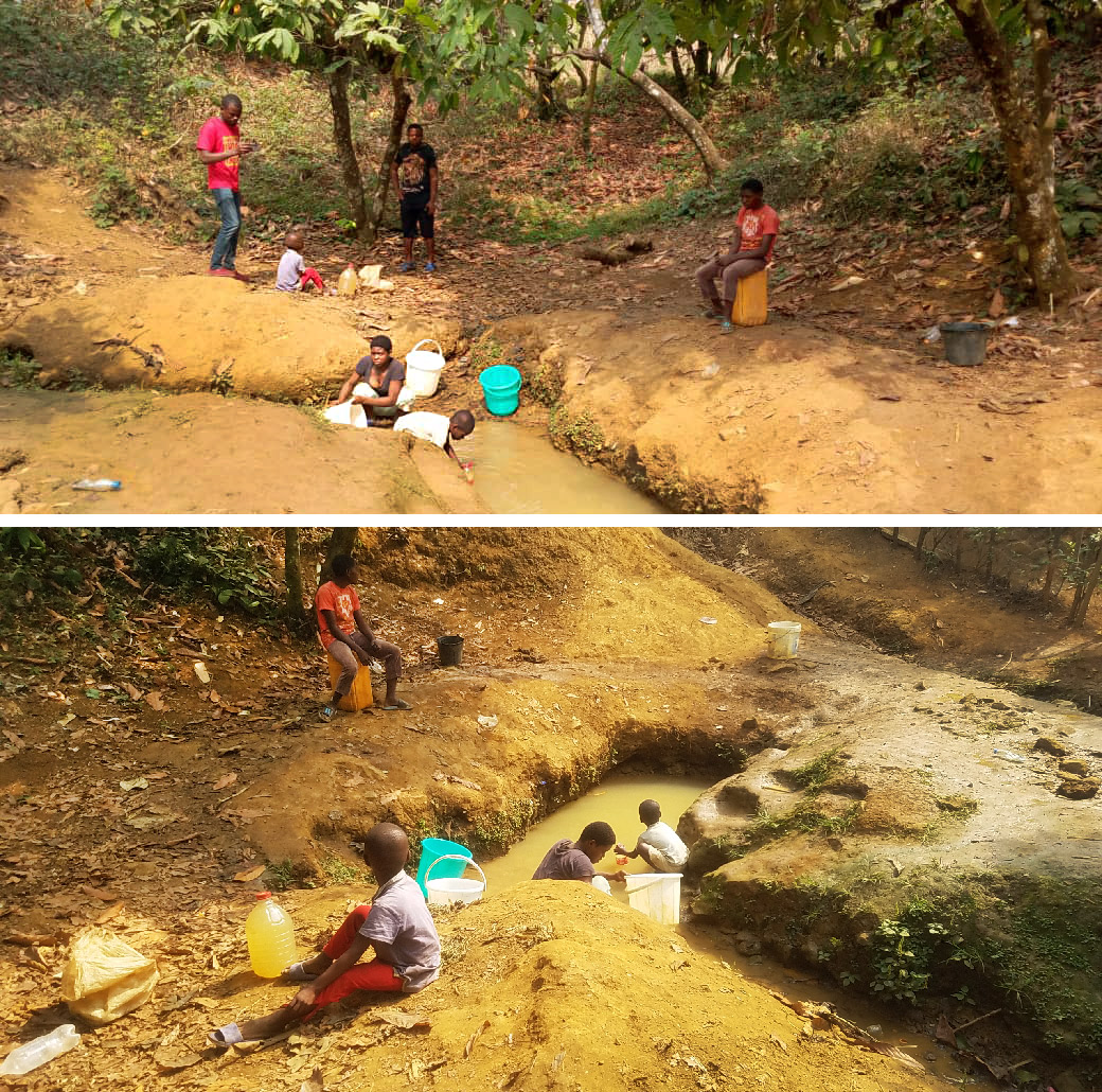
Household water treatment is not standard in the Kumba town area, and many people lack the means and knowledge to ensure safe environmental and friendly water practices. Displaced people in villages and urban areas have inadequate and unsafe access to water supply systems. This can increase financial strains and risks of using hazardous water resources.
NG4C constructed a plan divided into project phases to improve the already existing water points in this area and make provisions for many future possible outlets:
-
Data Collection and Mapping
The first phase includes a general assessment of the water supply system, WASH infrastructure functionality and accessibility to local people.
The starting point is collecting data in the field with GIS Cloud Mobile Data Collection app to map existing water resources. This phase also includes the sensitization of local population and stakeholders by understanding the local perception of water in the area and communicating a strategy between the population and stakeholders.
-
Data Analysis and Monitoring
The second phase includes the analysis of the collected data to assess the condition of the water supply system, followed by staff coordination and activities. Daily monitoring and evaluation of activities ensure success in gathering accurate and quality data to reach the desired outcome. This is important because collected data needs to correspond with its position on the map and provide accurate geo-information. With the help of Map Editor, they analyzed and monitored the course of the project.
-
Reporting and Progress Evaluation
This phase consists mostly of creating reports and evaluating the progress of the project. It is important to monitor and update adequate geo-information of the located water outlets in case of water availability changes regarding the specific tap. Teams on the field and in office need to be in sync and ready to refresh the information.
-
Launching the Map Portal
The last phase of the project is launching and sharing the public including a map with the locations and access to clean drinking water. This GIS app allows the public to search, visualize and explore geospatial data of all water locations on the map.
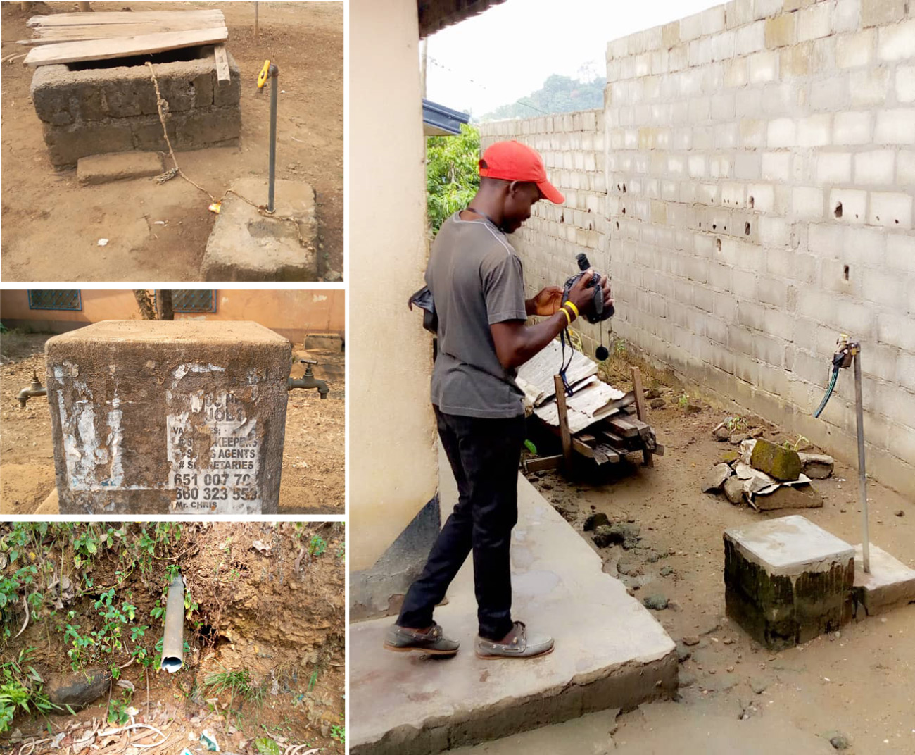
Field Data Collection and Financial Liability of Water Consumption
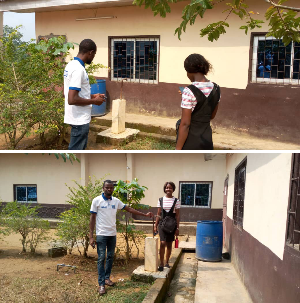
Project activities started on 23rd of January 2020 when the project manager held an orientation meeting with mobile data collectors, illustrating practical examples of how they will collect data to ensure the project moves on smoothly.
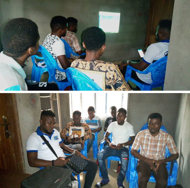
They created their own custom digital form to perform a survey on dislocated water taps and other sources.
While mapping along the city streets, NG4C discovered that the Kumba City Council had already allocated public taps beside the road to be used by the local population sustainably. Unfortunately, this strategy was not effective because the local community did not abide by the rules. People placed in charge of collecting daily fees for those carrying water were not executing their work rightly.
As a result, the City Council was responsible for paying monthly bills of consumed water to the supplying company Camérounaise des Eaux. This became an additional liability to the City Council, and unfortunately, they had to shut down the taps.
City Council gave a condition to the owners of the land where the water taps reside if these taps were to continue flowing constantly, to collect the daily water fee and meet up with the monthly water bills. This additionally made public access to water difficult since people in the community are poor and lack money.
Some of the water taps were not functional because of local political reasons, and the main pipe that supplies water to the local population is very small. Thus, the water is not distributed evenly in every home. Taps that are functional are also compromised during the rainy season, and the population is forced to rely on unsafe water sources.
Tabong is hoping that mapping these water taps will help the local government to coordinate activities and repair or construct new taps, and to the people in responsible water consumption and diminishing monthly water bills.
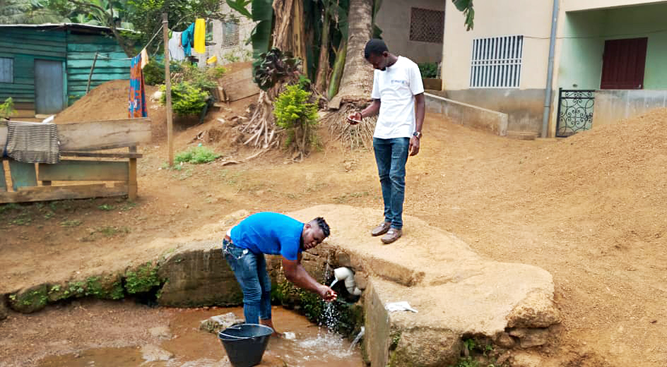
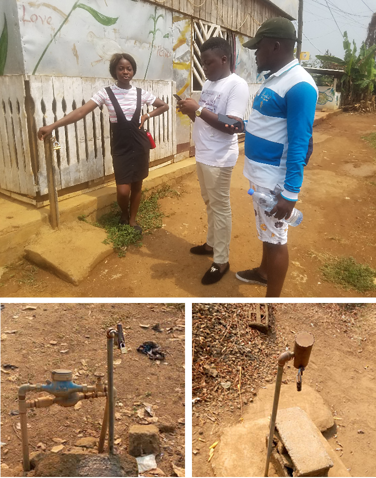
The NG4C team collected data with the Mobile Data Collection app to ensure that the project implementation is on point. It was essential to collect quality data, and with the MDC app, they adopted this process without any difficulties and started collecting data on the spot, taking notes, and recording which of the taps are in function and which are not. Data control and accuracy is secured by using required form fields and by giving collecting and updating permissions to designated data collectors. Volunteers did all of this using only their smartphones.
All activities were supervised by the project manager making sure the data collected corresponds with its position on the map.
GIS Cloud’s Offline mode in Mobile Data Collection and Offline Maps option helped the NG4C team with constant electricity cuts and lousy internet connection.
Offline collections are stored on the phone and synced automatically when back online. This was very beneficial and helped organize the field crew efficiently.
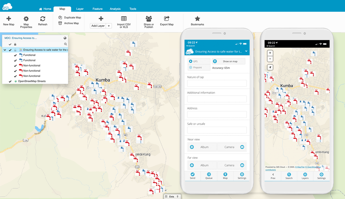
Mobile Data Collection and Map Editor Apps.
During and after the data collection process, the project manager had a great visual overview and could track the progress of the collected field data in real-time in the Map Editor. This app gave them the possibility of analysis, data editing, and sharing maps to stakeholders on the spot, replacing the outdated paperwork.
Also, Map Editor enabled them to create their custom symbology for the water taps.
Militant Lockdown and COVID 19 Pandemic Slow Down the Project and NG4C Films a Documentary on Water Situation in Kumba
While the project was ongoing in February 2020, Tabong and his team suffered a one-week militant lockdown imposed by the non-state armed groups to prevent Municipal and Legislative elections from taking place in the English Speaking Regions of Cameroon.
This further complicated the situation and postponed field data collection on this complex project.
Insecurity and violence have forced more than 400,000 people to flee their homes and continue to have serious consequences on livelihoods and living conditions.
Tabong Philip
After the lockdown, they restarted the project and filmed a video documentary in one of Kumba city subdivisions – Barombi, to portray the current water situation in the area. The video shows first-hand information from the interviews with the displaced people on the challenges they needed to overcome and shows how NG4C implemented their project using GIS Cloud apps to get results and plan further actions.
Watch the video documentary in full:
Tabong’s team needed to know what conditions these people were facing considering clean water, sanitation and hygiene while in isolation. Unfortunately, this is forcing the local people to rely on unsafe water, increasing WASH-related diseases.
In March 2020, as the COVID 19 pandemic became prevalent in Cameroon, Tabong and his dedicated team were experiencing additional difficulties, and in May 2020 project activities with regards to data collection were temporarily suspended.
First of all, they had an inadequate number of volunteers to participate in mobile data collection. They needed to recruit and pay collectors so they could effectively carry on the mapping of the project.
Also, during this crisis, the majority of citizens in the Northwest and Southwest regions of Cameroon have been reasonably sceptical about any action not related to health and food provisions and thus refused to map their taps.
Change is challenging for some people to accept, and they often resist outside activities even when a project is beneficial for them. This will, unfortunately, leave some of the taps in the NG4C project unmapped for now.
Providing Water Access Info to the Public with online Map Portal and Pursuing Further Funding
When the data collection part of the project was completed, the NG4C used two classifications in Map Editor to easily assess conditions in the field and to clearly visualize data on a map for all interested parties.
Tabong’s team created and published an interactive Map Portal, a branded GIS app for sharing maps with the public. It allows the public to search, visualize and explore data, in this case, functional or non-functional water taps. Map Portal displays the map with the data NG4C collected, where the blue taps indicate all functional taps, while the red taps indicate non-functional taps.
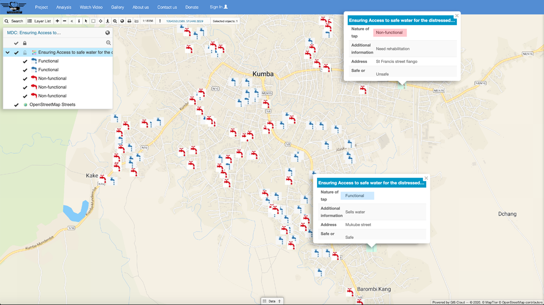
Open this link to browse Map Portal in a separate tab.
This was a huge step in helping the local community and providing visual and secure access to clean drinking water. It was also intended to assist other NGOs and the government to easily locate taps that need rehabilitation, or where to construct new taps in Kumba using the data that NG4C provides to them upon the completion of this project.
For sustainability purposes, the NG4C will be updating the map whenever a public tap is rehabilitated or newly constructed to ensure access to safe water for the local population, carried out by any NGO or the Government of Cameroon.
The availability of data will be ensured with help from the Ministry of public works, local councils and other local NGOs intervening in integrated rural and urban development within the community.
During their mapping activities and after assessing the needs of the local community of Barombi Kang in Kumba, NG4C discovered they are currently facing a high level of water shortage which is due to the inconsistency of water supply by CAMWATER, with a majority of people not having WASH hardware in their homes. They are forced to consume untreated water sources, which is detrimental to the health of the entire household and the community at large.
NG4C plans to contribute towards solving this problem by rehabilitating three nonfunctional water points and increasing the number of water outlets to ten per water distribution point. However, to achieve this, they need additional funding.
Despite all of the NG4C efforts and the help of GIS Cloud’s apps, services and technology which empowered the volunteers to increase work performance and data quality by reducing operating costs and making them more efficient, the New Generation of Christ is still faced with unfortunate financial challenges that are slowing down this project.
The NGO is in search of additional funding to be able to continue their efforts through Cameroon and introduce new approaches, and they have data to support their project!
You can also get involved by donating to the NGO on their website and aid them in their project expenses to ensure access to safe water resources in Kumba, Cameroon.
We are proud to be able to take part in this project and help Tabong and his team in providing and ensuring access to safe water for the distressed population of Kumba, Cameroon.
Are you interested in GIS Cloud solutions for NGOs and Nonprofits?
Contact us; we’ll be more than happy to give you a live demo.