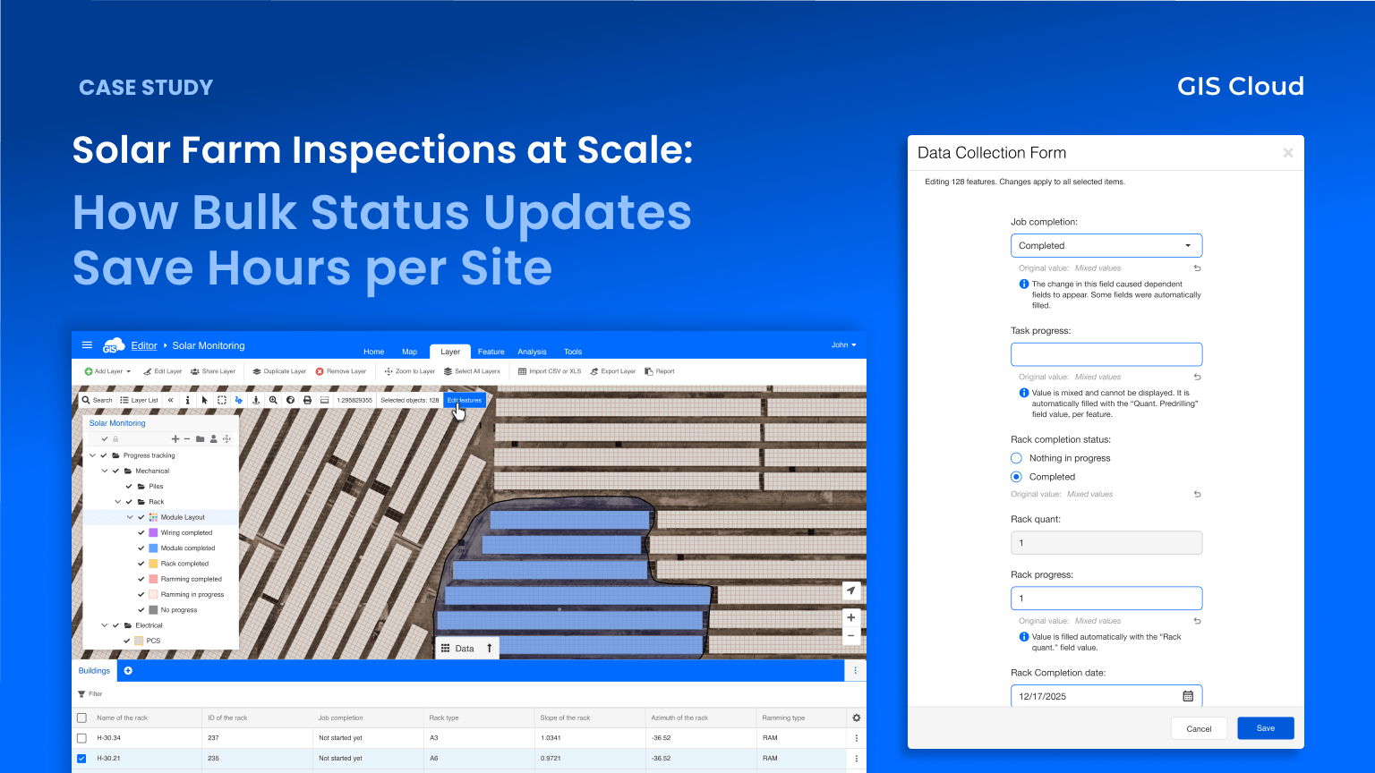
After every construction phase, inspectors needed to mark dozens of solar panel racks as “Completed”, one feature at a time. Each update triggered automations that calculated progress and filled dates, but only in single-edit mode. Also, updating each feature isn’t just slow; it’s a bottleneck that delays the entire inspection cycle. Bulk Edit changed that: select all features in the zone, set one status, and let the system handle the rest, per feature, automatically.
This is the story of how one renewable energy company went from afternoon-long editing sessions to two-minute bulk updates, with every form rule and per-feature calculation intact.
One at a Time, Hundreds to Go
As a leading renewable energy company operating across Asia-Pacific, our customer builds and operates utility-scale solar farms, sites with thousands of individually mapped components. Each solar farm goes through multiple construction phases: ramming (driving support posts into the ground), rack installation, panel mounting, and electrical cabling. Every component on every site needs to be tracked through each phase.
In GIS Cloud, each component is a map feature with a detailed inspection form attached. The form tracks the construction phase, inspection status, completion dates, and progress metrics. Dependencies between fields ensure data consistency — when a status changes to “Completed,” automations calculate completion percentages and fill date fields automatically.
The problem was scale. After completing a construction phase on a section of the site, inspectors needed to update every feature in that zone. With hundreds of components per section and thousands per site, this meant one of three things:
- Clicking into each feature one at a time. For 200 features, this could take an entire afternoon — and that’s just one status update on one section of one site.
- Exporting to QGIS for batch changes. Faster for the raw update, but you lose all form logic. Automations don’t fire, dependencies don’t evaluate, and the data needs to be re-imported afterward. The round-trip breaks the real-time workflow.
- CSV export-import cycles. Same problem as QGIS — you’re working outside the system, recalculating values manually, and hoping nothing goes wrong on re-import.
None of these options were acceptable for a company managing dozens of active solar farm sites simultaneously.
What the Workflow Actually Required
The requirements that came out of the discovery process were specific:
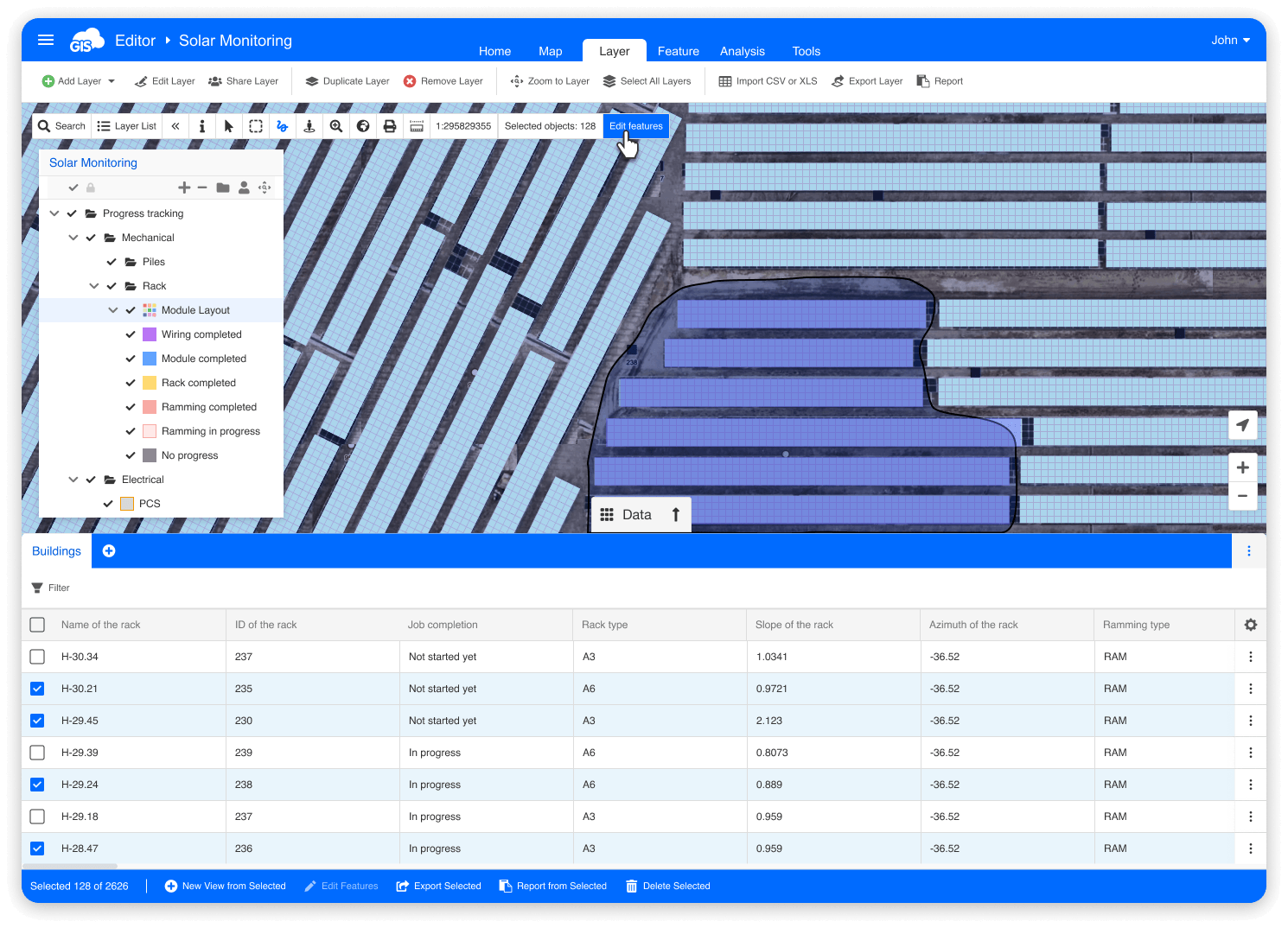
- Select features by location. Inspectors know their site. They can point to a section on the map and say: “Everything here is done.” The tool needs to support lasso or area selection on the map – not just checkboxes in a table.
- Full form logic in bulk. When the status field changes to “Completed,” the form automations must fire – filling completion dates, calculating progress percentages, and revealing dependent fields. This has to work during bulk editing, not after.
- Per-feature calculation. This was the critical requirement. Each rack has its own quantification value: area, capacity, and inspection count. When you set 200 racks to “Completed,” the progress percentage for each rack must be calculated from that rack’s own data. A blanket “set everything to 100%” doesn’t work because the racks have different specifications.
- No feature limit. Some quality-check operations involve selecting thousands of features at once. The tool can’t cap at 50 or 500.
- Review before saving. When you’re about to overwrite data on hundreds of features, you need to see exactly what’s changing before it happens. One wrong field update across 200 features creates 200 records that need manual correction.
- Mobile capability, eventually. Field inspectors work on-site with tablets and phones. The bulk update workflow needs to come to mobile, too, but the web version was the priority.
Select, Bulk Edit, Confirm: All in the Browser
GIS Cloud built Bulk Edit directly into Map Editor; the same environment the team already uses for map management and data review.
How it works for a typical inspection update:
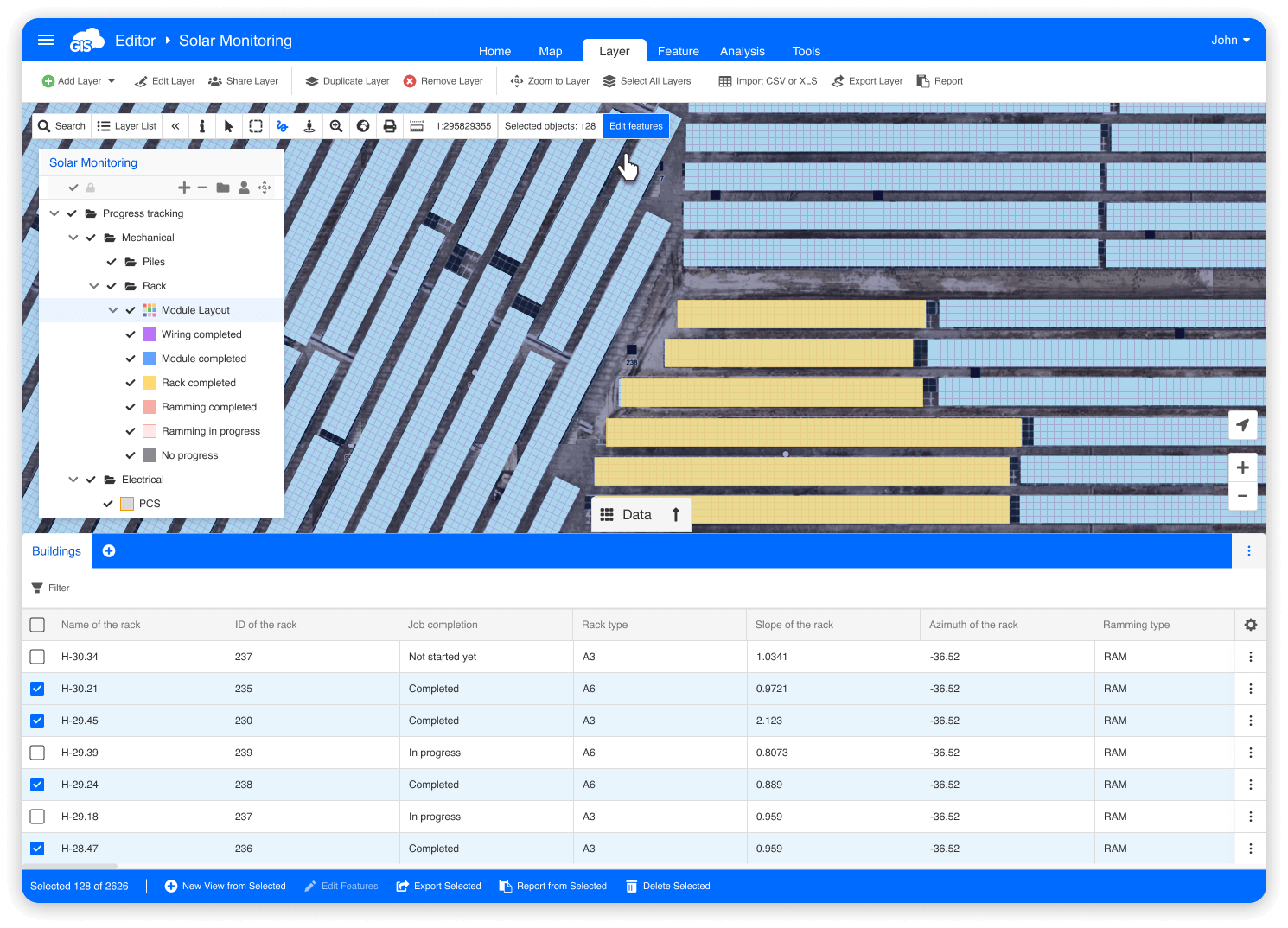
The inspector or site manager opens the solar farm map in GIS Cloud Map Editor. Using the lasso tool, they draw a selection around the section they’ve just inspected, selecting all features in that zone in a single gesture. The toolbar shows “Selected objects: 128.”
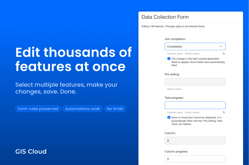
They click “Edit features.” A familiar form panel opens on the right side of the screen, showing the same form they use for single-feature editing. The info line reads: “Editing 128 features. Changes apply to all selected items.”
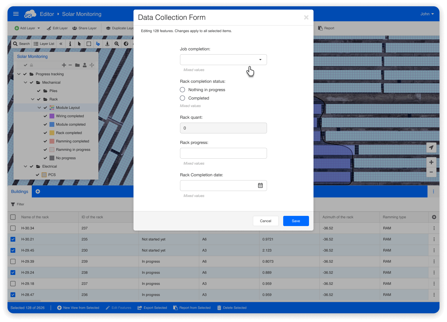
Fields with different values across the selected features are clearly marked as “Mixed values,” so the inspector immediately sees which fields have consistent data and which vary.
The inspector changes the status field from its current value to “Completed.” Instantly:
- The form automation fires. Completion date fields auto-fill with today’s date.
- Progress percentage fields calculate, and here’s the key: each feature gets its own calculation based on its own quantification data from another form field. Feature #1042 with 12 panels gets 100%. Feature #1043 with 8 panels gets 100%. The percentages match each rack’s actual specifications, not a blanket value.
- Dependent fields that are revealed by the “Completed” status appear in the form.
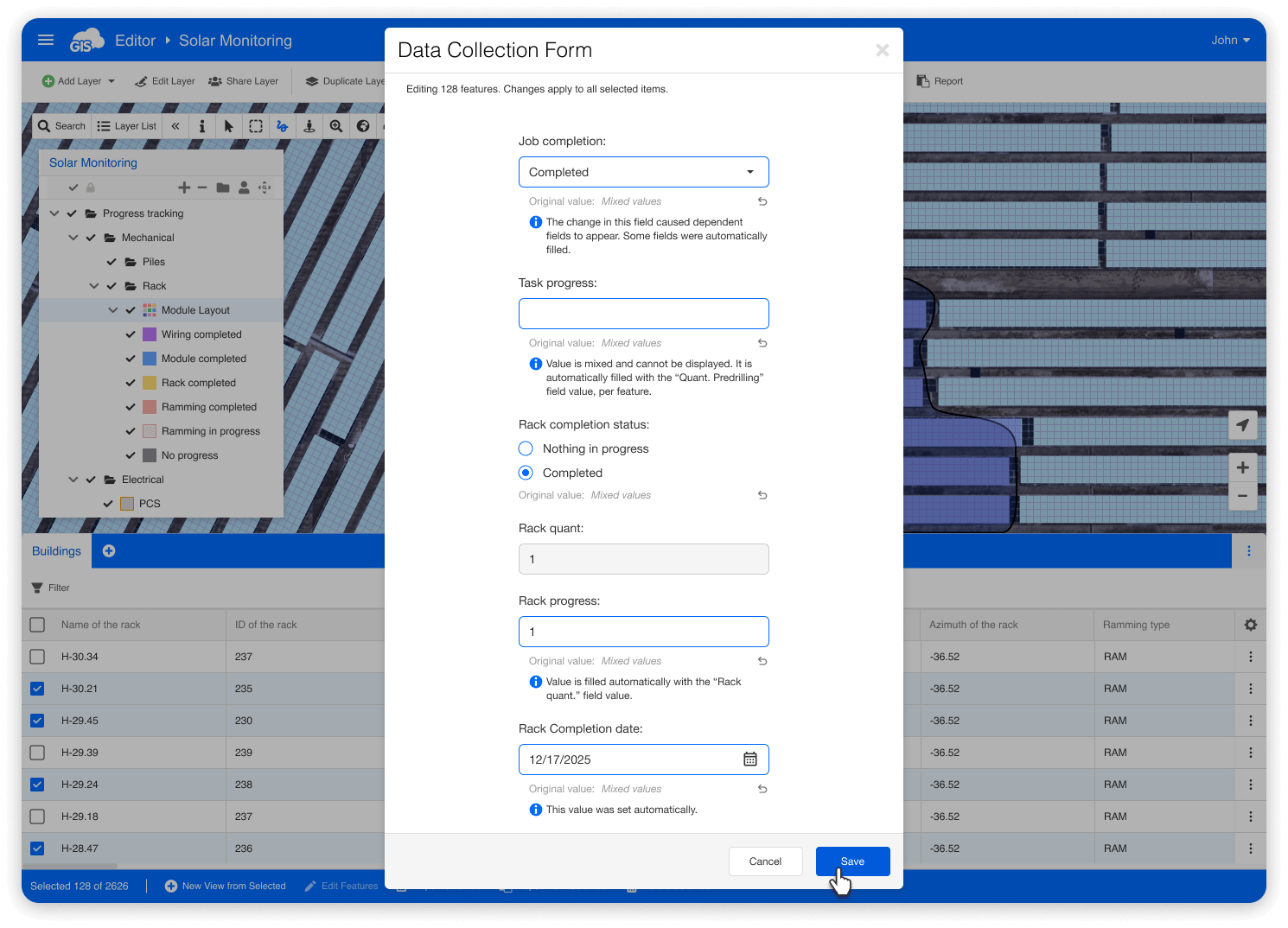
The inspector reviews the auto-filled values, makes any additional changes needed, and clicks Save.
A confirmation modal appears, listing every change: “Status: Mixed values → Completed. Completion date: No value → 2026-07-15. Progress: Mixed values → [calculated per feature].” The inspector reviews the summary and clicks Confirm.
128 features updated in under two minutes. All form rules respected. All automations fired per feature. All data immediately visible to the rest of the team.
From an Afternoon to Two Minutes
| Before Bulk Edit | After Bulk Edit | |
|---|---|---|
| Time to update 200 features | 2–4 hours (one at a time) or 30–60 min (QGIS round-trip) | Under 2 minutes |
| Form automations | Only in single-edit; lost in QGIS/CSV workflows | Fire during bulk edit, per feature |
| Per-feature calculations | Manual recalculation after QGIS import | Automatic, per feature |
| Data accuracy | Risk of manual errors, stale data during export/import | Real-time, validated, reviewed before save |
| Workflow disruption | Context switching between tools | Everything stays in GIS Cloud |
| Team visibility | Delayed — data not visible until re-imported | Instant — updates visible to everyone immediately |
Why Other Tools Couldn’t Do This
Three things about GIS Cloud’s Bulk Edit made it a fit for this workflow:
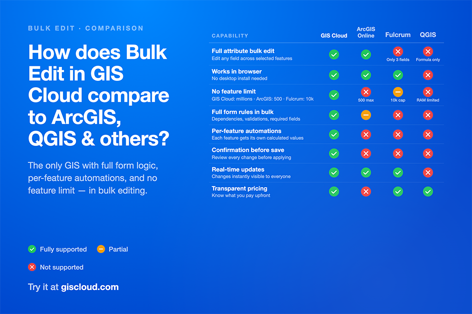
- Per-feature automation resolution. This is the capability that none of the other tools offer. ArcGIS Online added bulk editing in 2025, but it doesn’t resolve automations per feature during bulk operations. QGIS doesn’t have form automation at all. For solar farm inspections where every component has different specifications, per-feature calculation isn’t a nice-to-have — it’s a requirement.
- Full form logic, no exceptions. The team’s forms are complex — multi-level dependencies, conditional automations, required fields, read-only protections. All of this works during bulk editing exactly as it does in single-feature editing. There’s no “simplified bulk mode” that skips rules.
- Confirmation before save. When you’re updating hundreds of records, seeing exactly what’s changing — and what’s being auto-calculated — before committing is the difference between confidence and anxiety. The confirmation modal lists every field change with old and new values.
20 Panels or 10,000 – Same Workflow
Most daily bulk operations involve 20–100 features, a typical section update after completing a construction phase.
Larger operations happen during quality reviews, where a site manager may select 500–2,000 features to verify status consistency across an entire site zone. End-of-project audits occasionally involve selecting all features on a site, potentially 10,000+ to confirm everything is properly completed and documented.
GIS Cloud Bulk Edit handles all of these without degradation. There’s no enforced feature limit. The same form, the same rules, the same confirmation flow, whether you’ve selected 20 features or 20,000.
Coming Next: Bulk Editing on Mobile
The web version of Bulk Edit is live now. The next phase brings this capability to GIS Cloud’s Mobile Data Collection app, so field inspectors can make bulk updates directly from their tablets and phones on-site.
For solar farm inspections, this means the person who just completed the physical inspection can immediately select the relevant features on their mobile map and mark them as done, without returning to the office, without handing off to someone at a desk, without any delay between the work being completed and the data reflecting it.
The mobile version will support the same form logic, the same automations, and the same per-feature calculations. The primary selection method will be touch-based lasso on the map, matching how field workers already think about their sites (spatially, not by feature IDs).
Mobile Bulk Edit is currently in planning. Sign up for early access/notification when available.
Try it
Bulk Edit is available now in GIS Cloud Map Editor, enabled through a user option. It works on any layer, with or without a configured form.
For a step-by-step guide, see our Learning Center tutorial.
For a comparison of how GIS Cloud Bulk Edit stacks up against ArcGIS Online, Fulcrum, and QGIS, see our detailed comparison.
The leading renewable energy company operating across Asia-Pacific is a GIS Cloud customer. This case study describes how they use the Bulk Edit feature for solar farm inspection workflows. Details are based on requirements gathered during the product design process and reflect real-world usage patterns.