The project is a part of a larger initiative that tries to tackle the spread of disease caused by extreme air, water, and soil pollution in Bangladesh. The initiative plans to establish a disease surveillance system and conduct a spatial analysis to determine high-risk areas. This is a pilot project and covers the first step of a broader initiative, the mapping of communities and settlements in Bangladesh as the current data is of low quality if there is any at all (settlement names, their size, population, etc.).
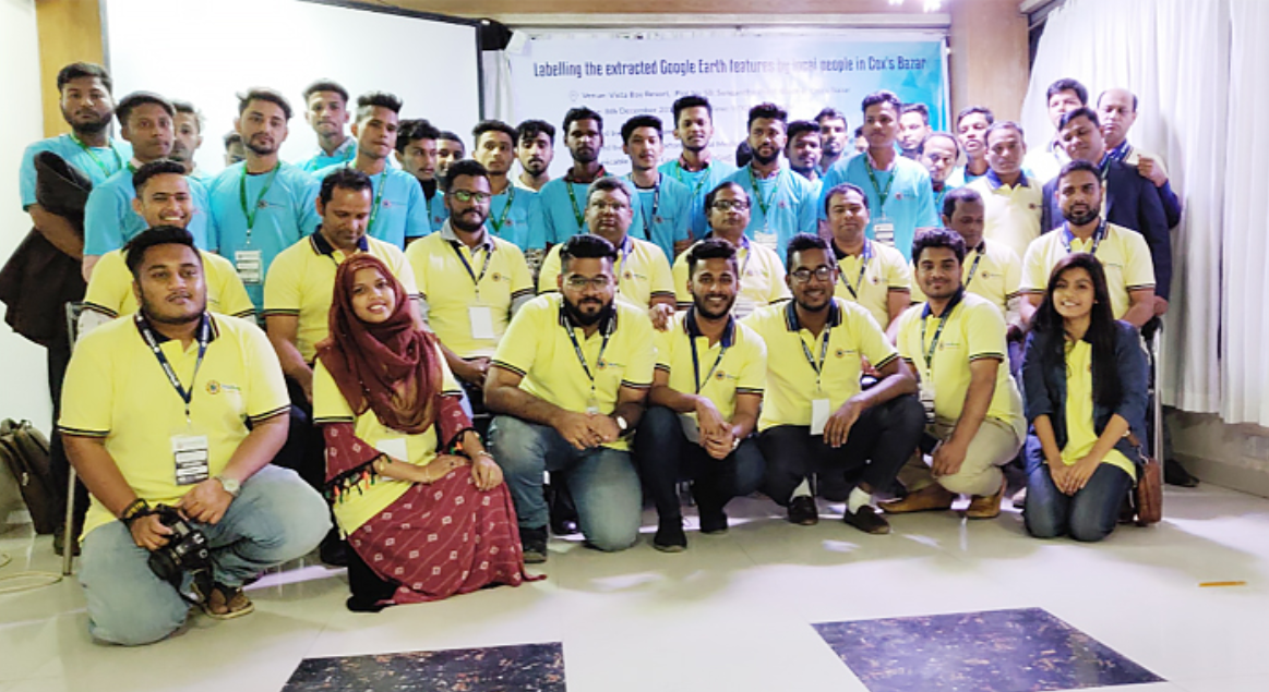
To lift the project from the ground, a team of researchers and scientists formed the GroupMappers non-profit. The organization was here to round up volunteers that would contribute to collecting and integrating geospatial data for the disease surveillance system.
The project won the 2nd place at the GIS Cloud Contest in 2017 and was provided with a suite of GIS Cloud applications and support from the GIS Cloud team.
Table of contents:
- The Non-profit Behind the Project
- About the Project
- The Challenges
- Data Collection Workflow
- The GIS Cloud Solution
- Results and Future Plans
The non-profit behind the project
GroupMappers is a nonprofit organization composed of mappers in Bangladesh who voluntarily contribute by collecting and integrating geospatial data for the disease surveillance system. It is organized by Mahidol-Oxford Tropical Medicine Research Unit (MORU) Epidemiology Department and funded by a Public Engagement Bursary from the Wellcome Trust. The founders of this organization are Prof. Richard J Maude who is the Head of Epidemiology at MORU, Dr. Ipsita Sinha, research physician and Sazid Ibna Zaman, GIS Specialist at MORU Epidemiology department.
About the Project
The pilot project goal was to develop a low-cost method for collecting and integrating geospatial data. Also, it was important to make the data available online to maximize the potential benefits of data for a wide range of possible uses.
The first part of the project was extracting communities/settlements from Google Earth, either as a point or polygon features. The second part was labeling and naming the extracted communities/settlements with the help of volunteers and local people. The volunteers visited the settlements to find the locals that could validate the settlement name and then collected all the necessary data with the Mobile Data Collection application.
The Challenges
In Bangladesh there is a lack of accurate, up-to-date data about community names and settlement sizes in rural or inaccessible areas. The lack of data makes it hard to plan healthcare delivery or set up a disease surveillance system. Gathering the data entailed a lot of field work so GroupMappers wanted to implement an effective field data collection method. They mentioned that collecting this type of data with conventional methods is too expensive and time-consuming (paper-based maps and forms, expensive GPS handhelds).
Another challenge was the lack of a common geospatial platform that would enable the stakeholders to share location data. Different organizations collecting field data with different tools would make it hard to integrate in one place.
The worries didn’t stop here. Initially, GroupMappers considered to validate local names with paper maps and then using volunteers to crosscheck the place names. But there were many difficulties. For example:
- Printing high-resolution images with other associated information on several paper maps was time-consuming, expensive and not easy to set up.
- Finding places with identifiable landmarks with paper maps was not easy.
- Training local people who were not very familiar with the paper method proved challenging to carry out.
The GroupMappers team dealt with all of these problems by creating an effective data collection workflow.
The Data Collection Workflow
GroupMappers work collectively by engaging groups of volunteers for field data collection and crowdsourcing tasks. Under the current pilot project, the methods used are being developed and optimized by the core team before a broader application.
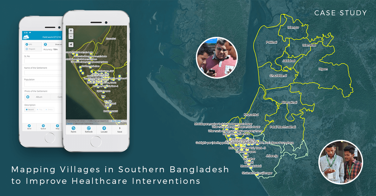
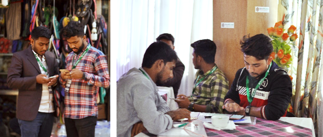
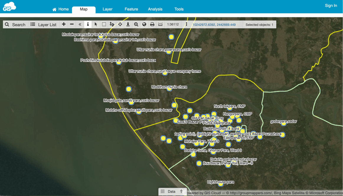
GroupMappers volunteers used satellite images from Google Earth to mark the communities and settlements. Later on, they identified the marked points with the help of local people for every particular community (crowdsourcing). For validation purpose, they used the Mobile Data Collection app to gather settlement locations, village names, size, photo, etc.
A quick overview of the workflow:
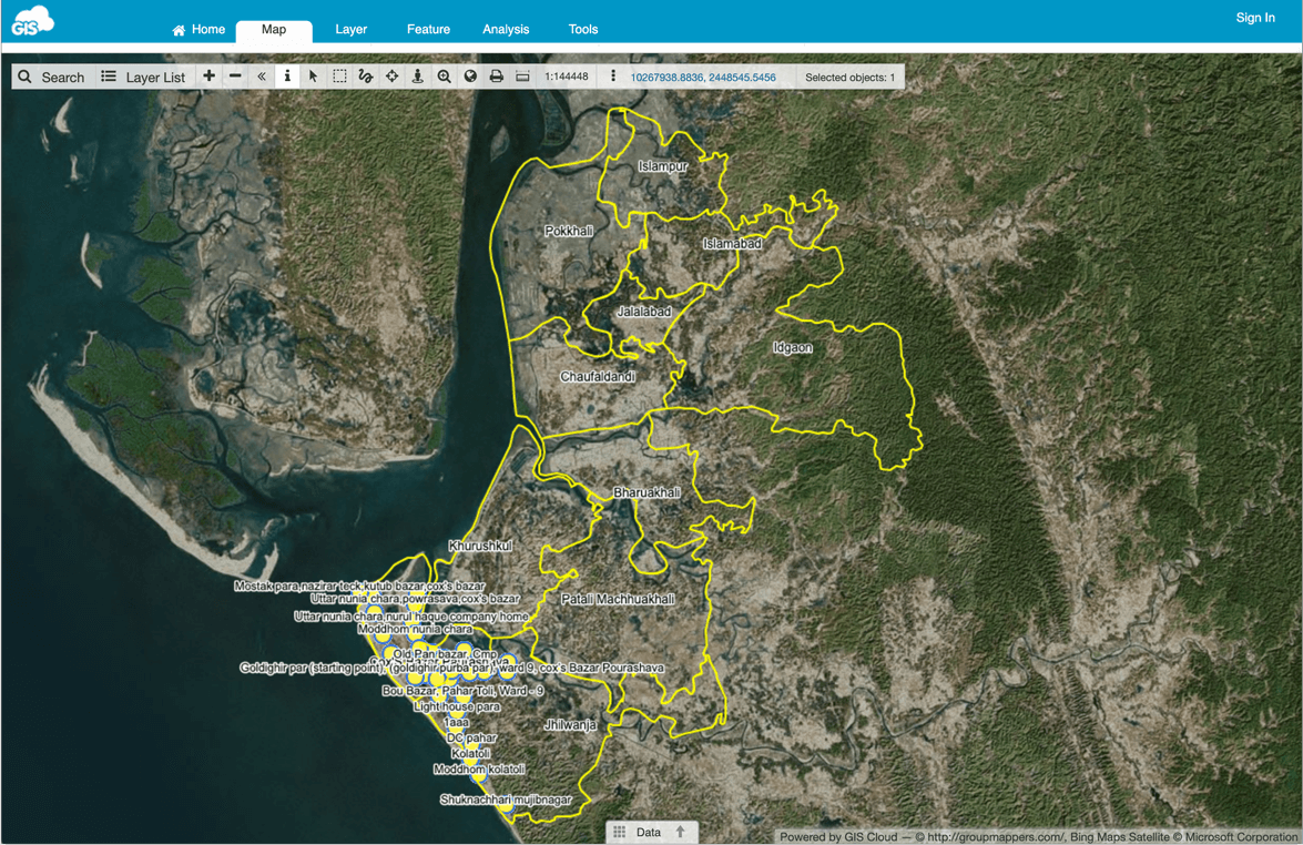
- 1. Collecting the locations of communities by marking them as polygons on satellite images using Google Earth. Volunteers allocate grid squares to mark communities using standardized methods and following a set of predefined rules.
- 2. The polygons are exported as a KML file and sent to a validation team who assess the quality and accuracy of the data against a set of quality criteria and approve or reject the dataset. Any rejected datasets are annotated and reassessed.
- 3. Volunteers are assigned to the study area to collect the names and other info about the marked communities. GroupMappers used Mobile Data Collection app for data collection while running the pilot project.
“The easy, understandable app interface, offline use and extraction capabilities of multifaceted data are the main capabilities which helped in many ways and helped to reach goals in a shorter time frame.” – GroupMappers Team
GIS Cloud apps supported the third part of the workflow, so let’s dive in and explore the data collection solution.
The GIS Cloud Solution
The Mobile Data Collection app was used to validate the pre-extracted data in the pilot project. The previously selected areas were divided into specific grids where groups of volunteers were assigned. With the help of MDC app, volunteers went to the already decided locations, took pictures of prominent landmarks, collected local names of the area, population data, and GPS value.
“App interface was easy to use and a very effective way of labeling communities. It made the project a lot more efficient as it was paperless work. It is the latest technology based, so the accuracy is ensured. It is also a faster and easier way of collecting field data and performing fieldwork and surveys.” – GroupMappers Team
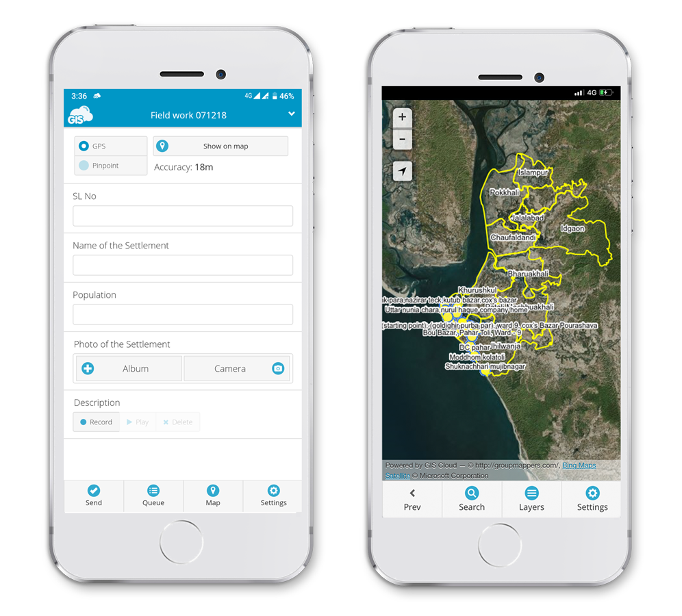
The MDC app enabled the volunteers to take pictures, GPS point locations, any text and numeric data, and all of that in areas with no internet connection. These features helped GroupMappers to collect the field data in the most effective way.
Top 3 benefits of the Mobile Data Collection:
-
- 1. Using mobile apps instead of paper maps.
- 2. Reduce the cost of field data collection.
- 3. High-quality pictures.
- 4. It works in offline mode.
“GIS Cloud provided a wonderful platform for data collection that can be operated through with mobile devices. The interface of the app is very easy to use. Even the installation of the app and data collection using the app is quite easy for beginners as well.” – GroupMappers Team
To edit the collected field data the GroupMappers used the Map Editor web app, as well as the Map Viewer app for sharing the data with other stakeholders and volunteer groups. The apps allowed all of the involved teams to have real-time access to the data.
Results and future plans
The pilot project was a success, but it will take a lot more time to finish the whole project. So far, GroupMappers have completed 75 percent of work and finalized the data extraction from Google Earth. There’s still a lot of work needed to improve further the methodology for naming communities/villages.
The healthcare sector will use the data to estimate the impact of several diseases and their intensity. The ‘hotspot villages’ can be easily identified by combining disease data and the data gathered in this project. The data enables healthcare professionals to send interventions to the right villages.
GroupMappers will also make the data freely available online because the data can have a wide range of uses in different policy-making sectors.
“Our plans for the future are to create a strong database with up-to-date information, and we’ll try to find a way to keep the information relevant. We will share this information at no cost. The fruition of the whole project will serve Bangladesh greatly and other sustainable development projects across the country.” – GroupMappers Team
Interested in trying the Mobile Data Collection app? Try out the 30-day free trial or contact our sales consultants and schedule a live demo.