Utilizing Drone Imagery – From Spatial Data to Spatial Knowledge

Contemporary mapping landscape is changing rapidly. Over the last few decades, most of the surveyors worked with total stations and GPS receivers for point to point data collection on a day-to-day basis. A usual workflow would end with using collected data for generating 2D plans of the mapped area.
Recently, we are witnessing a shift in surveying and mapping technology due to rapid hardware and software development. One of the most striking cases is that of Unmanned Aerial Vehicles (UAVs) or drones.
An Expanding Market for Drone Mapping
Federal Aviation Administration in the US predicts that by 2020, the number of drones flying above American soil will increase up to 30 000 vehicles, resulting in a 90 billion dollar industry.
The global commercial drone market is already benefiting from applications in many different industries such as agriculture, energy, construction, emergency response and a lot of others. Both surveyors and these industries need accurate spatial data on a day-to-day basis.
Today, mobile mapping systems such as UAVs provide an easy and cost-efficient way for collecting a large amount of high-resolution spatial data. With the help of drones, it is possible to complete previously time-consuming tasks within a day – including preparation, flight, image processing time and generating precise and up-to-date overviews for further project planning and management.
With quick deployment times and low maintenance costs, we can map pretty much anywhere, at any time. Drones allow us to use all kinds of payloads such as near infrared cameras to map vegetation chlorophyll levels for agriculture. Not only do drones make things cheaper and faster for a surveyor, but they also make our job safer. We can now survey areas remotely that perhaps have some environmental risks to them such as quarries, cliff edges, polluted areas, etc.
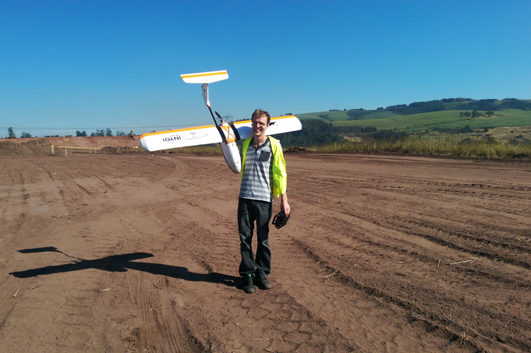
– Luke Wijnberg, 3DroneMapping

Luke Wijnberg from 3DroneMapping
So, when it comes to mapping with drones, many experts, and also non-expert users now have a chance to make their imagery created with drones. That is also an important reason for this rapid expansion in the drone market today. We should know that not all of this new drone users have experience with making sense of the data generated with drones.
Many of them may ask themselves what’s the real use of all that mapping and high-quality data?
From Spatial Data to Spatial Knowledge
Geographers often claim that 80% of all the data around us have a spatial component. Although the real percentage of spatial input in our cognitive processes may be lower – around 60% – it is still something that makes us think more about what is the basis of our daily decision-making process. Using maps for data visualization is just another way to overcome the limitations of chart-based reports and often inadequate verbal descriptions.
A map does not just chart, it unlocks and formulates meaning; it forms bridges between here and there, between disparate ideas that we did not know were previously connected.
– Reif Larsen, The Selected Works of T.S. Spivet
With great spatial data such as orthomosaic maps, elevation models, contours, profiles and volumes derived from processing imagery that is now easy to collect with drones, it becomes possible to bring decision-making process on a whole new level in a range of industries. Some examples of using drone imagery for improving workflows and decision-making process are landfill maintenance and management, precision agriculture or overseeing construction sites and quarries, where spatial data is used for project planning, overseeing and reporting purposes.
These examples point us to the fact that the real challenges brought to us by technological advancement introducing big data to a wide variety of users lie in making sense of technology in a particular working environment. How should we use collected data, how to filter it, how to share it, to whom and for what purpose? Or simply, how to use spatial data to create spatial knowledge?
In the end, spatial knowledge is always created, translated, communicated and used by someone, and we should know how to make it more user-friendly for real people in concrete industries so that they could make the most of the contemporary technology. So, our goal should be to create a better environment for creating and communicating this knowledge to various stakeholders. Namely, the real challenge of creating spatial knowledge is in collaboration.
The Future of Spatial Decision-making are Cloud-Based Collaboration Tools
Creating a good collaboration environment isn’t necessarily an easy task when we talk about big data such as sensor imagery and large raster datasets generated by drones. Users who need more than Google Maps Satellite imagery, because they want up-to-date field updates or different kind of sensor data like near-infrared photos, know that a large amount of data in various formats is often difficult for distribution between many users. Printed maps and large datasets on DVDs are slowing the information flow to the point of meaninglessness. This data is often restricted only to the use of experienced GIS staff who know how to operate software necessary for working with mapping data.
It seems that this approach becomes more and more pointless and is soon to be surpassed by a cloud environment for sharing and collaboration in the context of spatial ‘big data’ on a global level. Cloud environment already improves workflows in businesses, governments and community projects on a micro and macro level, sharing and editing charts, documents and images between many users in real time. When we talk about spatial data, cloud environment makes it possible to access real-time location data that can be updated in a matter of seconds, between users on different parts of the world.
Drone Mapping Use Case
Quoting Luke Wijnberg from 3DroneMapping, a cloud based-solution improved a construction-site overseeing workflow of his surveying company in the aspect of sharing big data collected with drones:
Using a cloud solution allowed everyone to see the entire site as it evolved from a remote location and always have the most up to date data.
– Luke Wijnberg, 3DroneMapping
They used GIS Clouds Map Viewer application for sharing drone generated spatial data with their clients. However, data sharing is only a first stage of an improved decision making for businesses, based on spatial knowledge.

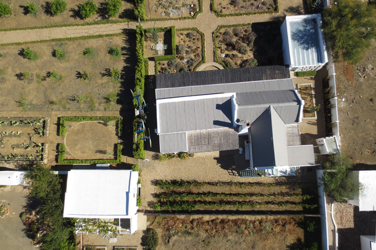
Aerial imagery generated by a drone, courtesy of 3Drone Mapping
Drone generated data, which includes processed sensor imagery can be useful as a snap preview of a certain area, but when it is shared without additional info attached (field reports, indexes and explanations), it usually doesn’t mean much for non-GIS users. That means that the added value of this data isn’t a preview itself, easily accessed through a cloud environment.
True collaboration starts when the drone generated imagery becomes a basemap for collaboration. Hence, when many different users from different departments, companies or agencies can simultaneously work on the same map, populated with different information (photos, reports, comments, recordings). Different stakeholders can have easy access to mapping data through GIS Clouds platform for sharing and collaboration, with a range of applications from Mobile Data Collection, through Map Editor and Map Portal.
GIS Cloud platform allows connecting and coordinating dozens of users located anywhere on a project, working in real-time on any device, at the same time saving time and money together with improving decision-making process.

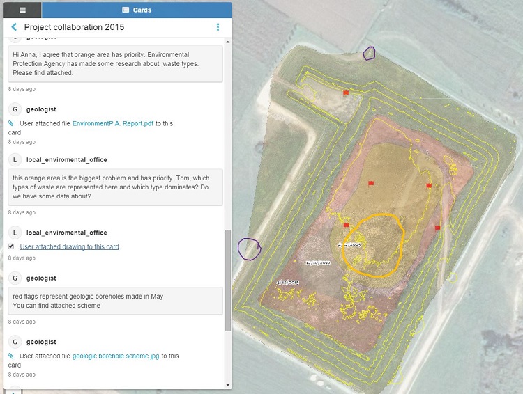
An example of a project collaboration in GIS Cloud
GIS Cloud allows using a map as a work board, where you can draw, add cards with comments, photos and pdfs while conducting a project. It can be used by a great number of users and accessed from anywhere, loading large raster datasets in a matter of seconds and at the same time not depending on desktop software or a computer performance. Most importantly, to collaborate using a spatial data component doesn’t require any special expertise or training – it is a user-friendly environment suitable for non-expert users.
And this is just the beginning. Want to try GIS Cloud solution for drone mapping? Sign up for a 30-day free trial or contact us.


