

The City of Maple Grove had a serious problem with an Emerald Ash Borer infestation. The first project the City undertook was to measure the condition of the public trees to identify the pest threat that has been severely affecting the trees in that area. Before the city could start the emerald ash borer treatment, they needed a proper tree inventory to map the infestation. The city issued a call for volunteers and got to round up a large number of senior citizens that were determined to stop the infestation. They decided to equip the volunteers with the Mobile Data Collection app because of the easy to use interface.
About Maple Grove
Maple Grove is a small community of approximately 60 000 citizens in Minnesota that’s highly engaged in promoting an outdoor lifestyle. Maple Grove is rated high by its residents as a great place for raising children, full of natural beauties and offering many great spots for maintaining a healthy lifestyle. To keep up with the image of a highly desirable residential area, the local government has to monitor and take care of over 1000 acres and 36 miles of meticulously maintained parks and trails and 48 playgrounds.
One of the first tree inventory projects the City undertook was to identify the tree species and various pest threats, like the Emerald Ash Borer, that have been severely affecting the trees in that area.
Challenges of the tree inventory project
The idea was to map out the trees and identify the ones infected with the Emerald Ash Borer. That information was crucial to the city tree maintenance department so it could react appropriately to the pest infection. The project needed a cost-effective solution for field data collection and visualization.
The field data solution needed to solve these problems:
- Replace complicated paperwork (processing, sharing, interacting and linking to multimedia) that demanded additional work in the office for data visualization
- Work in areas with no internet connection or restricted availability of GPS
- Easy to use for volunteers with no previous GIS experience
An Easy-to-use GIS Solution
The City of Maple Grove used GIS Cloud’s Mobile Data Collection for collecting data (location, photo and audio, along with data attributes on tree species) based on custom forms optimized for iOS and Android devices.
The data collection workflow was simple:
- 1. Analyze a tree to discover if the Emerald Ash Borer is present
- 2. Assess the damage caused by infestation
- 3. Filling out the mobile form with appropriate information (tree type, number of trunks, rate of decay, invasive species type…)
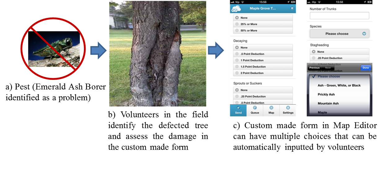
They used Map Editor for visualization, classification and analysis of collected tree and pest data. To manage the field data, they created maps that were also a great resource to volunteers that used them to navigate to the point of interest and have a real-time overview of tree date.
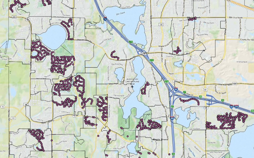
Map Viewer was used for internal data sharing between employees across all departments, who needed relevant and real-time information in order to react accordingly to the pest infestation.
Map Portal was an ideal solution for sharing the results of Maple Grove’s projects with the community in the form of a customized and simplified user interface which allows the public to get relevant information about the projects in their area, specifically about trees affected with pest threats.

Key benefits of the GIS Cloud solution
- iOS and Android smartphone devices were used for collecting data, which significantly reduced the project costs
- There was no need for excessive paperwork → all information about a tree (text, photo, audio) could be gathered with one device in a single form
- Offline mode allowed volunteers to collect data in areas without internet connection
- The pinpoint tool was also helpful, for volunteers to manually place the point on the map in case of low GPS accuracy in that area.
- All collected data in one place, available to any department within and outside of the organization, in the office or in the field.
- High-quality spatial data visualization, management and analysis for end users with different levels of GIS knowledge
- Option to access all gathered data privately on tablets and smartphones in the office or the field in case they need current information about the monitored asset
- Opportunity to have their projects open to the public in the form of a Map Portal which would allow the community to see the results and engage in the current projects in their area.