
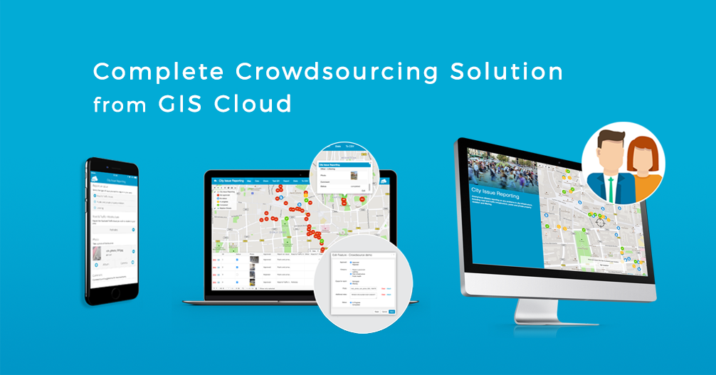
Every organization needs to gather and manage data, especially location-based data which can be represented visually on a map. Crowdsourcing apps are used to collect data from a large number of users using a single app on their mobile devices. Administrators control the information and decide whether it will be accepted and visible publicly, in a crowdsourced map portal.
When we talk about Smart Cities and online communities, we can say that collaboration and citizen engagement can drastically change city dynamics. With significant growth in mobile technology and availability of smartphones, crowdsourcing apps have taken over the marketplace with almost 60% of the annual increase in the Market Size (2016). Acquiring feedback and ideas from a large group of people and outsourcing tasks brings substantial advantages to your city or organization.
That is why we are excited to present our GIS Cloud Crowdsourcing solution for governments, organizations, and cities with a goal to engage communities in active citizenship.
Creating your branded crowdsourcing application
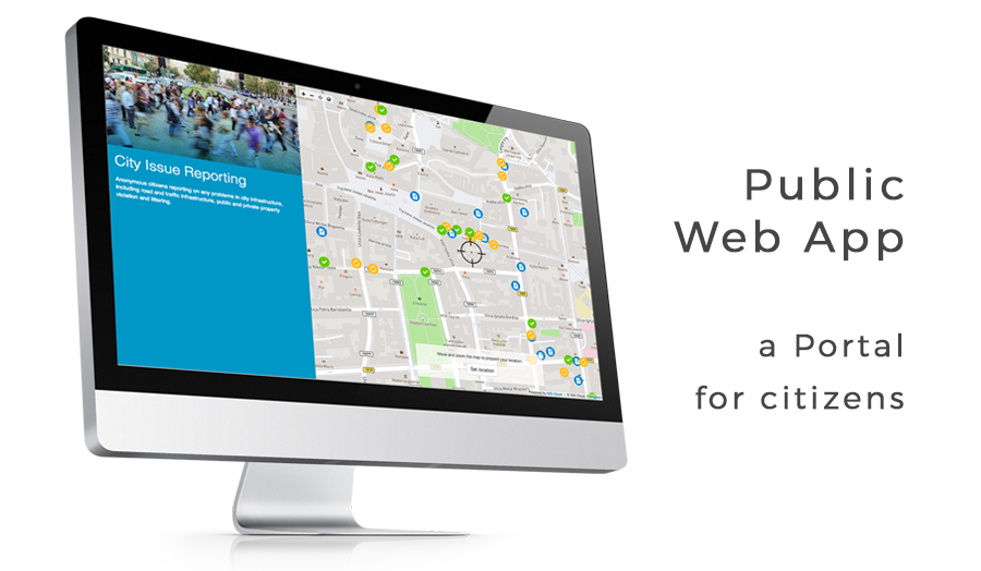
GIS Cloud Crowdsourcing apps are configurable applications, customized and branded for each client individually. Once the crowdsourcing mobile app is built and branded, citizens and organization members can download the Mobile App directly from App Store or Google Play. At the same time, Crowdsourcing Web App is instantly accessible, and it allows citizens to anonymously report issues online from their desktop computers. Project Coordinators can track the submissions and review the reports to decide whether they will accept them, using the Admin Web App. They also control the visibility of reported issues by approving them for public viewing.
An organization can create a unique survey project by creating a custom form using GIS Cloud form builder for Mobile Data Collection. This form, along with the colors and logo from an organization, is the basis for the crowdsourcing data collection app the GIS Cloud team builds in a matter of days. Survey and form fields can be easily modified at any moment using the same builder they were created in. Forms are quickly deployed and instantly updated on Mobile and Public Web Apps. Once you’re done setting up your project and the app is built, citizens can download the app and start contributing to your project immediately, without the need to create an account.
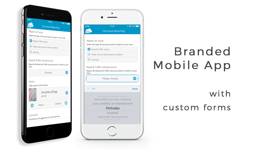
A project is presented to citizens as an interactive map, used to report a problem or observation. Citizens can easily and anonymously submit reports about a location or an asset, including photos and comments using Mobile or Web App. They can track status and review existing reports, vote on critical issues in their areas and publicly propose a solution. Everyone benefits from collaboration due to more effective communication, more efficient delivery of services and faster response time in the process of reporting and solving issues between organizations, cities and the public.
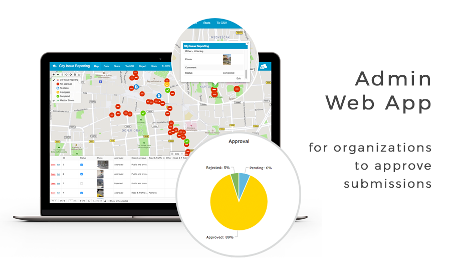
The main application used to edit crowdsourcing projects is the Admin Web App, which is only a part of the Crowdsourcing solution. Project form can be modified at any time, and it can have many different attribute field types (Date & Time, Checkboxes, Photos, Audio field, etc.). This app allows the Project Coordinator to review submitted reports, problems, and observations.
Project Coordinator can approve or reject submissions, update the status of the reported issue and coordinate between departments. He can also track progress and have an overview of statistics through graphs and charts.
The project Coordinator’s ability to approve or reject a submission for public viewing stands as a form of protection, that is data liability control because not all submissions are always complete or adequate for release to the public. Project Coordinator will accept only the reports and submissions that are complete and in compliance with the regulations of the organization which is collecting the data.
After the data is collected, you can use other GIS Cloud apps such as Map Editor to style and analyze the data, import more layers of data to have a better overview of the project, as well as to share it with other interested parties. You can also organize teams which have to do repairs or replacements or confirm the reported issues.
Crowdsourcing use case: City Issues Reporting and Neighborhood Development
With many problems cities are facing around the world, crowdsourcing tools have proved to be an ideal solution for organizations that wish to promote more efficient community governance. The City Issue Reporting and Neighborhood Development use case presented in this article aims to engage the community in active citizenship with a goal to transform and improve cities together with local and city leaders. Following the Smart City trends, engaging citizens to get more involved in identifying issues, neighborhood development and implementation of solutions in their areas will benefit the overall city structure, strengthen communication and interconnect technological infrastructure in a city.
Project area chosen for this use case is the City of Zagreb, the capital of Croatia. The project consists of two parts, City Issues Reporting and Neighborhood Development.
The first part aims to engage citizens engage in crowdsourced mapping to report public and private safety issues, road and traffic or littering issues in the city. Citizens who wish to collaborate can report neighborhood issues like graffiti, illegal occupancies, broken windows, maintenance of non-residential structures, sidewalk obstructions, potholes, low visibility intersections, illegal dumping sites and many more general and specific issues in the city. Registering and forwarding citizens concerns about neighborhood issues to the City Services results in a more efficient and effective city management system.
The second part of the project was focused on citizens reports, suggestions and comments on neighborhood development opportunities and potential improvements in park & recreation, road & traffic and utility infrastructure. Citizens who wish to include in the development of their neighborhood can suggest neighborhood improvements like an extra bench, street light, a new playground for kids, trash cans, recycle bins, video surveillance, pedestrian crossing or noise barrier and much more. Project Coordinator evaluates and prioritizes the reports, suggestions and comments then forwards those to the City District Committees that are responsible for implementation of future improvements.
Challenges when collecting data from a large number of users
It is often hard to gather data from a large number of citizens or members of a big organization, and have all data centralized in one place. Let alone to be able to organize the data, track the process of ongoing projects an report to the public and stakeholders on the project status. Existing solutions for data collection rarely offer the possibility of including thousands of collectors in the process, using the same simple application for the same project or a goal.
The key challenges for organizations are to find an efficient way to:
- Visualize and categorize reports on a map
- Review and approve submissions for public viewing
- Prioritize tasks and reduce response time
- Coordinate teams and plan actions
- Monitor progress and track details of an individual report in real time
We held two webinars regarding a specific use of our online crowdsourcing platform in different industries, which can help you to understand the workflow of an organization using this solution.
The first webinar was about Crowdsourcing for Utilities, explaining which problems can be solved by crowdsourcing spatial data from your clients and coworkers.
The second webinar showcased crowdsourcing solutions for NGOs and Nonprofits who wish to attract sponsors, support micro-volunteering practices and engage communities in various projects.
A complete solution to engage citizens
GIS Cloud Crowdsourcing app is a perfect solution for engaging citizens in the city development. Project Coordinator creates a unique form using GIS Cloud form builder, which is then built into a unique branded app, accessible as a Mobile or Web App to citizens and the public. Citizens report issues using automatic geolocation or by pinpointing the location for better precision.
Reports include photos, comments, descriptions, suggestions and additional information relevant to a project. Project Coordinator evaluates received reports, problems, suggestions, and observations, and approves or rejects submissions for public viewing.
Allowing the public to view reported issues, comment and propose solutions to problems, makes citizens feel more involved in the decision-making process of the city they live in. Both project Coordinator and city leaders can track the progress and status of reported issues using charts and graphs in the web interface. Project Coordinator can forward issue reports or development suggestions to a city department responsible for it’s solving. Establishing critical infrastructure and delivery of services effectively and efficiently completes the circle and thus increases connectivity in a city.
Crowdsourcing solutions are strategic models used to open up governments and cities to fresh and innovative ideas and solutions. Crowdsourcing data collection can be applied in a variety of different industries and projects like environmental protection, rising crime rates, unemployment, overcrowding and urban sprawls, resource management and many more. It is a powerful tool that can change organization dynamics and become the primary tool for decision-makers in organizations and communities.
Take a look at this amazing project which aims to preserve national heritage of drystone in Croatia, using Crowdsourcing solution alongside other GIS Cloud solutions.
If you want to learn more about GIS Cloud Crowdsourcing Solution or try it for yourself, contact our consultants and they will get you started.