
Orange County, California (OC) with the population of over 3 million people, is the third most populous county in California, behind only Los Angeles and San Diego counties. The County is famous for its attractions such as Disneyland and Knott’s Berry Farm, its beautiful beaches along more than 40 miles (64 km) of coastline, and as one of the most desirable locations to live in the United States.
Orange County’s economy is a standout in Southern California and is expected to accelerate through 2015, as the region’s better-than-expected job growth drives the county’s housing recovery.
– Los Angeles Times
With increasing development and a population that has more than quadrupled in the past 50 years, there has been a growing need and challenge for managing the resulting growth in land data information, as well as requests and dissemination of that information.
Various departments in Orange County had a variety of systems and applications for managing their location and parcel data, and in 2009, 15 different departments put together a working group and commissioned a study of the County’s GIS use and future needs, which were characterized as follows:
County of Orange departments rely on information to carry out their various missions for public safety, land planning, social services, infrastructure management, taxation, and stewardship of natural and man-made resources. Nearly 90% of the information is location-based, meaning that each information item pertains to a place on the earth. This fact has given rise to the extensive adoption of Geographic Information Systems (GIS) to improve the efficiency and effectiveness of governmental and private sector operations.
The study had identified a broad need to share and collaborate on an enterprise-wide basis, and the needs extended beyond the enterprise to the entire ecosystem that needed location-based information created, stored and maintained by the County.
As this study was being finalized, cloud computing was becoming a reality, and maturing toward mainstream adoption at an unprecedented pace. The cross-department committee at Orange County was convinced that a cloud-based GIS deployment was going to be the key for achieving the broad adoption and dissemination of GIS workflows among the many constituents of the County government and ecosystem.
After considering a number of options and vendors, several groups within the Orange County Public Works department decided to move ahead with solutions based on GIS Cloud.The cloud-only platform was chosen as a solution for OC’s data management through its mission of being “a more accessible way of visualizing, analyzing and sharing geospatial data.”
By using GIS Cloud applications like Map Editor, Map Viewer, Mobile Data Collection and Map Portal, a number of solutions and projects were deployed within weeks of this choice. As GIS Cloud supports vector and raster formats, media integration and allows import of various data types, a cloud-based geo information repository could be deployed for a wide variety of projects, needs and data access.
GIS Cloud will present each of these projects and deployments as they are deployed, and three of the earliest and most prominent projects that incorporated GIS Cloud technology:
- OC Data Portal
- Collaborating on Watershed District Adjustments
- Treasurer Tax Collector (TTC) Property Map
These initial deployments will give you an overview of how GIS Cloud apps can be used from the perspective of different organizations and constituents.
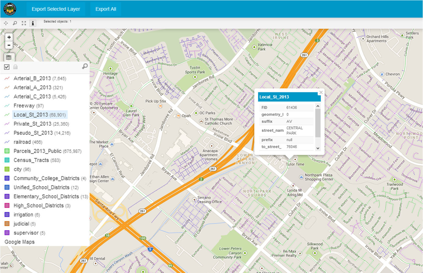
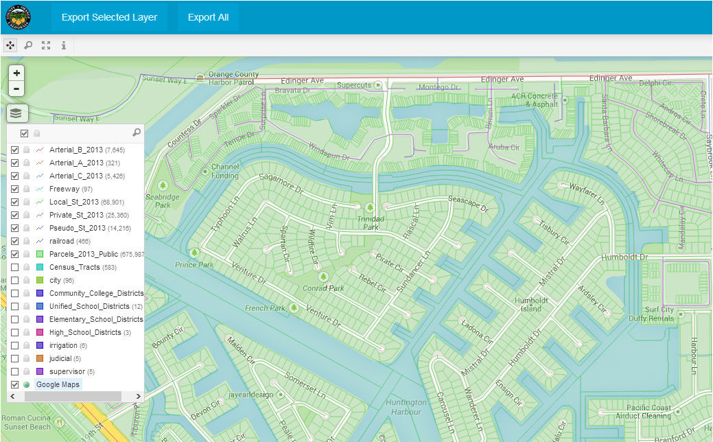
OC Data Portal
We will start with the OC Data Portal, which is available to the public at https://ocdata.giscloud.com/
Challenges
- Need to publish the Orange County land base and parcel maps to make them easily accessible to the public for viewing and downloading
- Customization of the layout view to present various layers of information maintained by the County
- Avoid having to ‘hand process’ requests for base maps
The County was required to make its land base maps freely accessible to the public as the result of a recent court ruling in the State of California. This meant that the County would either need to provide additional staff, or dump the data into .zip files on their web site. The County was just starting its pilot use of GIS Cloud, and they quickly realized a semi-custom data portal would provide a far more compelling, straightforward and cost effective solution.
Solution
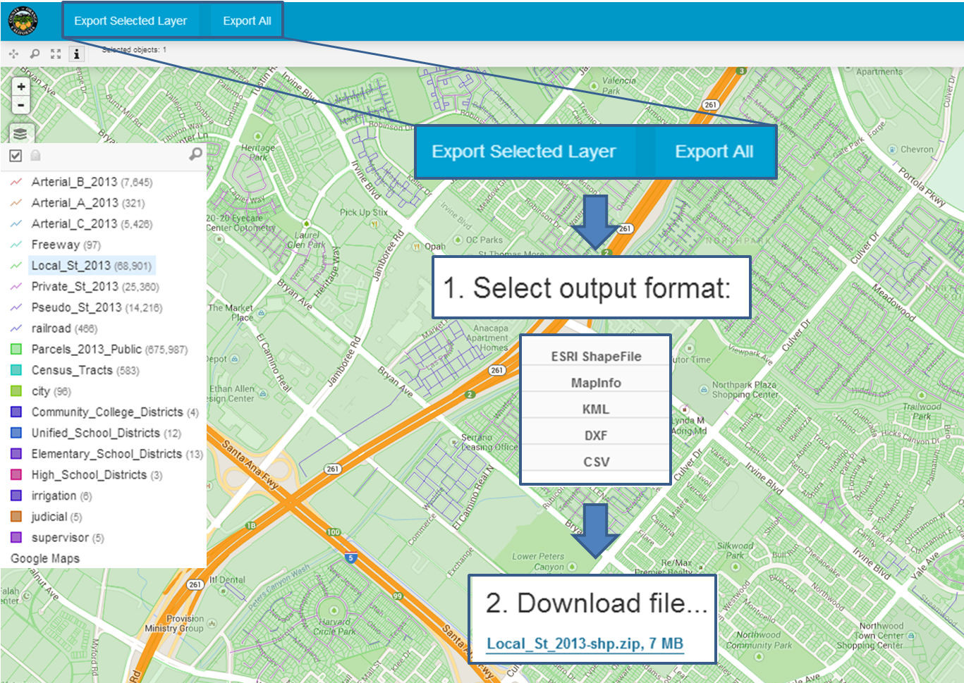
- GIS Cloud Map Portal provides customization options for the layout of the portal itself and uses the fastest vector based engine in the world
- End users simply sign up for free in Map Portal, which gives an insight to the authorities in terms of the data download
- Data Export in various formats (.xls, .shp, .dxf, .csv, .kml, etc.)
Results
GIS Cloud Map Portal was an ideal solution as it provides customization options for the layout of the portal itself and it uses the fastest vector based engine in the world. End users would simply sign up for free in Map Portal, which gives an insight to authorities in terms of who is downloading the data. Map Portal Export supports various data formats (.xls, .shp, .dxf, .csv, .kml, etc.) which made it easy to the County personnel to publish their land base and parcel data to the portal for the download by the public. This proved to be an affordable and user-friendly solution for OC by reducing time, effort, paperwork and support costs.