
How to research, collaborate, educate and optimize institutional workflows with the help of mapping technology?

Interdisciplinarity is a common word in the world of contemporary education. At the institutional level, it highlights one of the most important facets of increased flow of information and ideas – collaboration.
Literally, interdisciplinarity signifies working between diverse academic disciplines, while the main goal is to combine subjects together in new ways to achieve a specific purpose. That kind of prospect asks for intensification of networking and features collaboration between people with different academic and practical background.
Most of all, a need for an interdisciplinary approach is visibly present in sciences such as geography, definition of which strongly implies the notion of interdisciplinarity. GIS, Geographic Information System merges cartography, statistical analysis, and database technology, with the purpose of storing, analyzing, and displaying geographical information. This data can be used later on for the purposes of projects, decision-making, lectures and for other purposes. Using GIS software for academic needs magnificently serves the notion of interdisciplinarity in academic terms. The spatial dimension of research is important for disciplines in the range from environmental research, to archaeology or population genetics. All of these fields of study often require a help from mapping technology to display, interpret and analyze the data.
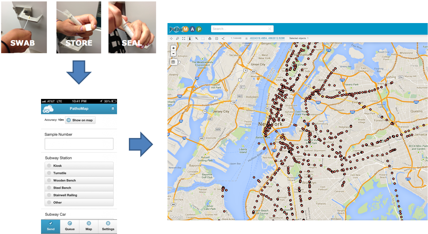
An example from Patho Map project : Displaying the pathogen map or “PathoMap” of New York City and surrounding areas
So, the first, most obvious use of GIS for academic projects in a wider sense is for the uses of collaboration on various projects between different disciplines.
In a more direct and narrower sense, GIS is widely used in educating the generations of geographers and GIS experts. But, we shouldn’t stop at educating only in the area of geographical research and theory. GIS software can also be used in teaching various subjects such as environmental studies, earth science, history, mathematics, chemistry, biology, languages, arts, etc. We can say that GIS technology is present on all levels of education, from elementary schools to higher education, where most of its academic usage is concentrated, unifying its purpose as a research tool together with instructive quality. For example, it is a very commonly used tool for undergraduate and graduate research projects. Observing widely, we can see GIS software used in schools, at technical colleges, universities, libraries, museums, and other educational institutions.
So, what would be the basic reason for such a wide application of mapping software?
As an instructional tool, GIS serves its purpose as a great way of encouraging students to employ critical thinking, engage in projects and surveys, and boost their problem-solving skills. This technology gives the students a good perspective in the visualization of spatial patterns, linkages, and relationships. It enhances their numerical and information processing skills and also helps develop the general linguistic intelligence needed for reading and interpreting visible symbols and word information. Taking into account a strong orientation on visual images present in the contemporary culture, there is no reason why educators wouldn’t encourage the rise of spatial and map literacy.
Namely, the importance of visual preview in education is supported by the fact that humans process images 60, 000 times faster than text. Also, people remember only around 20% of what they read alone, compared to 80% of what they see.
A history class is a good example in this case. Maps are used to communicate not only spatial, but also historical data. Therefore, interactive maps can be great teaching tools for history classes. They proved to be a good way for remembering a big amount of historical data.
Except for the great value of GIS software for instructional purposes, there is one more aspect of its usage in the education.
Mapping applications, as an essential part of GIS software, can also be used in educational administration and forming education policies.

Photo: Marta Klarić Ravnić
Some of the examples of GIS software application in infrastructure management and administration are:
- university infrastructure overview and planning
- campus planning and safety
- curriculum planning encompassing room capacities
- technology infrastructure
- emergency preparedness
- managing alumni network
- recruiting students
One of the ideas of how mapping software can be used is, for example, in university self-assessment, using the data for displaying the information such as teacher-student ratios, basic demographic data and various statistical parameters, including the state of infrastructure.
Last but not least: if we shift the focus from the academy to a wider system of educational policies, we should know that the geographic tools are very useful for policymakers, influencing various strategic decisions.
GIS helps visualizing important data about educational facilities and general statistics on local and national levels. It can display expenditures, performance, and compliance with educational regulations. It can show the data in a range from the literacy level of the students to the distribution of federal funds. Therefore, GIS is very important as an overview which informs the decisions connected with resources, program implementation, and distribution. Some types of data that can be visualized for educational policy strategies:
- amount of money spent per pupil
- teacher-student ratios
- geographical distribution of literacy levels
- demographical information in relation to educational data
- student, school, and district performance
- distribution of funds
- comparisons between states, districts, and school
All of these GIS possibilities, attached to an academic context often are limited with the restricted allocation of resources, primarily funds and technological infrastructure. For that reason, educators and academic staff are often inclined to use cost-effective and non-demanding solutions. One of the ways out of the situation of restricted funds and infrastructure is turning to Cloud GIS solutions.
In Part 2, you can read about reasons to use GIS in Cloud environment for educational and academic purposes.