
The electricity distribution system is one of the main parts of electric power systems. It’s important to transform existing systems and utilize the latest technologies to overcome issues such as power theft or poor distribution of power supply. Learn how the new line collecting feature in GIS Cloud can be of help in electricity distribution network management.
The continuous growth of population followed by advancements and improvements in complex electric power systems has raised big challenges for distribution network operators and electric utility engineers to supply, assure and enhance power system sustainability and efficiency. The GIS Cloud mapping technologies play a central role in planning, management and monitoring operations within the electric utility information system were powerful visualization and analytics tools can resolve data accessibility issues and improve the decision making process.
Critical role of GIS in the electrical Distribution system
Electric utility companies need to have two types of geographical information: a distribution network containing crucial technical information and locations of numerous poles, power lines, circuits, transformators, facilities etc., and consumer and billing information with a list of existing customers, their locations and consumption details to determine the areas for a potential customer and network expansion.
Utilities need accurate information on their asset inventory. Biggest problem electric utilities are facing is storing the historical data and updating it due to the real-time changes on the field. GIS Cloud technologies help utilities to manage relevant information about customers and distribution network with a perfect overview of the entire system visualized on a map. It can help utility engineers to identify patterns of distribution, demand and consumption to assess energy requirements needed to develop a profitable distribution system.
Many developing countries that still use traditional methods for asset management are looking to implement GIS in their system and simplify the process of mapping, managing and monitoring the overall state of the entire distribution system. With Mobile Data Collection application field surveyors can collect new information about the distribution network and map exact locations of their assets.
Mapping of electricity Distribution Network
Implementation of GIS systems in field data collection projects starts with creating a geodatabase containing relevant information about assets in existing electrical distribution system. In many cases, existing data is stored in paper-based forms which don’t have much value when it comes to efficient management of operations.
The main advantage of the GIS Cloud platform is the ability to map and link spatial and non-spatial data of the system to the point, line or polygon drawings on a map. Field operations managers create an online surveying form with different attribute fields such as voltage capacity of distribution line, installation date of a transformer, conditions and types of poles or geotagged photos and audio notes.
If you have existing historical data, you can import them to GIS Cloud database in Map Editor to create an official data repository of the distribution network. In many cases, the data is stored together with coordinates. However, the locations about different parts of the distribution system can be collected just as an address and can be georeferenced and placed on a map with Geocoder app.
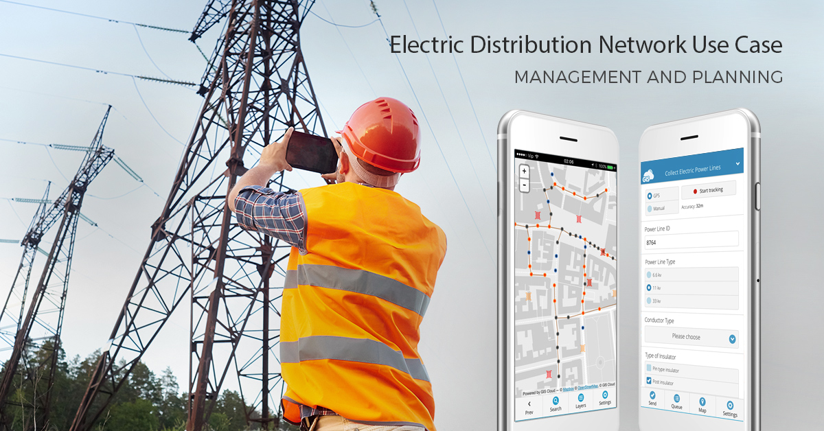
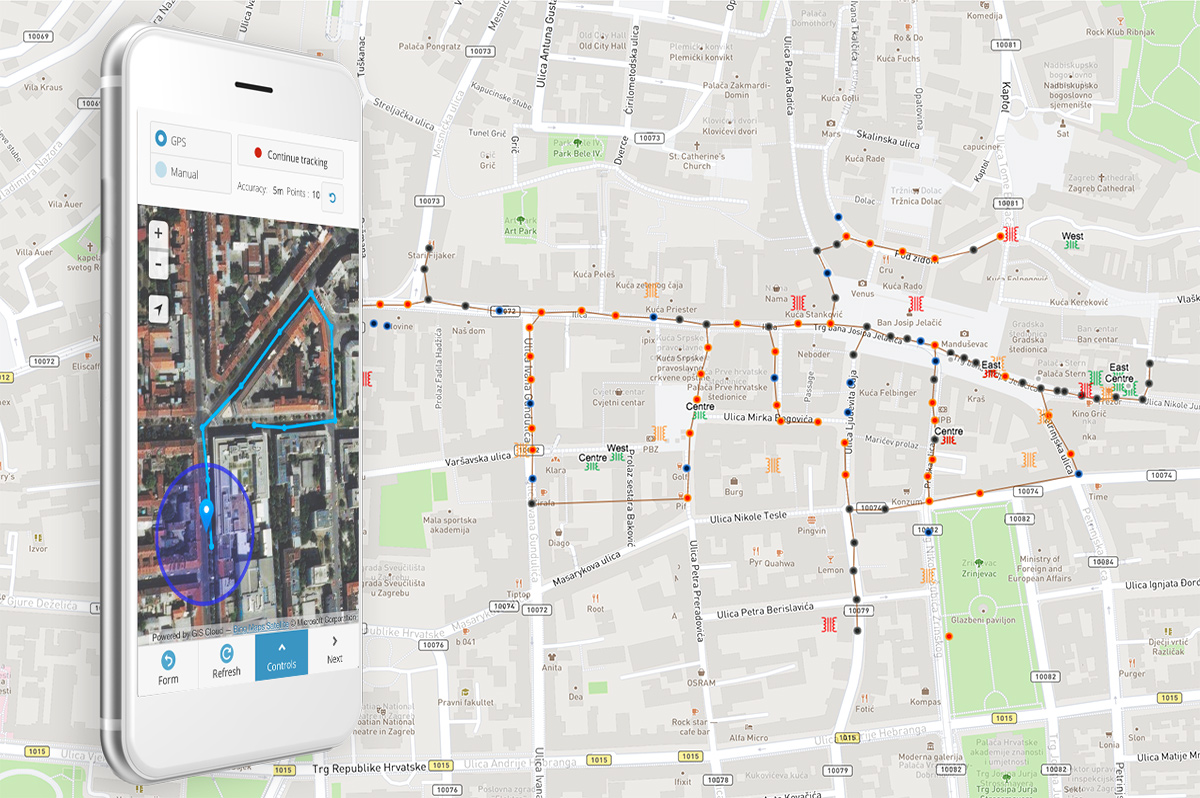
On the other side, you can start an entire asset data collection project from scratch and digitalize the electrical distribution system from electric poles, distribution transformers, power voltage lines and other assets in the electricity distribution network with Mobile Data Collection app. The locations and details of cable routes can be collected in the form of line drawings on a map.
With our newly developed feature in our MDC app, you can combine GPS tracking and manual line drawing methods to achieve maximum time efficiency and accuracy when mapping and managing large areas covered with the electricity distribution network. Field operators can do surveying projects to update and correct the existing information of distribution network in the shortest way possible. They can edit the location and attribute information of cable routes, electric poles and transformers both in the field or back in the office. The updates are visible in real-time thus giving a perfect insight into the data collection process for better control of the data quality.
Planning and Expansion of electricity Distribution Network
Extensive and continuous GIS surveying of electrical network together with consumer and billing information is providing utility managers with an improved operational and decision-making tools. Before making any kind of decision, utility managers are using the GIS database to answer important spatial questions such as where are the most suitable areas to place a new transmission line or where are the areas with most power outages and various system overloads.
Continuous population growth and the expansion of cities demands for a growth of electric distribution systems. With GIS Cloud Map Editor, utility managers can create spatial queries based on the information stored in the database. By analyzing various parts of the distribution system, utility managers can identify areas with aged infrastructure, areas with overload in system components, areas with various system loading conditions and areas with frequent power outages due to the possible electricity theft.
The insights from spatial analysis can help planners and engineers to improve the power supply and asset management, in the context of planning the new transmission lines or cables, resolve outages and improve consumer services.
With Map Editor, you can analyse the electric distribution system and other essential parts of infrastructure such as buildings, roads and possible obstacles to highlight the areas suitable for construction and expansion of distribution system.
Using Mobile Data Collection app, field operators can draw line features in highlighted areas and store them together with photographs and other relevant information for planning utility construction sites. With powerful search tool inside the app, you can access your data by typing in the ID number or any other attribute value. Utility planners can share the results to different stakeholders and communicate feedback to other vendors.
Complete solution for utility workflow
One of the benefits of GIS Cloud technologies is that there is no need for extensive education of your workers. The solution is implemented in your workflow immediately and it’s suitable for non GIS users as well as professionals. The option to collect line features in the field with high GPS accuracy and storing them in the database can increase time and cost efficiency of the entire organization as it offers more convenient way to collect data. The greatest benefit is the real-time collaboration between top management and field operators where maps and layers can be shared with different levels of access.
Sign Up for Free and setup your first line collection project for electric utilities with Mobile Data Collection app.
Watch the GIS Cloud for Electric Utilities webinar recording where you can also see a live demo of the apps.